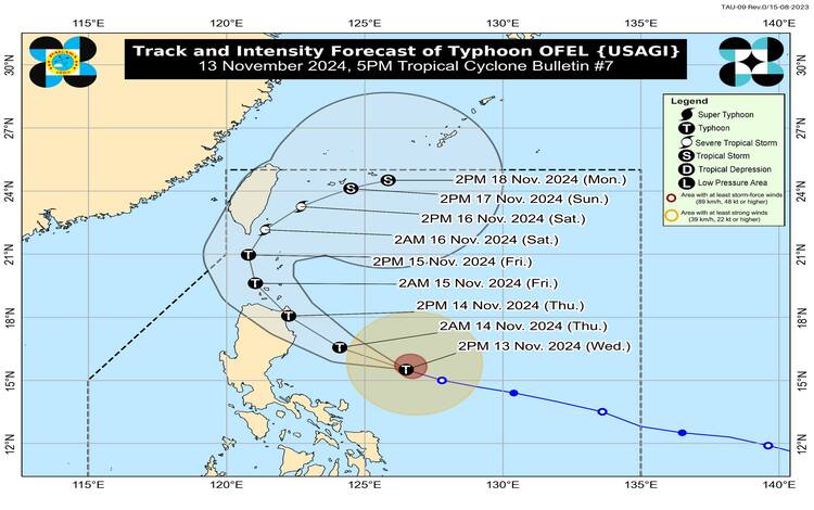
As of the 5 PM bulletin from the Philippine Atmospheric, Geophysical and Astronomical Services Administration (PAGASA), Typhoon Ofel (international name: Usagi) has intensified further and continues to pose a significant threat to Northern Luzon. The typhoon’s center was pinpointed at 480 km east of Baler, Aurora, based on data from the Daet Weather Surveillance Radar. Moving west-northwest at 25 km/h, Ofel has sustained winds of 120 km/h and gusts reaching up to 150 km/h, with a central pressure of 975 hPa.

Areas Under Tropical Cyclone Wind Signals
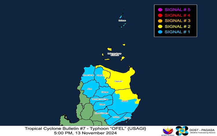
As Typhoon Ofel nears the Philippine landmass, several areas have been placed under tropical cyclone wind signals due to anticipated impacts:
- Tropical Cyclone Wind Signal No. 2 has been raised over:
- Luzon: Cagayan (including the Babuyan Islands), northern and eastern Isabela (including municipalities such as Maconacon, Divilacan, and Palanan), and eastern Apayao (areas such as Flora and Luna).
- Wind Threat: Gale-force winds with speeds of 62 to 88 km/h are expected within 24 hours, posing a moderate threat to life and property. Residents in these areas should prepare for potential structural damage, flying debris, and disrupted power lines.
- Tropical Cyclone Wind Signal No. 1 covers:
- Luzon: Batanes, remaining areas of Isabela, Quirino, portions of Nueva Vizcaya (Kasibu, Ambaguio, Solano), Apayao, Kalinga, Abra, Mountain Province, Ifugao, Ilocos Norte, and northern Aurora (including Dilasag, Casiguran, and Dinalungan).
- Wind Threat: Strong winds between 39 and 61 km/h are anticipated within 36 hours, with minor threats to life and property. These winds can cause light structural damage and disrupt outdoor activities.

Heavy Rainfall and Storm Surge Warnings
PAGASA’s Weather Advisory No. 24 issued at 5 PM highlights the possibility of heavy rainfall across affected areas, with a particular focus on Northern Luzon. Residents should prepare for potential flash floods and landslides, especially in mountainous or low-lying areas.
There is also a moderate to high risk of life-threatening storm surges, with surges reaching 1.0 to 3.0 meters over low-lying coastal communities of Batanes, Ilocos Norte, Ilocos Sur, Cagayan (including the Babuyan Islands), Isabela, and northern Aurora. Storm Surge Warning No. 5 released earlier today provides further guidance on these threats.
Sea Conditions: Dangerous for Maritime Travel
Typhoon Ofel is expected to generate hazardous sea conditions, especially along the eastern coastlines of Luzon:
- Very Rough to High Seas: With wave heights up to 10.0 meters along the eastern coast of Cagayan and Babuyan Islands, up to 8.0 meters along the seaboard of Isabela, and up to 5.0 meters along northern Aurora’s coastlines. All sea travel is highly discouraged in these areas.
- Rough to Moderate Seas: Wave heights of up to 4.5 meters are expected over Batanes, and up to 3.5 meters along the northern and eastern seaboards of Catanduanes and Polillo Islands. Mariners of smaller vessels should avoid sailing in these areas.
Typhoon Track and Intensity Outlook
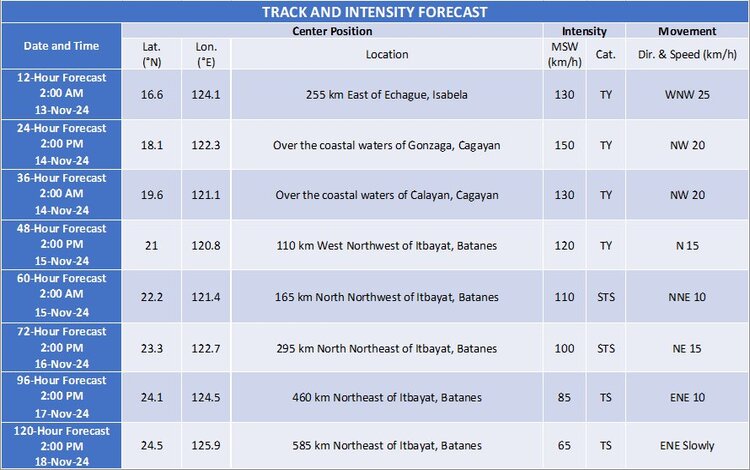
Typhoon Ofel is forecast to continue its west-northwest track over the Philippine Sea, making potential landfall along the eastern coast of Cagayan or Isabela tomorrow afternoon (November 14). After landfall, the typhoon will likely move through the Luzon Strait on Friday (November 15), potentially passing close to or over the Babuyan Islands before shifting northeastward on Saturday towards the waters east of Taiwan. While Ofel is anticipated to intensify further over the next 24 hours, making landfall at peak intensity, a weakening trend is expected to begin post-landfall and continue thereafter.

