The Philippine Atmospheric, Geophysical and Astronomical Services Administration (PAGASA) has issued a weather forecast for January 30, 2025, highlighting the influence of a shear line over the Visayas and the eastern section of Southern Luzon, as well as the Northeast Monsoon affecting the rest of Luzon.
Forecast Weather Conditions:
- Bicol Region, Eastern Visayas, Laguna, Quezon, Oriental Mindoro, Marinduque, Romblon, Aklan, and Capiz: These areas will experience cloudy skies accompanied by scattered rains and isolated thunderstorms due to the shear line. Residents are advised to remain vigilant as moderate to heavy rainfall and occasionally intense rainfall may lead to flash floods or landslides.
- Caraga, Davao de Oro, and Davao Oriental: Cloudy skies with scattered rains and thunderstorms are expected, influenced by the easterlies. The public should be cautious of potential floods or landslides resulting from moderate to occasionally heavy rainfall.
- Cagayan Valley, Cordillera Administrative Region, and Aurora: These regions will have cloudy skies with rains brought about by the Northeast Monsoon. There is a possibility of flash floods or landslides due to moderate to occasionally heavy rainfall.
- Metro Manila and the rest of Luzon: Partly cloudy to cloudy skies with isolated light rains are anticipated, also due to the Northeast Monsoon. No significant impacts are expected in these areas.
- The rest of the country: Partly cloudy to cloudy skies with isolated rain showers or thunderstorms are forecasted, caused by the easterlies. Residents should be aware of the potential for flash floods or landslides during severe thunderstorms.
Forecast Wind and Coastal Water Conditions:
- Northern Luzon and the eastern sections of Central Luzon, Southern Luzon, and Visayas: Expect strong to gale-force winds blowing from the east to northeast, resulting in rough to very rough coastal waters with wave heights ranging from 2.8 to 4.5 meters. Mariners are advised to exercise caution.
- The eastern section of Mindanao and the rest of Luzon: Moderate to strong winds from the northeast will prevail, with coastal waters expected to be moderate to rough, having wave heights between 1.5 to 3.7 meters.
- The rest of the country: Light to moderate winds blowing from the northeast to east are anticipated, leading to slight to moderate coastal waters with wave heights ranging from 0.6 to 2.1 meters.
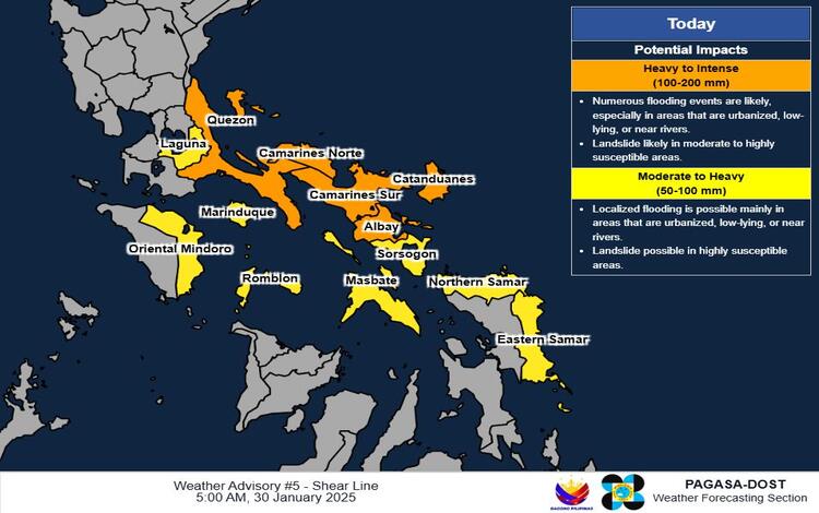
Heavy Rainfall Outlook Due to Shear Line:
Today (January 30):
- Heavy to Intense Rainfall (100-200 mm): Quezon, Camarines Norte, Camarines Sur, Catanduanes, and Albay.
- Moderate to Heavy Rainfall (50-100 mm): Laguna, Oriental Mindoro, Marinduque, Romblon, Sorsogon, Masbate, Northern Samar, and Eastern Samar.
Tomorrow (January 31):
- Heavy to Intense Rainfall (100-200 mm): Isabela.
- Moderate to Heavy Rainfall (50-100 mm): Cagayan, Aurora, and Quezon.