The Philippine Atmospheric, Geophysical, and Astronomical Services Administration (PAGASA) has issued a weather advisory for Tuesday, February 11, 2025, highlighting the influence of the shear line and the northeast monsoon on various regions of the country.
Weather Systems Affecting the Philippines
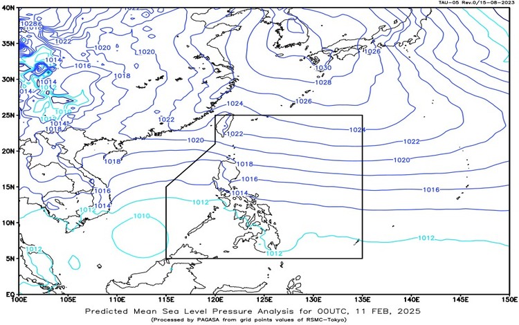
- Shear Line: This meteorological phenomenon, resulting from the convergence of warm and cold air masses, is currently impacting Southern Luzon and the Visayas.
- Northeast Monsoon (Amihan): The northeast monsoon continues to affect the rest of Luzon, bringing cooler temperatures and varying rainfall patterns.
Forecasted Weather Conditions
- Visayas, Bicol Region, MIMAROPA, Quezon, and Aurora: Residents in these areas can expect cloudy skies accompanied by scattered rains and isolated thunderstorms due to the shear line. PAGASA warns of potential flash floods or landslides resulting from moderate to heavy, and occasionally intense, rainfall.
- Caraga and Davao Regions: These regions will experience cloudy skies with scattered rains and thunderstorms, influenced by easterly winds. The public is advised to remain vigilant for possible flash floods or landslides during periods of moderate to heavy rainfall.
- Metro Manila, Cagayan Valley, Cordillera Administrative Region, and the rest of Central Luzon and CALABARZON: The northeast monsoon will bring cloudy skies with rains to these areas. There is a risk of flash floods or landslides due to moderate to occasionally heavy rainfall.
- The Rest of Luzon: Partly cloudy to cloudy skies with isolated light rains are anticipated, also due to the northeast monsoon. No significant weather-related impacts are expected in these regions.
- The Rest of Mindanao: Partly cloudy to cloudy skies with isolated rain showers or thunderstorms are forecasted, caused by easterlies. Residents should be cautious of possible flash floods or landslides during severe thunderstorms.
Marine Conditions
- Northern Luzon, Central Luzon, and the Eastern Sections of Southern Luzon and Visayas: Moderate to strong winds blowing from the northeast will prevail, resulting in moderate to rough coastal waters with wave heights ranging from 2.5 to 4.0 meters. Mariners are advised to exercise caution.
- The Rest of Luzon and Visayas: Similar wind conditions are expected, with coastal waters remaining moderate to rough and wave heights between 2.1 to 3.7 meters.
- Mindanao: Light to moderate winds from the east to northeast will lead to slight to moderate coastal waters, with wave heights ranging from 0.6 to 2.5 meters.
Heavy Rainfall Outlook Due to Shear Line
- Today (February 11):
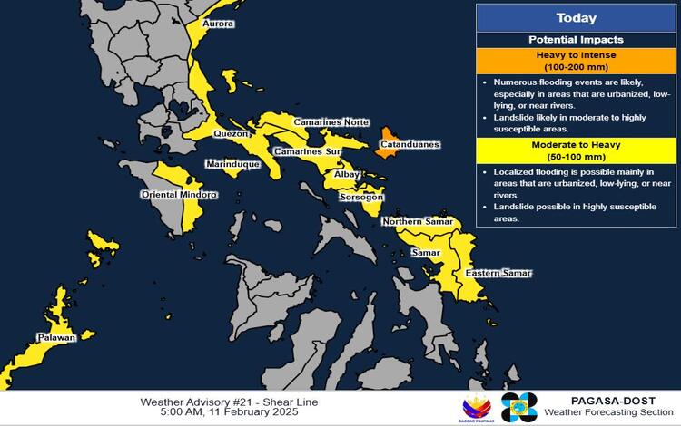
- Heavy to Intense Rainfall (100-200 mm): Catanduanes
- Moderate to Heavy Rainfall (50-100 mm): Aurora, Quezon, Marinduque, Oriental Mindoro, Palawan, Camarines Norte, Camarines Sur, Albay, Sorsogon, Northern Samar, Eastern Samar, and Samar
- Tomorrow (February 12):
- Moderate to Heavy Rainfall (50-100 mm): Cagayan, Isabela, Aurora, Quezon, and Camarines Norte
- Thursday (February 13):
- Moderate to Heavy Rainfall (50-100 mm): Cagayan and Isabela
PAGASA emphasizes that forecasted rainfall may be higher in mountainous and elevated areas. Additionally, significant antecedent rainfall may exacerbate the impacts in some regions.
Advisories
The public and disaster risk reduction and management offices are urged to take all necessary measures to protect life and property. PAGASA’s Regional Services Divisions may issue Heavy Rainfall Warnings, Rainfall/Thunderstorm Advisories, and other severe weather information specific to their areas of responsibility as appropriate.
The next Weather Advisory will be issued at 11:00 AM today unless significant changes occur.
Additional Information
It’s important to distinguish between a Heavy Rainfall Warning and a Weather Advisory. A Heavy Rainfall Warning provides forecasts for the next three hours and applies up to the municipal level. It is more precise as it utilizes Doppler radar technology to track real-time rainfall intensity, making it highly effective for immediate decision-making in flood-prone areas. In contrast, a Weather Advisory covers 24 hours but is issued only at the provincial level. It offers a broader outlook on potential weather disturbances but lacks the short-term accuracy of Heavy Rainfall Warnings.