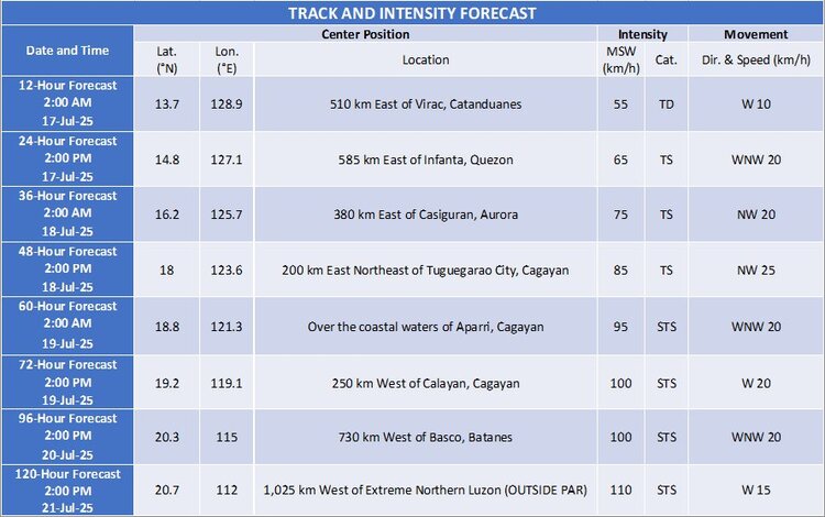
MANILA, Philippines — July 16, 2025. Tropical Depression Crising continues its west-southwestward track over the Philippine Sea, edging closer to Catanduanes, according to the Philippine Atmospheric, Geophysical and Astronomical Services Administration (PAGASA).
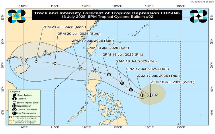
As of 4:00 PM Wednesday, Crising was spotted approximately 625 kilometers east of Virac, Catanduanes (13.5°N, 130.0°E). It carries maximum sustained winds of 45 km/h near the center and gusts of up to 55 km/h. The central pressure is measured at 1002 hPa, with strong winds extending up to 280 km from its core.
While no Tropical Cyclone Wind Signals (TCWS) are currently in effect, PAGASA warns that Signal No. 1 may be raised over portions of the Cagayan Valley region as early as tonight or early Thursday. Should Crising shift westward or widen in radius, Catanduanes may also be placed under Signal No. 1.
Forecasters do not discount the potential for higher signals to be hoisted in the coming days, with Wind Signal No. 3 or 4 possibly being issued depending on the system’s development.
The enhanced southwest monsoon, or habagat, continues to bring gusty conditions to several parts of the country. On Wednesday, Palawan, Siquijor, Bohol, Camiguin, Southern Leyte, Surigao del Norte, and Dinagat Islands experienced strong to gale-force winds. By Thursday, gusts are expected to affect Batangas, Quezon, the Bicol Region, MIMAROPA, parts of the Visayas, and Mindanao provinces, including Davao Oriental and Occidental.
On Friday, the southwest monsoon is forecast to impact a broader area, including Bataan, Metro Manila, CALABARZON, Basilan, Sulu, Tawi-Tawi, and northern Mindanao.
Mariners and coastal communities are also advised of rough seas in various areas. Waves reaching up to 2.5 meters are expected off the coasts of Palawan, Catanduanes, Zamboanga del Norte, and others. Moderate seas up to 2.0 meters are anticipated near Occidental Mindoro, Antique, and Eastern Samar.
Small vessels, including motor bancas, are advised to take precautions or suspend trips as conditions may be hazardous.