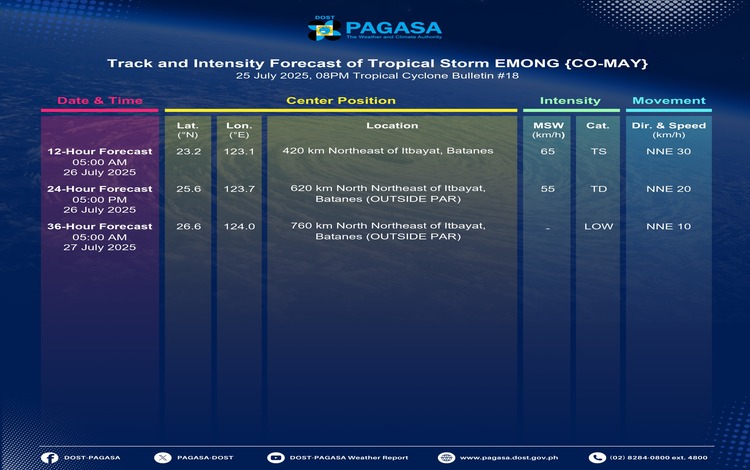
Tropical Storm Emong (international name: Co-may) is now moving away from Batanes, according to the Philippine Atmospheric, Geophysical and Astronomical Services Administration (PAGASA). As of 7:00 PM, the center of Emong was located 195 km east of Itbayat, Batanes, with maximum sustained winds of 85 km/h, gusts reaching up to 105 km/h, and a central pressure of 992 hPa. The storm is moving northeastward at a speed of 40 km/h.
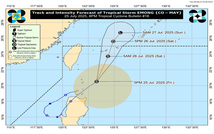
PAGASA noted that Emong is gradually exiting the country’s monitoring zone and is expected to leave the Philippine Area of Responsibility (PAR) by Saturday morning, July 26. However, despite its departure, the tropical storm continues to pose risks due to strong winds and enhanced southwest monsoon conditions.
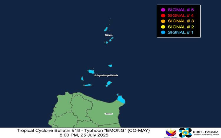
Wind Signals Still in Effect
Tropical Cyclone Wind Signal (TCWS) No. 1 remains raised over Batanes, Babuyan Islands, and the northeastern part of mainland Cagayan, particularly Santa Ana. These areas are experiencing strong winds with speeds ranging from 39 to 61 km/h. While the impacts are expected to be minimal to minor, local winds in coastal and mountainous areas could be stronger than forecast due to local terrain effects.
Heavy Rains and Severe Winds
PAGASA advises the public to refer to Weather Advisory No. 41 for rainfall updates. Emong, together with the enhanced Southwest Monsoon, will continue to bring rain and strong winds over various parts of Luzon, Visayas, and Dinagat Islands. Gale-force gusts are expected, especially in upland and coastal areas, with moderate to minor damage possible in exposed communities.
Hazardous Sea Conditions
Gale Warnings are in effect over the northern and eastern seaboards of Luzon, where wave heights may reach up to 5.5 meters. Sea travel remains risky across most of Northern Luzon and western seaboards down to Palawan. Mariners, especially those operating small vessels, are urged to remain in port or seek immediate shelter.
Outlook
Emong is forecast to weaken further due to an increasingly unfavorable environment and may degenerate into a remnant low by tomorrow evening, July 26, as it enters the East China Sea.