The Philippine Atmospheric, Geophysical and Astronomical Services Administration (PAGASA) reported that the low-pressure area east of Quezon has intensified into Tropical Depression Mirasol, the 13th tropical cyclone to enter the country this year.
As of 4:00 p.m. Tuesday, the center of Mirasol was located 210 kilometers east northeast of Infanta, Quezon (15.4°N, 123.5°E). It currently packs maximum sustained winds of 55 km/h near the center, gusts of up to 70 km/h, and a central pressure of 1006 hPa. The system is moving northwestward at 25 km/h, with strong winds extending outward up to 180 km from its center.
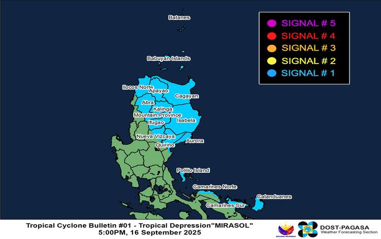
Tropical Cyclone Wind Signals in Effect
Tropical Cyclone Wind Signal (TCWS) No. 1 is hoisted over several provinces in Luzon, including Batanes, Cagayan with Babuyan Islands, Isabela, Quirino, parts of Nueva Vizcaya, northern and central Aurora, Apayao, Kalinga, Abra, Mountain Province, Ifugao, Ilocos Norte, Polillo Islands, Catanduanes, northern Camarines Norte, and northeastern Camarines Sur.
Under TCWS No. 1, winds of 39 to 61 km/h are expected within 36 hours, bringing minimal to minor threats to life and property. PAGASA warned that winds may be stronger in coastal and upland areas directly exposed to gusts.
Rainfall and Coastal Hazards
PAGASA also raised concerns about heavy rainfall, especially in affected areas of Luzon, which may trigger flash floods and landslides. The Southwest Monsoon (Habagat), enhanced by Mirasol, will bring gusty conditions tomorrow over Quezon, Camarines Norte, Marinduque, Romblon, southern Mindoro, and Panay Island. By Thursday, strong to gale-force winds may extend to Palawan, Ilocos Region, and Cagayan Valley.
Sea conditions will be moderate to rough, with waves reaching up to 2.5 meters along the seaboards of Cagayan, Babuyan Islands, Batanes, Isabela, Aurora, and Ilocos Norte. Small fishing boats and similar vessels are advised against venturing out to sea.
Track and Intensity Outlook
Based on the forecast track, Mirasol may make landfall over Isabela or northern Aurora by Wednesday morning. However, PAGASA noted a possible no landfall scenario if the cyclone shifts slightly northward, instead skirting the eastern coast of Northern and Central Luzon.
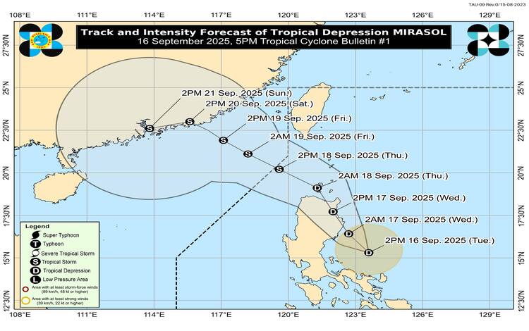
By Thursday, Mirasol is expected to exit the Philippine Area of Responsibility (PAR) via the Luzon Strait. It may weaken while crossing Luzon but is forecast to regain strength and potentially intensify into a tropical storm over the West Philippine Sea.
Residents in areas under wind signals are urged to monitor PAGASA’s bulletins and take precautionary measures against possible flooding, landslides, and rough sea conditions.