The Philippine Atmospheric, Geophysical and Astronomical Services Administration (PAGASA) reported on Tuesday evening, October 22, 2025, that Tropical Depression Salome has maintained its strength as it accelerates southward toward extreme Northern Luzon, bringing strong winds and rough sea conditions to affected areas.
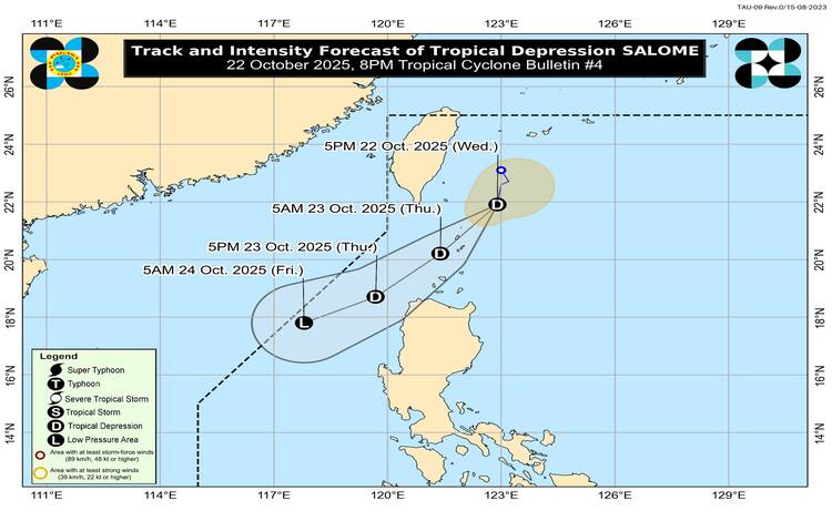
As of 7:00 PM, the center of Salome was estimated 160 kilometers northeast of Itbayat, Batanes (21.8°N, 122.9°E). The weather system carries maximum sustained winds of 55 km/h near the center and gustiness of up to 70 km/h, moving southward at 25 km/h. PAGASA noted that strong winds extend outward up to 200 kilometers from its center.
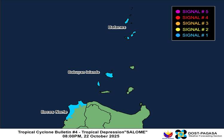
Tropical Cyclone Wind Signals Raised
Tropical Cyclone Wind Signal (TCWS) No. 1 remains hoisted over Batanes, the western portion of the Babuyan Islands (Calayan and Dalupiri Islands), and the northwestern part of Ilocos Norte (Bangui, Pagudpud, Burgos, Pasuquin, Bacarra, and Laoag City).
These areas may experience strong winds ranging from 39 to 61 km/h within the next 36 hours. PAGASA said the winds could bring minimal to minor threats to life and property, especially in coastal and upland communities.
While the system is expected to remain a tropical depression, the agency did not rule out the possibility of intensifying into a tropical storm, which could raise Signal No. 2 in some areas.
Wind and Rainfall Outlook
Local winds are expected to be stronger in coastal and elevated areas, with gusty conditions due to the northeasterly windflow affecting Northern Luzon.
Strong to gale-force winds are likely in Ilocos Norte, Ilocos Sur, Cagayan, Batanes, and the Babuyan Islands through Friday, October 24. PAGASA also advised residents to monitor its Weather Advisory No. 2 for rainfall updates related to Salome.
Hazardous Sea Conditions
A Gale Warning remains in effect over the seaboard of Extreme Northern Luzon, with sea conditions expected to reach up to 6 meters around Batanes and up to 4.5 meters around the Babuyan Islands.
PAGASA warned that sea travel is dangerous for all vessels, urging fishermen and small boat operators to stay in port until conditions improve.
Forecast Track
Salome is expected to move southwestward, possibly crossing or passing near Batanes and the Babuyan Islands tonight until tomorrow morning, before approaching Ilocos Norte by Wednesday afternoon. It is projected to weaken into a remnant low by Friday, though slight intensification remains possible.