November 2, 2025 — Manila, Philippines
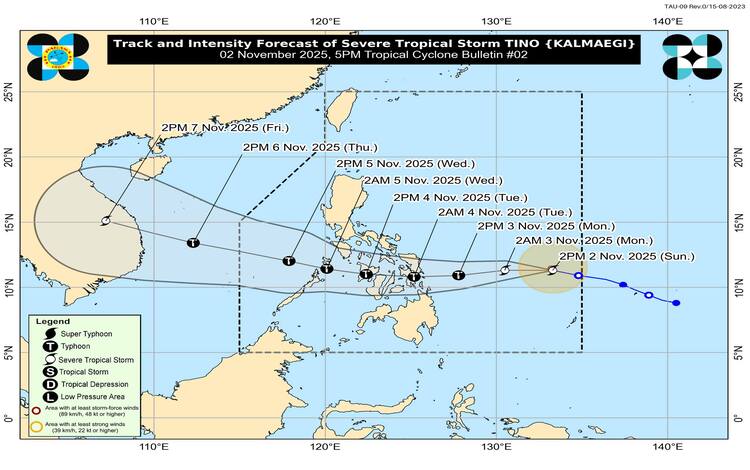
Severe Tropical Storm “Tino” (international name Kalmaegi) continues to gain strength as it barrels westward over the Philippine Sea, according to the Philippine Atmospheric, Geophysical and Astronomical Services Administration (PAGASA). As of 4:00 p.m., the storm’s center was estimated at 805 kilometers east of Eastern Visayas, packing maximum sustained winds of 95 km/h near the center and gustiness reaching 115 km/h. The system is currently moving west at 30 km/h with a central pressure of 990 hPa.
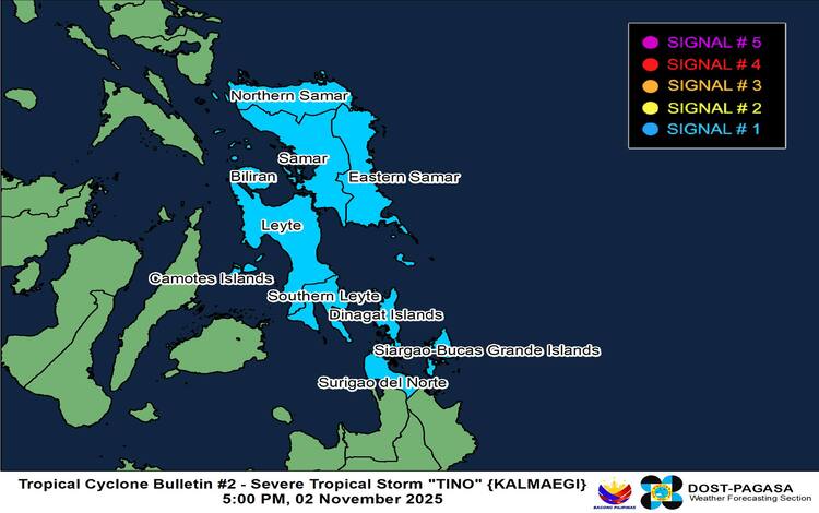
PAGASA said that Tino’s strong to storm-force winds extend outward up to 240 kilometers from the center. Tropical Cyclone Wind Signal (TCWS) No. 1 has been raised over parts of Eastern Visayas and northern Mindanao, including Eastern Samar, Northern Samar, Leyte, Southern Leyte, Biliran, Camotes Islands, Dinagat Islands, and Surigao del Norte. These areas may experience strong winds of 39 to 61 km/h within the next 36 hours, posing minimal to minor threats to life and property.
The weather bureau warned that Tino may further intensify into a typhoon within the next 24 hours and could reach peak intensity between 150 to 165 km/h before landfall. Rapid intensification is possible, and PAGASA has not ruled out the chance of Tino reaching the super typhoon category. Landfall is forecast either in Eastern Samar or the Dinagat Islands by late Monday evening, November 3, or early Tuesday morning, November 4.
Following landfall, the system is expected to cross the Visayas region and northern Palawan before exiting into the West Philippine Sea by Wednesday, November 5. Despite a slight weakening as it traverses land, Tino is forecast to remain at typhoon strength throughout its passage across the country.
Hazards and Warnings
PAGASA’s heavy rainfall advisory warns of widespread rains over Eastern Visayas, Bicol Region, and portions of Mindanao that could trigger flooding and landslides. Coastal areas in Sorsogon, Masbate, Samar provinces, Leyte, Cebu, Bohol, Negros, Capiz, Iloilo, and nearby islands face a high risk of life-threatening storm surges within the next 48 hours.
Sea conditions are expected to deteriorate rapidly. Very rough to high seas, reaching up to seven meters, will prevail over the eastern seaboards of Visayas and Caraga Region. Gale warnings are likely to be raised tonight, and all sea travel is strongly discouraged.
Meanwhile, the surge of the Northeast Monsoon (Amihan) will bring strong to gale-force winds across Luzon, including Metro Manila, starting Monday.
Preparedness Measures
Local governments across Visayas and northern Mindanao have been advised to implement early evacuation in flood-prone and coastal zones. PAGASA has also issued General Flood Advisories for CALABARZON, Bicol Region, Central and Eastern Visayas, and CARAGA.
Residents in affected regions are urged to stay alert for succeeding bulletins as Tino intensifies and approaches the Philippine landmass.