Tropical Storm Verbena continued to scale up its operational footprint early Wednesday, with the system demonstrating stronger wind dynamics as it advanced west-northwest across the Philippine Sea. Based on the 4:00 AM situational readout from PAGASA, the storm’s center was positioned approximately 130 km west of Coron, Palawan, sustaining maximum winds of 85 km/h and gusts reaching 105 km/h—clear indicators of an increasingly energized circulation.
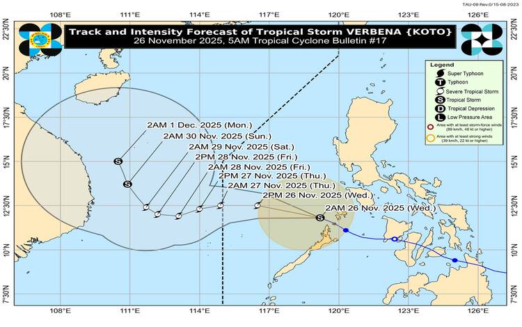
With a forward motion of 25 km/h, Verbena now carries expansive wind radii, extending strong to gale-force conditions up to 300 km from its core. This broadened influence has activated Tropical Cyclone Wind Signals over multiple areas, prompting local governments and response clusters to elevate readiness levels.
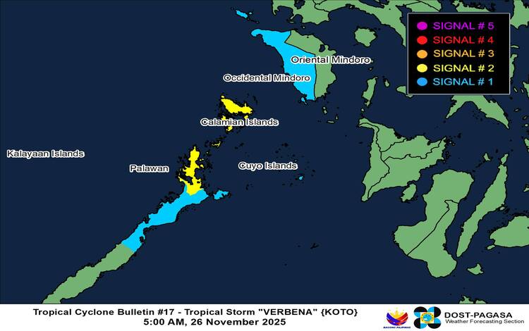
Wind Signals and Area Impact
Signal No. 2 remains hoisted over the Calamian Islands and the extreme northern portion of Palawan, including El Nido and Taytay. These zones are positioned for gale-force winds within the next 24 hours—an operational risk designation calling for proactive impact mitigation and continuity planning.
Signal No. 1 covers Occidental Mindoro and broader sectors of mainland Palawan, including Puerto Princesa City, Roxas, San Vicente, and island territories such as Cuyo and Kalayaan. While risks remain minimal to minor, local stakeholders are still advised to implement baseline safety protocols, especially across coastal communities.
Rainfall, Winds, and Spillover Effects
Although the cyclone isn’t crossing mainland Luzon, its synergistic interaction with the Northeast Monsoon is amplifying gusty conditions across most of the region. From today through tomorrow, strong to gale-force winds may be experienced even outside signal-raised areas, particularly in upland and coastal corridors.
PAGASA continues to flag heightened rainfall risks tied to both Verbena and the prevailing shear line, advising the public to monitor Weather Advisory No. 25 for tactical updates on possible flooding and landslides.
Challenging Sea Conditions
A Gale Warning remains active over the seaboards of Northern and Southern Luzon, and sea conditions are projected to range from rough to very rough across wide swaths of the archipelago. Wave heights may crest between 4.0 to 6.0 meters in several northern coastal zones, compelling authorities to recommend strict port stays for all vessel classes. Small craft operators, in particular, are strongly discouraged from navigating under these volatile conditions.
Track and Outlook
Forecast models position Verbena on a west-northwest track over the West Philippine Sea before shifting westward later today, skirting north of the Kalayaan Islands. The storm is expected to exit the Philippine Area of Responsibility by Thursday morning. Favorable environmental factors may escalate it to a severe tropical storm within the day. However, interaction with the strengthened Northeast Monsoon could induce weakening by tomorrow evening.
Stakeholders across Luzon and nearby maritime zones are encouraged to maintain alignment with PAGASA’s succeeding bulletins as the agency continues to refine its projections in response to evolving atmospheric data.