The Philippine Atmospheric, Geophysical and Astronomical Services Administration (PAGASA) released its latest bulletin on Tropical Depression AdaPH, internationally named Nokaen, at 5:00 a.m. on January 20, 2026. According to the weather agency, Ada continues to maintain its strength as it moves eastward over the Philippine Sea, while posing weather and marine hazards across large parts of the country due to its interaction with the Northeast Monsoon.
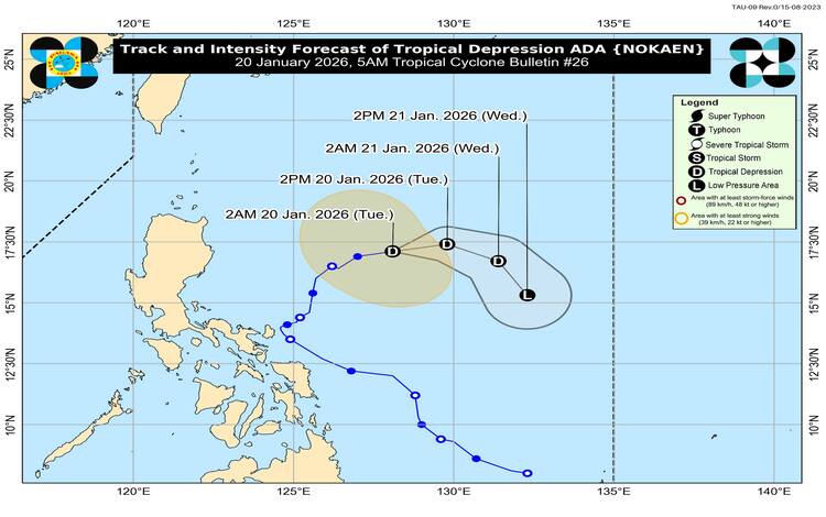
As of 4:00 a.m., the center of Tropical Depression Ada was located approximately 675 kilometers east of Casiguran, Aurora, at coordinates 17.1°N, 128.4°E. The system has maximum sustained winds of 55 kilometers per hour near the center, with gusts reaching up to 70 kilometers per hour. Its central pressure is estimated at 1000 hectopascals. Ada is currently moving eastward at a speed of 20 kilometers per hour, with strong winds extending outward up to 340 kilometers from its center.
Despite its presence over the Philippine Sea, PAGASA noted that no Tropical Cyclone Wind Signal is currently hoisted over any part of the country. However, residents are still advised to remain cautious as the enhanced Northeast Monsoon is expected to bring severe winds, particularly in coastal and upland areas exposed to strong gusts.
For January 20, strong to gale-force winds are forecast over Batanes, the Babuyan Islands, parts of Cagayan and Isabela, Ilocos Region, Aurora, CALABARZON, MIMAROPA, the Bicol Region, and portions of Eastern Visayas and Caraga. On January 21 and 22, these hazardous wind conditions may expand to include Metro Manila, Central Luzon, the Visayas, and several areas in Mindanao, including the Davao Region, Zamboanga Peninsula, and the Bangsamoro region.
PAGASA has also issued a Gale Warning for the northern seaboards of Northern Luzon. Sea conditions are expected to be very rough to rough, with waves reaching up to 5.0 meters along the seaboards of Batanes and the Babuyan Islands, and up to 4.5 meters in mainland Cagayan and Ilocos Norte. Sea travel remains risky for all types of vessels, and mariners are strongly advised to remain in port or seek safe harbor.
Looking ahead, Ada is forecast to continue moving generally eastward before turning south-southeastward through January 21. Continuous dry air intrusion from the Northeast Monsoon is expected to cause gradual weakening, and the system may downgrade into a low-pressure area by Wednesday, though earlier weakening remains possible.