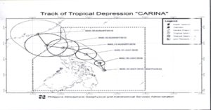
PAG-ASA advises fisherfolks to be on-guard because of Carina.
The Philippine Atmospheric, Geophysical and Astronomical Services Administration (PAG-ASA) advised the residents in the Bicol Region and Eastern Visayas following the developing of the Low Pressure Area (LPA) into a tropical depression Friday morning.

PAG-ASA confirmed that the cyclone is the third weather disturbance to enter the Philippine Area of Responsibility (PAR) this 2016 and it is named Tropical Cyclone Carina.
The country’s weather bureau said that the depression was last seen according to available data at 195 kilometers East of Borongan City, Eastern Samar.
It is moving Northwest toward at a speed of 11 kilometers per hour carrying maximum winds of 45 kilometers per hour near the center.
The estimated amount of rainfall if from moderate to heavy within the 300 kilometers diameter of the Tropical Depression.
Fisherfolks are being alerted against moderate to rough seas over the eastern seaboards of Luzon and Visayas.
Carina will bring moderate to heavy rains over Bicol region, Eastern Visayas and CARAGA region which may trigger flashfloods and landslides.
In the latest weather bulletin of PAG-ASA, Tropical Depression Carina is expected to be at 280 kilometers East of Virac, Catanduanes tomorrow morning.
On Sunday morning, it is forecast to be at 255 kilometers East of Casiguran, Aurora. On Monday morning, it is estimated to be at 50 kilometers North Northwest of Laoag City, Ilocos Norte while on Tuesday, it is expected to be at 430 kilometers West of Calayan Island, Cagayan.
It is forecast to be at 655 kilometers West Northwest of Itbayat, Batanes on Wednesday morning or 120 hours upon entry to the Philippine Area of Responsibility (PAR).
PAG-ASA issues no topical cyclone warning signal as of the moment. The weather agency appealed to the public and the disaster risk reduction and management council concerned to take appropriate actions and watch for the next weather bulletin to be issued at 11 PM.
