“Aghon” Slightly Weakens as It Crosses Ticao Island and Masbate City
The center of Tropical Depression Aghon was located over the coastal waters of Sibuyan Island, approximately at 12.5°N latitude and 122.9°E longitude. Aghon has shown signs of slight weakening, now exhibiting maximum sustained winds of 45 km/h near the center, gustiness of up to 70 km/h, and a central pressure of 1006 hPa. It is currently moving west-northwestward at a speed of 30 km/h.
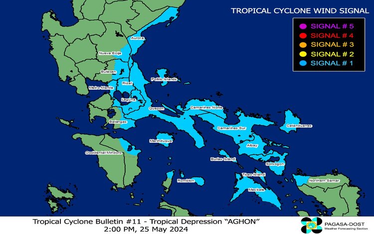
Tropical Cyclone Wind Signals in Effect
TCWS No. 1 is raised over the following areas due to the threat of strong winds:
- Luzon: Aurora, the eastern portion of Nueva Ecija, the eastern portion of Bulacan, Metro Manila, Quezon including Pollilo Islands, Romblon, Marinduque, Laguna, Rizal, Oriental Mindoro, Batangas, Sorsogon, Albay, Catanduanes, Camarines Sur, Camarines Norte, and Masbate including Ticao and Burias Islands.
- Visayas: The northern portion of Northern Samar and the northern portion of Samar.
This warning suggests a lead time of 36 hours, with expected wind speeds ranging from 39 to 61 km/h. Potential impacts include minimal to minor threats to life and property.
Hazards Affecting Land Areas
Heavy Rainfall Outlook
The forecast for accumulated rainfall from today to tomorrow noon includes:
- 100-200 mm: Quezon including Polillo Islands, the eastern portions of Laguna and Rizal, Marinduque, Romblon, and Bicol Region.
- 50-100 mm: Eastern portion of Isabela, Aurora, Metro Manila, the rest of Rizal, the rest of Laguna, and the northern portion of Western Visayas.
From tomorrow noon to Monday noon, the forecasted rainfall is:
- 100-200 mm: Quezon including Polillo Islands, Camarines Norte, Camarines Sur, and Catanduanes.
- 50-100 mm: Aurora, the rest of the Bicol Region, and the eastern portions of Isabela, Laguna, and Rizal.
Flooding and rain-induced landslides are possible, particularly in elevated or mountainous areas and localities with high susceptibility to these hazards.
Severe Winds
The wind signals indicate a general wind threat, with local winds potentially stronger in coastal and upland/mountainous areas. Minimal to minor impacts from strong winds are possible within areas under Wind Signal No. 1.
Additional areas in CALABARZON, MIMAROPA, and Central Luzon may be placed under Wind Signal No. 1 in the next bulletin, with the possibility of the highest Wind Signal No. 2 being issued during Aghon’s passage.
Hazards Affecting Coastal Waters
Today, Aghon will cause moderate to rough seas with waves ranging from 1.5 to 3.5 meters along the seaboards of Bicol Region, Quezon, the eastern seaboard of Eastern Visayas, and the western seaboard of Samar and Northern Samar. Mariners operating small vessels are advised to exercise caution and avoid navigating these conditions if possible.
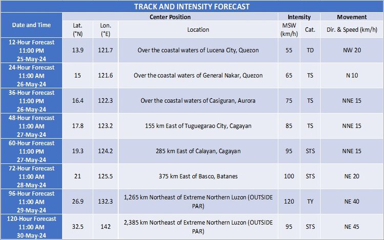
Track and Intensity Outlook
Aghon is forecast to move west-northwestward to northwestward over the Sibuyan Sea and Tayabas Bay, potentially making landfall over Marinduque within the next 12 hours. Further weakening into a Low-Pressure Area (LPA) is possible during this period. Afterward, it may move northward, with another potential landfall over Lucena City or Pagbilao, Quezon, and could emerge over Lamon Bay by tomorrow morning. Re-intensification to a tropical storm is possible by tomorrow morning.
By tomorrow afternoon or evening, Aghon is expected to recurve northeastward, potentially intensifying into a typhoon by Tuesday evening or Wednesday morning, and may exit the Philippine Area of Responsibility (PAR) by Tuesday.
Advisory
The public and disaster risk reduction and management offices are advised to take necessary measures to protect life and property. Residents in high-risk areas should follow evacuation and other instructions from local officials. Stay updated with the local PAGASA Regional Services Division for specific weather information.
Stay safe and informed by monitoring updates from PAGASA and local authorities.