“AGHON” MAINTAINS ITS STRENGTH AND IS NOW OVER THE COASTAL WATERS OF CATBALOGAN CITY, SAMAR
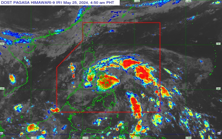
The center of Tropical Depression Aghon has been located over the coastal waters of Catbalogan City, Samar at 11.7°N, 124.9°E. The tropical depression maintains maximum sustained winds of 55 km/h near its center, with gustiness reaching up to 90 km/h, and a central pressure of 1004 hPa. Aghon is moving northwestward at a speed of 30 km/h.
Extent of Tropical Cyclone Winds:
The strong winds extend outward up to 140 km from the center, affecting several regions under Tropical Cyclone Wind Signals (TCWS) No. 1.
TCWS No. 1 is in effect in the following areas:
Luzon:
- The northern portion of Aurora (Casiguran, Dilasag)
- Polillo Islands
- The southern portion of Quezon (including areas such as Calauag, Guinayangan, Lopez, Buenavista, Catanauan, and others)
- The eastern portion of Romblon (Cajidiocan, Magdiwang, San Fernando)
- Camarines Norte, Camarines Sur, Catanduanes, Albay, Sorsogon, Masbate including Burias and Ticao Islands
Visayas:
- Northern Samar, Samar, Eastern Samar, Biliran, Leyte, Southern Leyte
- The extreme northern portion of Cebu (including San Remigio, Tabogon, City of Bogo, Medellin, Daanbantayan, Borbon)
- Camotes and Bantayan Islands
Mindanao:
- Dinagat Islands
HAZARDS AFFECTING LAND AREAS:
Heavy Rainfall Outlook:
Today:
- 100-200 mm: Albay, Sorsogon, Camarines Sur, Northern Samar, Samar, Eastern Samar, Biliran, and Leyte.
- 50-100 mm: Romblon, the southern portion of Quezon, the rest of Bicol Region, and the northern portions of Western Visayas and Cebu.
Tomorrow:
- 100-200 mm: Camarines Norte, Camarines Sur, and Catanduanes.
- 50-100 mm: Northern Samar, Polillo Islands, the rest of Bicol Region, and the southern portion of Quezon.
Rainfall will be higher in elevated or mountainous areas, potentially leading to flooding and rain-induced landslides, especially in areas already susceptible or that have received significant rainfall recently.
Severe Winds:
Minimal to minor impacts from strong winds are possible within the areas under Wind Signal No. 1. Winds will be slightly stronger in coastal and upland areas exposed to winds and less strong in sheltered areas.
The highest possible Wind Signal that may be issued during Aghon’s passage is Wind Signal No. 2.
HAZARDS AFFECTING COASTAL WATERS:
Today, Aghon will bring moderate to rough seas (1.5 to 3.5 meters) over the coastal waters along the seaboards of the Bicol Region, the southern seaboard of Quezon, the eastern seaboard of Eastern Visayas, the western seaboard of Samar and Northern Samar, and the eastern seaboard of the Caraga Region. Mariners, especially those with small vessels, are advised to take precautionary measures and avoid navigating in these conditions if possible.
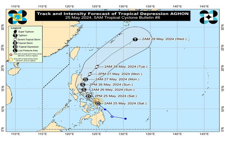
TRACK AND INTENSITY OUTLOOK:
Aghon is forecast to move generally northwestward over the Samar Sea, crossing the Bicol Peninsula between this afternoon and early tomorrow morning. It is expected to emerge over the waters north of the Camarines Provinces by tomorrow morning. During this period, Aghon may intensify into a tropical storm.
By tomorrow afternoon, Aghon is projected to start recurving towards the northeast. As it moves over the Philippine Sea, it is forecast to continuously intensify, potentially reaching typhoon category by Tuesday. Aghon may exit the Philippine Area of Responsibility (PAR) no earlier than Tuesday.
SYNOPSIS:
At 3:00 AM today, the center of Tropical Depression Aghon was estimated in the vicinity of Santa Rita, Samar (11.5°N, 125.1°E), with maximum sustained winds of 55 km/h near the center and gustiness up to 70 km/h, moving northwestward at 30 km/h.
FORECAST:
Eastern Visayas will experience rains with gusty winds due to TD Aghon. The rest of Visayas, Palawan including the Kalayaan Islands, and Occidental Mindoro will have cloudy skies with scattered rain showers and thunderstorms due to the trough of TD Aghon.
Moderate to strong winds from northeast to northwest will prevail over Eastern Visayas with moderate to rough seas. Light to moderate winds from northwest to southwest will prevail over the rest of Visayas, Palawan including Kalayaan Islands, and Occidental Mindoro with slight to moderate seas.
General Flood Advisories Issued at 6:00 AM, 25 May 2024:
- Region 4A (CALABARZON) GFA#1
- Region 4B (MIMAROPA) GFA#1
- Region 5 (Bicol Region) GFA#3
- Region 6 (Western Visayas) GFA#2
- Region 7 (Central Visayas) GFA#3
- Region 8 (Eastern Visayas) GFA#4
- Region 10 (Northern Mindanao) GFA#3
- Region 11 (Davao Region) GFA#3
- Region 13 (CARAGA) GFA#3
- BARMM GFA#2
Stay tuned for the next bulletin for further updates on Tropical Depression Aghon.