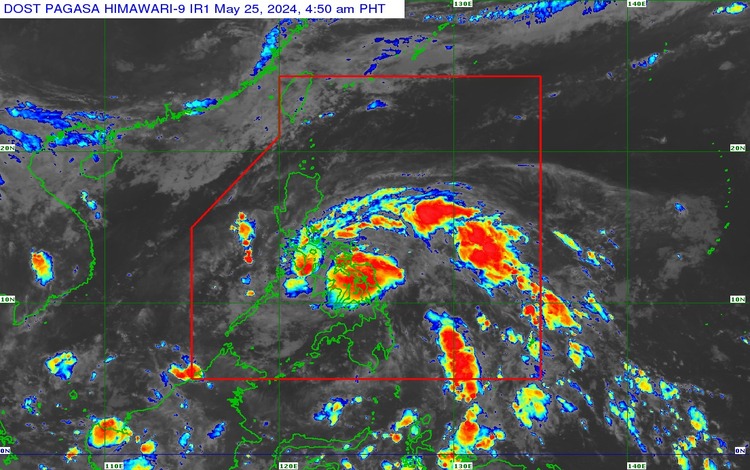
Twenty areas nationwide are now under Tropical Cyclone Wind Signal No. 1 due to Tropical Depression (TD) Aghon, the state weather bureau reported. The Philippine Atmospheric, Geophysical and Astronomical Services Administration (Pagasa), in the latest update, warned that the affected areas might experience wind speeds of up to 39-61 kilometers per hour (kph).
Affected Areas
Luzon:
- Sorsogon
- Albay
- Catanduanes
- Camarines Sur
- Camarines Norte
- Masbate, including Ticao Island and Burias Island
- Quezon (specific municipalities: Calauag, Guinayangan, Lopez, Buenavista, Catanauan, Mulanay, San Narciso, San Francisco, San Andres, Tagkawayan)
Visayas:
- Eastern Samar
- Samar
- Northern Samar
- Leyte
- Southern Leyte
- Biliran
- Cebu (specific municipalities: San Remigio, Tabogon, City of Bogo, Medellin, Daanbantayan, Borbon), including Camotes Islands and Bantayan Islands
- Bohol (specific municipalities: Pres. Carlos P. Garcia, Bien Unido, Trinidad, Anda, Candijay, Ubay, Mabini, Alicia, San Miguel, Talibon)
Mindanao:
- Dinagat Islands
- Surigao del Norte, including Siargao and Bucas Grande Islands
- Surigao del Sur
- Agusan del Sur (specific municipalities: Sibagat, City of Bayugan, Prosperidad, San Francisco, Rosario, Bunawan, Trento)
- Agusan del Norte
Current Position and Movement
As of the latest advisory, the center of TD Aghon was located approximately 135 kilometers northeast of Hinatuan, Surigao del Sur. It is moving in a west-northwestward direction at a speed of 30 kph.
Expected Impact
Pagasa cautioned residents in the affected areas to prepare for moderate to strong winds that could cause light damage to structures and vegetation. Coastal areas may experience rough seas, posing hazards to small seacraftsTropical Depression Aghon: 20 Areas Now Under Signal No. 1. Fishermen and those with small boats are advised to stay ashore until the weather improves.
In addition to the winds, TD Aghon is expected to bring moderate to heavy rains, which may lead to flash floods and landslides, particularly in areas that are prone to these hazards. Local government units are urged to implement necessary precautions and ensure the safety of their constituents.
Precautionary Measures
Authorities have advised the public to stay updated with the latest weather bulletins and heed the warnings and advisories issued by local disaster risk reduction and management councils. Residents in low-lying and mountainous areas are particularly encouraged to be vigilant against possible flooding and landslides.
Government Response
The National Disaster Risk Reduction and Management Council (NDRRMC) is coordinating with local government units (LGUs) for potential evacuations and preemptive measures. Emergency response teams and resources are being mobilized to ensure a swift response in the event of severe weather conditions.
Preparedness Tips
- Secure loose outdoor items and reinforce roofs and windows.
- Prepare an emergency kit with essentials such as food, water, medications, and important documents.
- Stay indoors and avoid unnecessary travel.
- Monitor local news and weather updates from reliable sources.
Conclusion
As TD Aghon continues, the situation remains fluid, and conditions can change rapidly. The public is encouraged to stay vigilant and prioritize safety to mitigate the impact of this weather disturbance. Pagasa will continue to monitor the situation and provide updates as necessary.