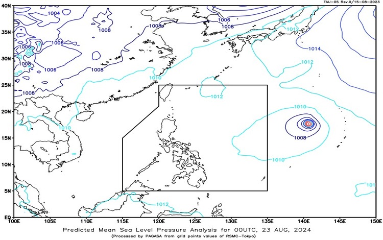
The Philippine Atmospheric, Geophysical, and Astronomical Services Administration (Pagasa) reported that the easterlies are currently affecting the eastern sections of Luzon and Visayas. Additionally, a Severe Tropical Storm, named Shanshan (international designation 2410), is located outside the Philippine Area of Responsibility (PAR), approximately 2,135 kilometers east of Central Luzon. Shanshan remains almost stationary with maximum sustained winds of 100 km/h near its center and gustiness reaching up to 125 km/h.
Forecast Weather Conditions
Zamboanga Peninsula, Palawan, Occidental Mindoro, Antique, Basilan, Sulu, and Tawi-Tawi are expected to experience cloudy skies with scattered rains and thunderstorms, primarily due to the southwest monsoon. Residents in these areas should be vigilant as moderate to heavy rains could lead to flash floods or landslides.
Metro Manila and the rest of the country will have partly cloudy to cloudy skies with isolated rain showers or thunderstorms. These localized thunderstorms may cause flash floods or landslides in certain areas, especially during severe weather conditions.
Forecast Wind and Coastal Water Conditions
In Luzon, light to moderate winds coming from the northeast to northwest will prevail, leading to slight to moderate coastal waters with wave heights ranging from 0.6 to 1.5 meters.
In Visayas and Mindanao, light to moderate winds from the southwest will be the predominant wind direction. Coastal waters in these areas are expected to be slight to moderate, with wave heights also between 0.6 to 1.5 meters.
Temperature and Humidity Extremes
For the 24 hours ending at 8:00 PM yesterday, temperatures across the country ranged from a minimum of 25.5°C recorded at 6:15 AM to a maximum of 34.4°C recorded at 1:00 PM. Relative humidity varied between a low of 57% at 1:00 PM and a high of 88% at 5:00 AM.
Severe Tropical Storm Shanshan (2410)
While Severe Tropical Storm Shanshan is currently outside PAR, it remains a weather system to monitor closely. Should it change its course or intensity, it may influence the weather patterns over the country, particularly in the eastern regions. However, for now, the primary weather influence over the Philippines remains the southwest monsoon and the easterlies.
Residents in affected areas are advised to stay updated with the latest weather bulletins and take necessary precautions, especially in regions prone to flash floods and landslides.