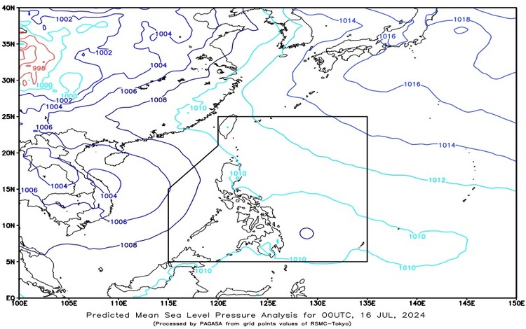
LPA and Southwest Monsoon Bring Rainy Conditions At 3:00 AM today, a Low-Pressure Area (LPA) was estimated to be 310 km East Northeast of Davao City (8.3°N, 128.2°E). The southwest monsoon continues to affect the western sections of Southern Luzon and Mindanao, bringing a mix of weather conditions across the country.
Forecast Weather Conditions
Eastern Visayas, Caraga, and Davao Region: Expect cloudy skies with scattered rain showers and thunderstorms due to the LPA. These conditions may lead to flash floods or landslides due to moderate to heavy rains at times.
Palawan: Cloudy skies with scattered rain showers and thunderstorms are forecasted, attributed to the southwest monsoon. Like the aforementioned areas, Palawan is also at risk of flash floods or landslides from moderate to heavy rains.
Metro Manila, Zamboanga Peninsula, BARMM, SOCCSKSARGEN, Cavite, Batangas, Bataan, and Occidental Mindoro: These regions will experience partly cloudy to cloudy skies with isolated rain showers or thunderstorms caused by the southwest monsoon. Severe thunderstorms in these areas could result in flash floods or landslides.
Rest of the Country: Partly cloudy to cloudy skies with isolated rain showers or thunderstorms are expected due to localized thunderstorms. There is a potential risk of flash floods or landslides during severe thunderstorms.
Forecast Wind and Coastal Water Conditions
Western Sections of Luzon and Visayas: Winds will be moderate to strong, coming from the southwest to southeast, with coastal waters expected to be moderate to rough (1.2 to 2.8 meters).
Mindanao: Light to moderate winds from the northeast to northwest are anticipated, with slight to moderate coastal waters (0.6 to 2.5 meters).
Rest of the Country: Light to moderate winds from the east to southeast will prevail, with slight to moderate coastal waters (0.6 to 2.1 meters).
Additional Forecast
The Eastern and Central Visayas, Palawan including Kalayaan Islands, and Occidental Mindoro will have cloudy skies with scattered rain showers and thunderstorms due to the combined effects of the southwest monsoon and the LPA. The rest of the Visayas will experience partly cloudy to cloudy skies with isolated rain showers and/or thunderstorms, primarily due to the southwest monsoon. Moderate to strong winds from the southwest to southeast will prevail over Palawan and Occidental Mindoro, leading to moderate to rough seas. Light to moderate winds from the southwest to southeast will affect the entire Visayas, resulting in light to moderate seas.
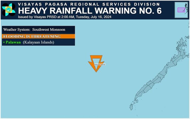
Heavy Rainfall Warning
An Orange Warning Level has been issued for Palawan (Kalayaan Islands), indicating that flooding is threatening in low-lying areas and landslides are possible in mountainous regions. The public, along with the disaster risk reduction and management council, are advised to take appropriate actions, monitor the weather conditions closely, and await the next advisory, scheduled for release at 5:00 AM.
Stay safe and vigilant as these weather disturbances progress.