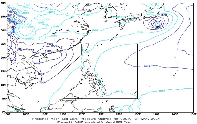
SYNOPSIS: A frontal system is currently affecting Extreme Northern Luzon. Additionally, an active tropical cyclone is located outside the Philippine Area of Responsibility (PAR). As of 3:00 AM today, the tropical depression is positioned approximately 955 km west of Northern Luzon, with coordinates at 17.8°N, 111.5°E. This system is exhibiting maximum sustained winds of 45 km/h, gustiness up to 55 km/h, and is moving west-northwestward at 10 km/h.
Forecast Weather Conditions
Area: Batanes and Babuyan Islands
- Weather Condition: Cloudy skies with scattered rain showers and thunderstorms.
- Caused By: Frontal System.
- Impacts: Residents in these areas should be prepared for possible flash floods or landslides due to moderate to at times heavy rains.
Area: Metro Manila and the Rest of the Country
- Weather Condition: Partly cloudy to cloudy skies with isolated rain showers or thunderstorms.
- Caused By: Localized Thunderstorms.
- Impacts: There is a potential for flash floods or landslides during severe thunderstorms. People should remain vigilant, especially in flood-prone or landslide-prone areas.
Forecast Wind and Coastal Water Conditions
Area: The Whole Country
- Wind Speed: Light to Moderate.
- Wind Direction: Southeast to South.
- Coastal Waters: Conditions will range from slight to moderate, with wave heights between 0.6 to 2.5 meters.
Detailed Regional Forecast
The Whole Visayas, Palawan Including Kalayaan Islands, and Occidental Mindoro
- Weather Condition: These regions will experience partly cloudy to cloudy skies with isolated rain showers or thunderstorms.
- Caused By: Localized Thunderstorms.
General Advisory
Given the current weather conditions, residents across the affected regions are advised to take the following precautions:
- For Areas Affected by the Frontal System (Batanes and Babuyan Islands):
- Stay updated with the latest weather bulletins and heed any warnings issued by local authorities.
- Prepare for possible flash floods and landslides, especially in low-lying and mountainous areas.
- Ensure that emergency kits are ready and that evacuation plans are in place.
- For Areas with Localized Thunderstorms (Metro Manila and the Rest of the Country):
- Be cautious of sudden heavy rains that may trigger flash floods or landslides.
- Avoid outdoor activities during thunderstorms to minimize the risk of accidents caused by lightning or strong winds.
- Monitor local news for weather updates and advisories.
- For Coastal and Marine Activities:
- Mariners should exercise caution when navigating coastal waters, especially when moderate waves are expected.
- Small sea vessels are advised to remain close to shore and avoid venturing into deeper waters during adverse weather conditions.
By staying informed and prepared, we can mitigate the impacts of these weather disturbances. Keep safe and stay alert for any further updates.