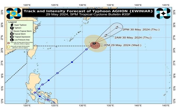
As of 4:00 PM today, Typhoon AGHON has moved outside the Philippine Area of Responsibility (PAR), with its center estimated at 1,225 kilometers east-northeast of Extreme Northern Luzon, positioned at 26.0°N latitude and 132.4°E longitude. Currently, AGHON exhibits maximum sustained winds of 120 km/h near its center, gustiness reaching up to 150 km/h, and a central pressure of 975 hPa. It is moving northeastward at a speed of 35 km/h, with strong typhoon-force winds extending outwards up to 260 km from its center.
Intensity and Movement
Typhoon AGHON is advancing northeastward at a steady pace of 35 km/h. It is not expected to directly impact the Philippines with significant rainfall in the next three days. However, the Southwesterly Windflow, partly influenced by AGHON, will induce moderate to heavy rains over the western parts of Northern Luzon, Central Luzon, and MIMAROPA until tomorrow. The affected areas should refer to Weather Advisory No. 6 issued at 11:00 AM today for detailed information.
Wind and Rainfall Outlook
The Southwesterly Windflow will also cause occasional gusty conditions over several areas in the next three days. These areas include:
- Today: Batanes, Ilocos Region, Zambales, Bataan, northern Aurora, southern mainland Quezon, Polillo Islands, Palawan, Lubang Islands, Romblon, Marinduque, and Camarines Norte.
- Tomorrow: Batanes, Ilocos Region, Zambales, Bataan, Lubang Islands, and Kalayaan Islands.
- Friday: Batanes and Ilocos Region.
Residents in these regions, particularly those in coastal and upland/mountainous localities, should prepare for gusty conditions and potential disruptions.
Coastal Waters and Marine Conditions
Mariners are advised to take precautionary measures as the Southwesterly Windflow, influenced by AGHON and the Frontal System, will bring moderate to rough seas (with waves ranging from 1.0 to 3.0 meters) over the coastal waters of Batanes. Motorbanca operators and those with similarly-sized vessels should exercise caution and, if possible, avoid navigating these waters, especially if they are inexperienced or operating inadequately equipped vessels.
Track and Intensity Outlook
AGHON is forecasted to continue its northeastward trajectory, moving over the sea area south of Japan. The typhoon is expected to gradually weaken due to increasingly hostile environmental conditions and begin transitioning into a post-tropical system as it interacts with the mid-latitude environment.
Advisory and Preparedness
Given these developments, the public and disaster risk reduction and management offices are urged to take all necessary measures to safeguard life and property. Residents in highly susceptible areas should heed evacuation orders and other instructions from local officials. For ongoing updates on heavy rainfall, thunderstorms, and other severe weather conditions specific to your area, monitor the advisories issued by your local PAGASA Regional Services Division.
Stay informed and prepared to ensure safety during these weather conditions.