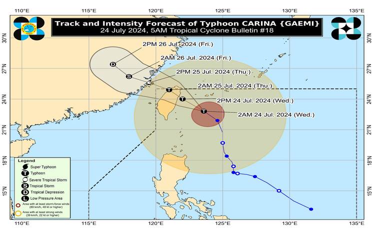
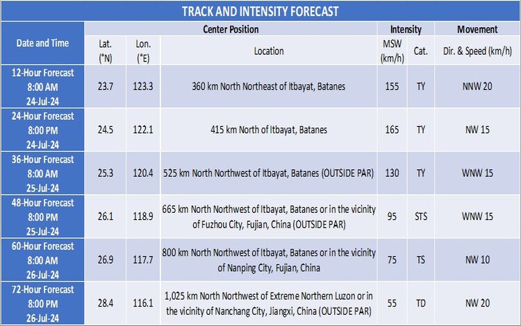
Typhoon Carina (international name: GAEMI) has intensified as it moves northwestward toward Taiwan. The center of the typhoon’s eye is located approximately 290 kilometers northeast of Itbayat, Batanes, with coordinates at 22.9°N, 123.5°E. Carina has maximum sustained winds of 155 km/h near the center, gusts reaching up to 190 km/h, and a central pressure of 950 hPa. The typhoon is advancing at a speed of 25 km/h.
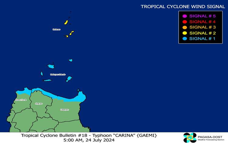
Tropical Cyclone Wind Signals (TCWS) in Effect
- TCWS No. 2: Batanes
- Wind Threat: Gale-force winds
- Warning Lead Time: 24 hours
- Wind Speeds: 62 to 88 km/h (Beaufort scale 8 to 9)
- Potential Impacts: Minor to moderate threat to life and property
- TCWS No. 1: Babuyan Islands, northern portions of Cagayan and Ilocos Norte
- Wind Threat: Strong winds
- Warning Lead Time: 36 hours
- Wind Speeds: 39 to 61 km/h (Beaufort scale 6 to 7)
- Potential Impacts: Minimal to minor threat to life and property
Heavy Rainfall Outlook
Today, the typhoon is expected to bring 50-100 mm of rainfall over Batanes and Babuyan Islands, with higher amounts in elevated or mountainous regions. This could lead to flooding and landslides, especially in areas that have experienced heavy rainfall in recent days. The Southwest Monsoon, enhanced by Carina, will also bring moderate to intense rainfall over parts of western Luzon through Friday.
Severe Winds and Coastal Hazards
The wind signals indicate strong to gale-force winds, with minor to moderate impacts expected in areas under TCWS No. 2. Minimal to minor impacts are anticipated in regions under TCWS No. 1. The enhanced Southwest Monsoon will also cause strong gusts in various areas, including Ilocos Region, Cordillera Administrative Region, and Metro Manila, among others, from today through Friday.
Gale warnings are in effect for the coastal waters of Batanes, Babuyan Islands, and northern Cagayan, making sea travel risky for small seacrafts. Rough seas, with wave heights between 2.5 to 4.0 meters, are expected over the seaboards of Northern and Central Luzon, and moderate to rough seas over Southern Luzon and Visayas.
Track and Intensity Outlook
Typhoon Carina is forecast to make landfall over northern Taiwan this afternoon or early evening. It will then cross Taiwan and exit the Philippine Area of Responsibility (PAR) tonight or early tomorrow morning, continuing towards southeastern China. Carina is expected to reach peak intensity before landfall in Taiwan but will weaken as it crosses the island’s rugged terrain.
Public Advisory
Residents and disaster risk reduction offices are advised to take necessary precautions to protect life and property. Those in highly susceptible areas should follow evacuation orders and other instructions from local authorities. Stay tuned to local advisories for updates on heavy rainfall warnings and other severe weather information.
Please stay safe and remain vigilant as Typhoon Carina continues its course toward Taiwan and beyond.