Issued at 11:00 AM, 23 October 2024
Valid for broadcast until the next bulletin at 2:00 PM today
The Philippine Atmospheric, Geophysical, and Astronomical Services Administration (Pagasa) has released its latest advisory on Typhoon KristinePH (Trami), which has slightly accelerated while maintaining its strength as it continues to move across the sea east of Aurora. As of 10:00 AM today, the center of Typhoon Kristine was located 200 kilometers east of Casiguran, Aurora, or approximately 255 kilometers east of Baler, Aurora (16.1°N, 124.0°E).
Current Intensity and Movement
Typhoon Kristine remains a significant weather system with maximum sustained winds of 85 km/h near the center and gusts reaching up to 105 km/h. Its central pressure stands at 985 hPa. The storm is moving north-northwestward at 30 km/h, with strong to gale-force winds extending outward up to 850 kilometers from the center.
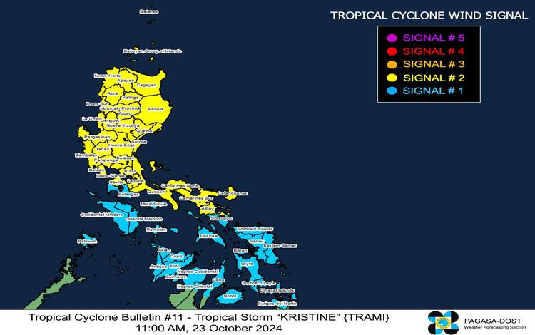
Tropical Cyclone Wind Signals (TCWS) in Effect
Pagasa has raised several tropical cyclone wind signals across affected regions:
- TCWS No. 2
Areas under Signal No. 2 are warned of gale-force winds ranging from 62 to 88 km/h. The lead time for these winds is approximately 24 hours, and potential impacts could range from minor to moderate threats to life and property. This signal covers a large portion of Luzon, including:- Ilocos Norte, Ilocos Sur, La Union, Pangasinan, Apayao, Abra, Kalinga, Mountain Province, Ifugao, Benguet, Cagayan including Babuyan Islands, Isabela, Quirino, Nueva Vizcaya, Aurora, Nueva Ecija, Bulacan, Tarlac, Pampanga, Zambales, Bataan, Metro Manila, Cavite, Laguna, Rizal, Quezon including Polillo Islands, Camarines Norte, Camarines Sur, Catanduanes, Albay, and the northeastern portion of Sorsogon.
- TCWS No. 1
Areas under Signal No. 1 are advised to prepare for strong winds between 39 and 61 km/h, with a warning lead time of 36 hours. These winds pose minimal to minor threats to life and property. This signal covers:- Parts of Luzon: Batanes, Batangas, Occidental Mindoro including Lubang Islands, Oriental Mindoro, Marinduque, Romblon, Calamian Islands, the rest of Sorsogon, and Masbate including Ticao and Burias Islands.
- Parts of Visayas: Aklan, Capiz, Antique, Iloilo, Guimaras, the northern portions of Negros Occidental and Negros Oriental, the northern and central portions of Cebu, Bantayan Islands, Camotes Islands, Bohol, Eastern Samar, Northern Samar, Samar, Leyte, Biliran, and Southern Leyte.
- Parts of Mindanao: Dinagat Islands and Surigao del Norte including Siargao and Bucas Grande.
Other Hazards Affecting Land Areas
- Heavy Rainfall
Heavy rainfall is expected in areas along the path of the typhoon. The public is urged to refer to Weather Advisory No. 12 for detailed information regarding rainfall predictions. - Severe Winds
Strong winds are expected, with coastal and upland areas likely to experience slightly stronger gusts. Moderate impacts from gale-force winds are possible in areas under TCWS No. 2, while minimal impacts are expected in areas under TCWS No. 1. - Coastal Inundation and Storm Surge
There is a significant risk of life-threatening storm surges within the next 48 hours over low-lying coastal areas of Ilocos Norte, Ilocos Sur, La Union, Pangasinan, Cagayan, Isabela, Zambales, Aurora, Camarines Sur, and Catanduanes. Residents in these areas are urged to take precautionary measures and monitor local advisories.
Hazards Affecting Coastal Waters
A gale warning is in effect for the seaboards of Luzon and Visayas. Sea conditions will be hazardous for all types of vessels, with waves reaching up to 8.0 meters in some areas, particularly the seaboards of Cagayan Valley, Ilocos Region, and Zambales. Mariners are advised to remain in port or seek shelter immediately.
Sea Conditions (24-Hour Outlook)
- Up to 8.0 meters: Cagayan Valley, Ilocos Region, and Zambales
- Up to 6.0 meters: Aurora, Polillo Islands, Camarines Norte, Catanduanes
- Up to 5.0 meters: Batangas, Lubang Islands
- Up to 4.5 meters: Cavite, Occidental Mindoro, Calamian Islands
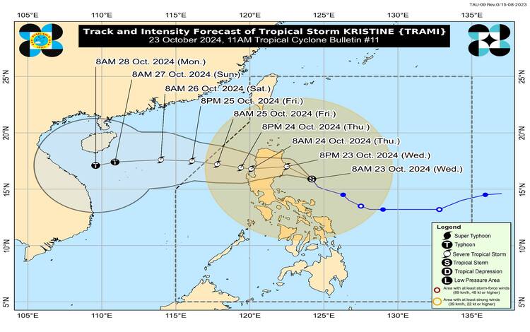
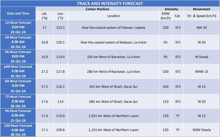
Track and Intensity Outlook
Typhoon Kristine is forecast to move northwestward over the next 12 hours before turning westward, making landfall over Isabela tonight. It will cross Northern Luzon and re-emerge over the waters west of the Ilocos Region by tomorrow morning. Kristine is expected to intensify into a severe tropical storm before landfall, although slight weakening is anticipated as it traverses the mountainous regions of Northern Luzon.
The typhoon may exit the Philippine Area of Responsibility (PAR) by Friday, 25 October, but re-intensification could occur once it moves over the West Philippine Sea.
Public Advisory
Pagasa advises all concerned residents and disaster management offices to take the necessary precautions to protect life and property. Those in areas highly susceptible to the impacts of the typhoon, particularly flooding, landslides, and storm surges, are urged to follow local evacuation orders and stay updated through Pagasa’s regional services. The next advisory will be issued at 2:00 PM today.