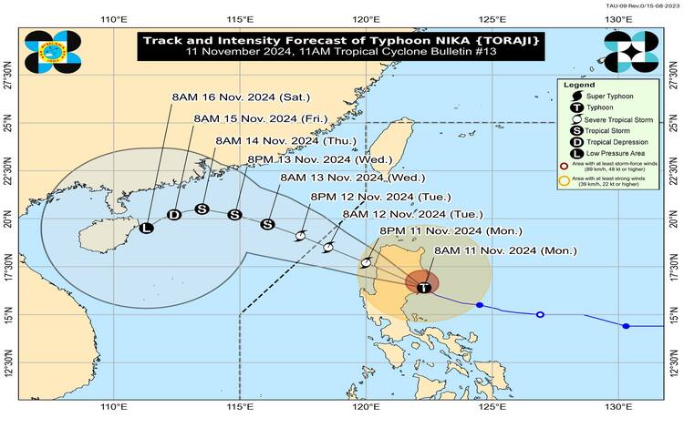
11 November 2024 – Typhoon NIKA has made landfall over Dilasag, Aurora, as it moves through northern Luzon. The Philippine Atmospheric, Geophysical, and Astronomical Services Administration (PAGASA) provided an update at 11:00 AM, warning of potential severe impacts due to the strong winds, heavy rains, and rough seas that the typhoon brings.

Current Location and Movement
As of 10:00 AM, Typhoon NIKA was located in the vicinity of San Agustin, Isabela, at 16.5°N, 121.8°E. It has sustained winds of 130 km/h near the center, gusts up to 180 km/h, and a central pressure of 965 hPa. The typhoon is moving northwest at a speed of 25 km/h and is expected to continue its path through northern Luzon before moving toward the West Philippine Sea later today.
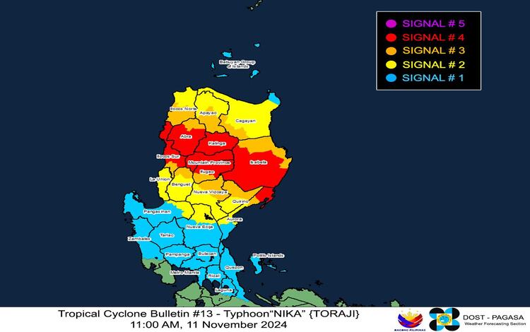
Tropical Cyclone Wind Signals (TCWS) in Effect
PAGASA has raised several Tropical Cyclone Wind Signals across northern Luzon, with TCWS No. 4, indicating typhoon-force winds, over several areas in Luzon. The following TCWS are currently in effect:
- TCWS No. 4: Covers areas in the northernmost portion of Aurora, southern Isabela, Kalinga, Mountain Province, and parts of Ifugao, Abra, and Ilocos Sur. This signal represents a significant to severe threat to life and property, with wind speeds from 118 to 184 km/h expected.
- TCWS No. 3: Includes parts of central Aurora, Quirino, Nueva Vizcaya, Cagayan, Apayao, Benguet, and additional areas in Ilocos Norte and Ilocos Sur. Winds of 89 to 117 km/h pose a moderate to significant threat to life and property.
- TCWS No. 2: This warning level applies to more extensive parts of Cagayan, Nueva Vizcaya, Quirino, Apayao, Benguet, Ilocos Norte, La Union, Pangasinan, and parts of Aurora and Nueva Ecija. Wind speeds range from 62 to 88 km/h, with a minor to moderate threat to life and property.
- TCWS No. 1: Extends to the rest of northern Luzon, including the Babuyan Islands, parts of Cagayan, Pangasinan, Aurora, Nueva Ecija, Bulacan, Pampanga, Tarlac, Zambales, Metro Manila, Rizal, eastern Laguna, and Quezon, including Polillo Islands. Wind speeds of 39 to 61 km/h may cause minimal to minor impacts.

Heavy Rainfall and Severe Winds
PAGASA’s Heavy Rainfall Advisory No. 13, issued at 11:00 AM, warns of widespread rain and thunderstorms in affected areas. Coastal and mountainous regions are particularly vulnerable, with potential landslides and flash floods in low-lying areas. PAGASA advises communities to remain vigilant and take necessary precautions, as rainfall can reach moderate to heavy levels even outside the typhoon’s direct path.
Severe winds are expected to impact areas with TCWS No. 4. Additionally, coastal and mountainous regions exposed to the typhoon’s path may experience slightly enhanced winds. Winds are expected to subside once Typhoon NIKA exits the landmass.
Coastal and Maritime Hazards
Coastal Inundation and Storm Surge: PAGASA warns of moderate to high risks of storm surge over the next 48 hours, especially in low-lying areas of Ilocos Norte, Ilocos Sur, La Union, Pangasinan, Cagayan, Isabela, Zambales, Aurora, Quezon (including Polillo Islands), Camarines Norte, and Camarines Sur. A Storm Surge Warning No. 7, issued earlier at 8:00 AM, highlights these risks, urging residents in these regions to evacuate or relocate to safer ground.
Gale Warning for Coastal Waters: Gale conditions affect the eastern seaboard of Luzon and the northern and western seaboards of northern Luzon, with waves reaching up to 8.0 meters in Isabela and northern Aurora, 5.5 meters in Aurora, and 5.0 meters along the Ilocos coastlines. Sea travel remains dangerous, with PAGASA advising mariners, especially those in smaller vessels, to remain in port.
Sea Condition Outlook: In the next 24 hours, the following coastal areas will experience dangerous sea conditions:
- Very Rough Seas: Isabela, Aurora, Cagayan, Ilocos Norte, and Ilocos Sur, with waves up to 8.0 meters.
- Rough Seas: Babuyan Islands, Batanes, and the Ilocos region, with waves up to 4.0 meters.
PAGASA has cautioned against any form of sea travel due to the risks posed by high waves and strong winds, particularly for small fishing boats and motorbancas.
Forecast Track and Expected Impact
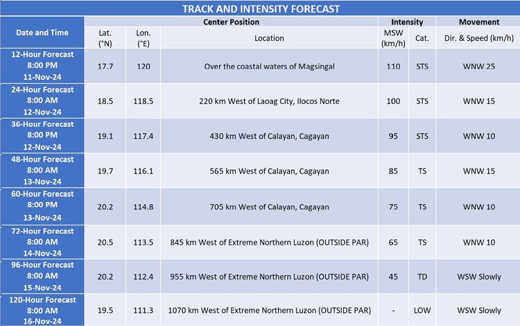
Typhoon NIKA is expected to traverse northern Luzon today, reaching the West Philippine Sea by this afternoon or evening. According to PAGASA, the typhoon is likely to continue its west-northwest track and exit the Philippine Area of Responsibility by the morning or afternoon of 12 November. Despite the typhoon’s projected movement away from Luzon, areas outside the central forecast cone are still likely to feel the effects of strong winds and heavy rainfall. Following its exit from PAR, NIKA will move over the West Philippine Sea, gradually intensifying before heading southwestward on Friday, 15 November.

Preparations and Precautions
Local governments and disaster response teams are on alert to assist with evacuations, particularly in coastal and flood-prone areas. Residents are advised to monitor PAGASA updates, prepare emergency kits, and secure loose items around homes to minimize damage from strong winds. The public is encouraged to avoid outdoor activities and stay indoors, especially in areas where TCWS No. 3 and No. 4 are in effect.
