The Philippine Atmospheric, Geophysical, and Astronomical Services Administration (Pagasa) has issued its latest advisory on Severe Tropical Storm Kristine, locally known as “Trami.” As of 4:00 PM, the storm’s center was spotted over the coastal waters of Santa Lucia, Ilocos Sur (17.1°N, 120.2°E), packing maximum sustained winds of 95 km/h and gusts up to 145 km/h. The storm is moving slowly westward.
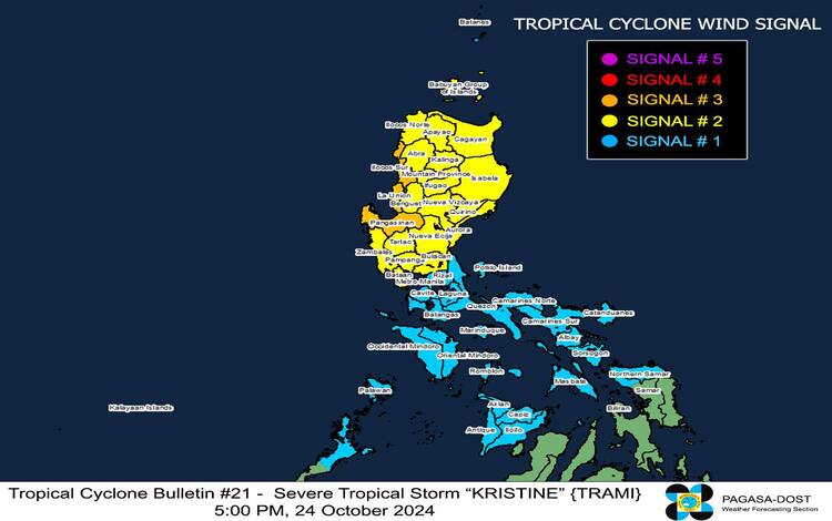
Current Wind Signals
Pagasa has raised Tropical Cyclone Wind Signals (TCWS) over various regions as Kristine threatens the country:
- TCWS No. 3: Ilocos Sur, La Union, Pangasinan
Storm-force winds (89-117 km/h), with potential impacts including moderate to significant threats to life and property. These areas are advised to brace for strong winds within the next 18 hours. - TCWS No. 2: Cagayan, Babuyan Islands, Isabela, Quirino, Nueva Vizcaya, and several other provinces
Gale-force winds (62-88 km/h) may cause minor to moderate damage over the next 24 hours. Residents should secure loose objects and prepare for moderate wind impacts. - TCWS No. 1: Batanes, Metro Manila, Quezon, Batangas, Laguna, and other areas
Expect strong winds (39-61 km/h) within 36 hours. Though these winds pose minimal to minor threats, the public is still advised to remain cautious, especially in coastal and upland areas.
Rainfall and Coastal Hazards
Kristine is also expected to bring heavy rains. Refer to Pagasa’s Weather Advisory No. 22 for detailed rainfall outlooks. Meanwhile, a Gale Warning is in effect over the seaboards of Luzon and the Visayas, where sea conditions could be rough to very rough. Waves could reach up to 7.0 meters, making sea travel dangerous for all types of vessels.
Residents in low-lying areas of Ilocos Sur, La Union, Pangasinan, and nearby provinces should also be wary of possible storm surges reaching up to 2.0 meters above normal tide levels.
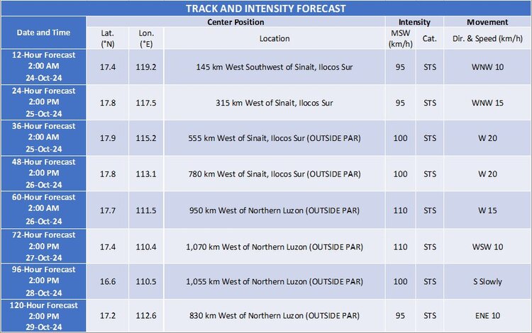
Track and Intensity Outlook
Kristine is forecast to continue moving westward and exit the Philippine Area of Responsibility (PAR) by tomorrow afternoon, October 25. However, Pagasa is closely monitoring its development, as there is a possibility the storm could intensify further and loop back towards the country. Another weather disturbance is being watched east of PAR, which may develop into a tropical depression within the next 24 hours.
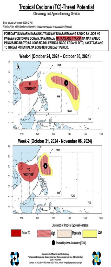
Currently, there is a tropical cyclone being monitored within PAGASA’s monitoring domain. Meanwhile, there is a high chance that another tropical cyclone will develop within the next two weeks. Due to this, the Tropical Cyclone Threat Potential is elevated during the forecast period.
Pagasa will continue to issue regular updates on Severe Tropical Storm Kristine as new data becomes available.