The Philippine Atmospheric, Geophysical and Astronomical Services Administration (PAGASA) has released an advisory on Tropical Storm Nika, which has intensified and is now categorized as a tropical storm. As of 4:00 PM, Nika was located approximately 1,005 kilometers east of southeastern Luzon, moving westward at a speed of 35 km/h. With maximum sustained winds reaching 65 km/h near its center and gusts up to 80 km/h, Nika is expected to bring strong winds and heavy rainfall to multiple areas across Luzon as it continues on a west-northwest trajectory.

Location and Intensity
- Position (4:00 PM): 1,005 km east of southeastern Luzon (14.4°N, 131.0°E)
- Intensity: Maximum sustained winds of 65 km/h, gusts up to 80 km/h, central pressure at 1000 hPa
- Movement: Westward at 35 km/h
- Extent of Winds: Strong to gale-force winds extending 250 km from the center
Tropical Cyclone Wind Signals in Effect
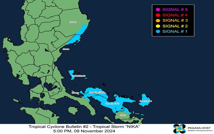
PAGASA has raised Tropical Cyclone Wind Signal No. 1 in several areas, with winds expected to range from 39 to 61 km/h. Residents within these zones should prepare for minimal to minor wind impacts. Affected areas include:
- Luzon: Southeastern portion of Isabela (Dinapigue), northern Aurora (Dilasag, Casiguran, Dinalungan), southeastern mainland Quezon (Calauag, Guinayangan, Tagkawayan), Polillo Islands, Camarines Norte, Camarines Sur, Catanduanes, and northeastern Albay (Malinao, Tiwi, City of Tabaco, Bacacay, Malilipot, Rapu-Rapu).

PAGASA advises that Wind Signal No. 3 could be issued in the coming days if the storm intensifies as forecasted.
Rainfall and Wind Hazards
Heavy rainfall advisories remain in effect, as detailed in PAGASA’s Weather Advisory No. 2. PAGASA warns of possible severe wind impacts in coastal and upland regions directly exposed to storm winds. The current forecast indicates that strong to gale-force gusts will impact areas in Batanes, northern Cagayan including the Babuyan Islands, and Ilocos Norte starting tomorrow, November 10.
Coastal Waters and Sea Conditions
Coastal waters in areas along Nika’s path are expected to be rough to moderate. PAGASA advises mariners of small vessels, particularly those operating in exposed waters, to avoid venturing out to sea due to waves reaching up to 3.0 meters in some areas. Here’s the breakdown:
- Rough Seas (Up to 3.0 m): Northern and eastern seaboards of Catanduanes, seaboard of Kalayaan Islands, and northern seaboard of Camarines Sur.
- Moderate Seas (Up to 2.5 m): Seaboards of Isabela, northern Aurora, and Camarines Norte; northern and eastern seaboards of Polillo Islands and Northern Samar; eastern seaboards of Babuyan Islands, mainland Cagayan, Albay, and Sorsogon.
- Slightly Lower Seas (Up to 2.0 m): Remaining seaboards of Cagayan Valley, seaboard of Ilocos Region; western seaboards of Zambales, Bataan, Lubang Islands, Occidental Mindoro, Calamian Islands, and Palawan; eastern seaboards of Camarines Sur, Eastern Samar, and Dinagat Islands.
Mariners are urged to take precautions, and inexperienced seafarers are advised to avoid sea travel under these conditions.
Track and Intensity Forecast
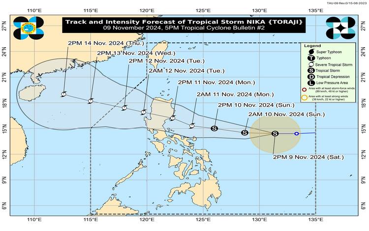
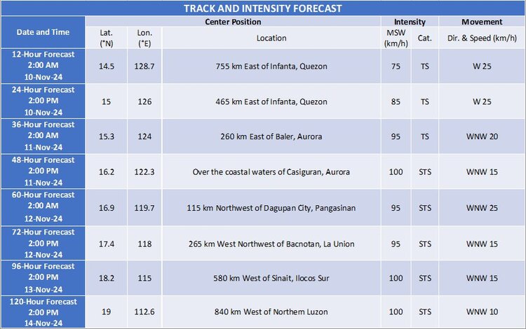
Nika is projected to continue its west-northwestward movement and may make landfall over Isabela or Aurora on Monday, November 11, in the afternoon or evening. PAGASA emphasizes that even areas outside of the predicted landfall region may experience significant weather hazards.
Over the next 48 hours, Nika is expected to strengthen, potentially reaching severe tropical storm status before making landfall. It is forecasted to weaken slightly due to the rugged terrain of Luzon but will likely remain a severe tropical storm as it crosses the mainland.

Public Advisories
Residents in affected areas should prepare for potential hazards associated with strong winds, rainfall, and rough seas. PAGASA advises the public to stay updated on local advisories and alerts from their local disaster management offices and to secure any items that could become hazards in strong winds.
