The Philippine Atmospheric, Geophysical and Astronomical Services Administration (PAGASA) issued its weather forecast this afternoon, warning of possible flash floods and landslides in areas affected by the Intertropical Convergence Zone (ITCZ).
According to PAGASA, the ITCZ is currently influencing weather patterns over Palawan and most of Mindanao. As a result, residents in Mindanao, Central Visayas, Negros Island Region, Western Visayas, Leyte, Southern Leyte, and Palawan can expect cloudy skies with scattered rain showers and thunderstorms. Moderate to at times heavy rainfall may lead to localized flash floods or landslides, particularly in flood-prone and mountainous areas.
Meanwhile, the rest of the country, including Metro Manila, is under the influence of easterlies—warm, moist winds from the Pacific. These areas will experience partly cloudy to cloudy skies with isolated rain showers or thunderstorms, especially during the afternoon or evening. While generally fair, PAGASA cautions that intense thunderstorms could still trigger flash floods or landslides in susceptible regions.
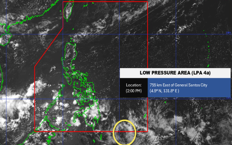
PAGASA is also monitoring a low-pressure area (LPA), designated as LPA 04a, which is currently outside the Philippine Area of Responsibility (PAR). As of this afternoon, it has a low chance of developing into a tropical depression within the next 24 hours.
In terms of marine conditions, light to moderate winds prevail across the country. Northern Luzon will experience winds from the northeast to east with coastal waters ranging from slight to moderate at 1.2 to 2.1 meters in wave height. The rest of the country will have similar wind strength, coming from the east to northeast, with wave heights between 0.6 and 1.5 meters.
Temperature extremes for the past 24 hours recorded a maximum of 34.7°C at 1:00 PM and a minimum of 24.7°C at 6:30 AM. Relative humidity peaked at 88% at 3:00 PM and dipped to a low of 52% earlier in the afternoon.
PAGASA reminds the public to stay updated through official channels and be vigilant against weather hazards, especially in areas with ongoing rains.
Have you been affected by recent thunderstorms or flooding in your area?