The Philippine Atmospheric, Geophysical and Astronomical Services Administration (Pagasa) released its afternoon weather forecast on Friday, August 29, 2025, highlighting the continuing effects of the southwest monsoon across large portions of the country, alongside the trough of a tropical storm located outside the Philippine Area of Responsibility (PAR).
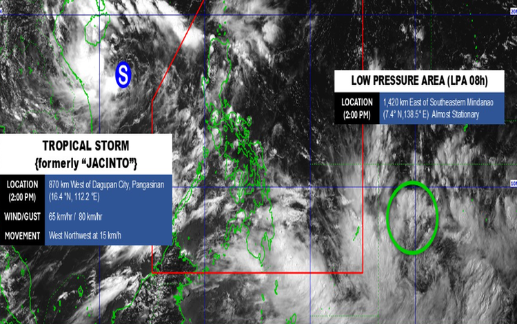
Tropical Storm Jacinto (formerly classified as a tropical depression) was spotted 860 kilometers west of Northern Luzon at coordinates 16.5°N, 112.3°E. It packs maximum sustained winds of 65 kilometers per hour near the center, with gusts reaching up to 80 kilometers per hour. The system is moving west-northwestward at 15 kilometers per hour. Although it remains outside PAR, its trough is influencing weather conditions in the northern and central parts of Luzon.
Forecast Weather Conditions
The Ilocos Region, Batanes, Babuyan Islands, Zambales, and Bataan can expect cloudy skies with scattered rains and thunderstorms due to the trough of Jacinto. Pagasa warned that moderate to at times heavy rains in these areas could result in flash floods or landslides.
Meanwhile, the southwest monsoon continues to dampen MIMAROPA, Visayas, Mindanao, Cavite, and Batangas with cloudy skies and scattered thunderstorms. These areas also face the risk of localized flooding and landslides.
The Cordillera Administrative Region, the rest of Cagayan Valley, and other parts of Central Luzon will see partly cloudy to cloudy skies with isolated rain showers or thunderstorms, also due to the trough of Jacinto. Metro Manila and the rest of Luzon, on the other hand, are forecast to experience similar conditions but under the influence of the southwest monsoon.
Wind and Coastal Conditions
Moderate winds from the southeast to east are expected over Northern Luzon, with coastal waters at 1.2 to 2.5 meters. The Visayas and the rest of Luzon will also experience moderate winds, blowing from the southwest to south, with similar sea conditions. In Mindanao, winds will be light to moderate coming from the south to southwest, producing slight to moderate seas at 0.6 to 1.5 meters.
General Flood Advisories
As of 6:00 p.m., Pagasa issued flood advisories for Central Luzon (GFA #11), CALABARZON (GFA #4), MIMAROPA (GFA #20), Western Visayas (GFA #19), and Eastern Visayas (GFA #23).
The public is urged to stay vigilant, especially in low-lying and mountainous areas, as rains are expected to persist in the coming hours.