The Philippine Atmospheric, Geophysical, and Astronomical Services Administration (PAGASA) issued a weather advisory on February 21, 2025, warning of significant rainfall due to the prevailing shear line affecting various regions in the country.
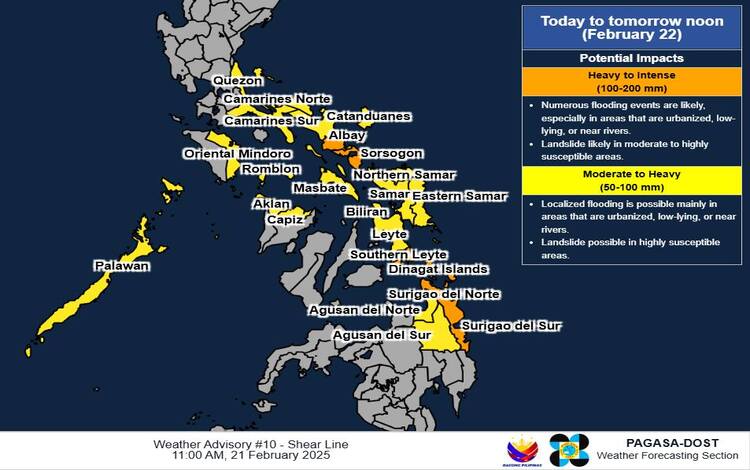
Areas Expected to Experience Heavy to Intense Rainfall (100-200 mm):
- Sorsogon
- Albay
- Southern Leyte
- Dinagat Islands
- Surigao del Norte
- Surigao del Sur
Areas Forecasted for Moderate to Heavy Rainfall (50-100 mm):
- Quezon
- Camarines Norte
- Camarines Sur
- Catanduanes
- Masbate
- Oriental Mindoro
- Romblon
- Palawan
- Aklan
- Capiz
- Northern Samar
- Eastern Samar
- Samar
- Biliran
- Leyte
- Agusan del Norte
- Agusan del Sur
The advisory highlights that rainfall amounts may be higher in mountainous and elevated areas, and the impacts could be exacerbated by previous significant rainfall. Residents in these regions are urged to remain vigilant for possible flash floods and landslides.
PAGASA advises the public and local disaster risk reduction and management offices to implement necessary measures to safeguard life and property. Regional Services Divisions of PAGASA may issue localized Heavy Rainfall Warnings, Rainfall/Thunderstorm Advisories, and other severe weather information pertinent to their areas as needed.

The next weather advisory is scheduled for release at 5:00 PM today unless significant changes in weather conditions occur.
Understanding PAGASA’s Weather Bulletins:
It’s essential to distinguish between a Heavy Rainfall Warning and a Weather Advisory. A Heavy Rainfall Warning offers forecasts for the next three hours and is applicable up to the municipal level. This warning is more precise, utilizing Doppler radar technology to monitor real-time rainfall intensity, making it highly effective for immediate decision-making in flood-prone areas.
Tropical Cyclone Threat Potential Forecast:
As of February 21, 2025, PAGASA reports no active tropical cyclones within its monitoring domain. For the first week of the forecast period, the likelihood of a tropical cyclone-like vortex forming within the monitoring domain is low. However, in the second week, there is a possibility of a tropical cyclone-like vortex developing east of Mindanao and Visayas, though the chance of it intensifying into a tropical cyclone remains low. Consequently, no tropical cyclone threat is anticipated during the forecast period.
Residents are encouraged to stay updated through official PAGASA channels and heed local authorities’ advisories to ensure safety during this period of increased rainfall.