November 10, 2024—The Philippine Atmospheric, Geophysical and Astronomical Services Administration (Pagasa) has reported that severe tropical storm Nika (internationally named Toraji) has intensified significantly and is currently undergoing rapid intensification as it moves closer to the eastern coast of Luzon. With maximum sustained winds of 100 kilometers per hour (kph) and gusts reaching up to 125 kph, Nika is expected to bring strong winds and heavy rainfall to various parts of Luzon in the coming days.

Location and Current Status
As of 4:00 AM today, the center of severe tropical storm Nika was estimated to be around 690 kilometers east of Infanta, Quezon, at coordinates 15.0°N, 128.1°E. Nika is moving west-northwest at a speed of 30 kph, with strong to storm-force winds extending up to 300 kilometers from its center. The storm’s central pressure stands at 985 hPa, a factor contributing to its rapid intensification.
Tropical Cyclone Wind Signals (TCWS)
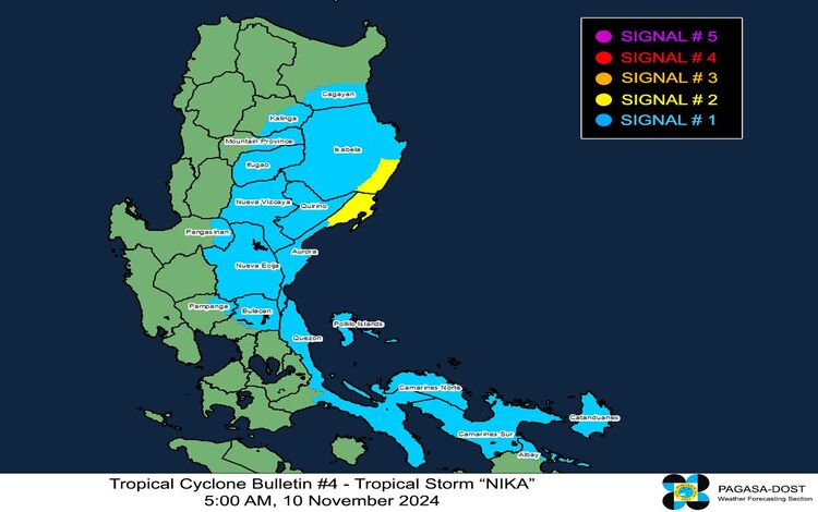
Pagasa has raised Tropical Cyclone Wind Signals (TCWS) across multiple regions in Luzon in anticipation of Nika’s approach.
- TCWS No. 2: Gale-force winds are expected within 24 hours, affecting areas such as the southeastern portion of Isabela (Dinapigue) and the northern portion of Aurora (Dilasag, Casiguran, Dinalungan). Winds ranging from 62 to 88 kph are anticipated, posing a minor to moderate threat to life and property.
- TCWS No. 1: Strong winds with speeds of 39 to 61 kph are expected in a broader range of locations, including parts of Cagayan, Isabela, Quirino, Nueva Vizcaya, Kalinga, Mountain Province, Ifugao, and other areas in Aurora, Nueva Ecija, and Quezon. This signal warns of minimal to minor impacts to life and property, with a lead time of 36 hours.
Wind and Rainfall Hazards
Nika is expected to bring significant hazards to affected areas. Wind signals warn of potential impacts, especially in coastal and mountainous regions where winds may be slightly enhanced due to the cyclone’s intensity. Minor to moderate impacts are possible in areas under Signal No. 2, while minimal to minor impacts are expected under Signal No. 1.
Pagasa issued Weather Advisory No. 4 at 5:00 AM today, highlighting potential heavy rainfall in regions affected by Nika. The storm’s strong winds, especially in exposed areas, could damage susceptible communities.
Coastal and Sea Condition Hazards
Pagasa has issued a Storm Surge Warning No. 2, advising residents of low-lying and coastal areas in Ilocos Norte, Ilocos Sur, La Union, Pangasinan, Cagayan (including the Babuyan Islands), Zambales, Aurora, Quezon (including Polillo Islands), and parts of Bicol to be on alert for possible storm surges. These areas may experience coastal inundation over the next 48 hours.
In addition to storm surge risks, Pagasa warns that rough seas, with waves reaching up to 4.5 meters, may occur along the eastern seaboards of Isabela, northern Aurora, and northern Camarines Norte. Mariners and fishing vessels are advised to avoid sea travel as conditions are unsafe. Small boats and motorbancas are urged to stay in port or seek shelter until conditions improve.
Forecast Track and Intensity
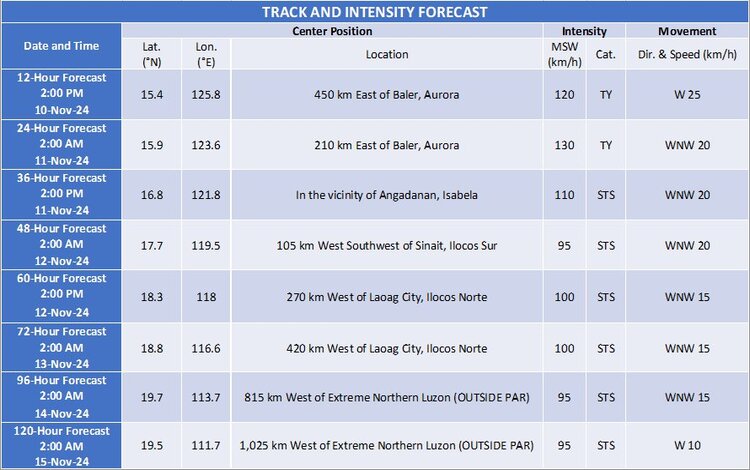
Nika is projected to continue moving west-northwestward over the next 24 hours, with a possible landfall over the provinces of Isabela or Aurora by tomorrow afternoon, November 11. Pagasa stresses that even if the exact point of landfall is uncertain, hazards will affect a wide area outside the storm’s center.
The storm may reach typhoon status later today as it continues to intensify. A temporary weakening is expected once it crosses Luzon due to land interaction, but Nika may regain strength over the West Philippine Sea. It is forecasted to remain a severe tropical storm throughout the remainder of its path.

Precautionary Measures
Pagasa continues to advise the public to stay updated with official weather bulletins and heed the local authorities’ instructions. As Nika intensifies and moves closer, those in affected areas should prepare for potential evacuation and take necessary precautions to secure property and ensure safety, especially in regions under higher wind signal warnings and those prone to flooding and landslides.
