The Philippine Atmospheric, Geophysical and Astronomical Services Administration (PAGASA) has placed a significant portion of the country under a weather watch this weekend, as a Low Pressure Area (LPA) coupled with the Intertropical Convergence Zone (ITCZ) threatens to unleash considerable rainfall across Visayas and Mindanao, extending into Palawan. As of 3:00 PM today, October 26, the LPA was tracked in the vicinity of Matalam, Cotabato, serving as the primary driver for widespread wet weather.
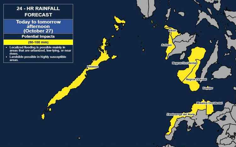
The immediate concern is the risk of heavy rainfall, with 50-100 mm expected to fall from today until tomorrow afternoon, October 27. Areas bracing for this volume include Palawan, Negros Occidental, Negros Oriental, Antique, Aklan, Misamis Occidental, Siquijor, and Zamboanga del Norte. Residents in these provinces must prepare for potential flash floods and landslides, especially given the likelihood of higher rainfall totals in elevated and mountainous terrain. The advisory further cautions that the impacts could be compounded by significant antecedent rainfall, meaning soil saturation levels are already high in many areas.
The weather threat is persistent, with Palawan expected to remain under the 50-100 mm heavy rainfall outlook for a second period, extending from tomorrow afternoon to Tuesday afternoon, October 28. This prolonged exposure demands sustained vigilance from local disaster risk reduction and management offices. These offices, along with the public, are strongly advised to implement all necessary protective measures for life and property.
Beyond the LPA’s direct influence, other weather systems are contributing to the nation’s diverse forecast. The Shear Line is bringing cloudy skies, scattered rains, and thunderstorms to Extreme Northern Luzon, specifically Batanes and the Babuyan Islands, where similar flash flood and landslide risks exist. The Easterlies are also a factor, causing cloudy skies and scattered rains over the Bicol Region, Aurora, and Quezon. The rest of Luzon, including Metro Manila, can expect partly cloudy to cloudy skies with isolated rain showers, though the threat of flash floods during severe thunderstorms remains.
Coastal safety is also a priority. Sea travel conditions will be challenging across the northern and western sections of Northern Luzon, with moderate to strong winds from the Northeast creating moderate to rough seas, featuring wave heights of 1.8 to 3.4 meters. The rest of the country, however, is forecast for lighter winds and generally slight to moderate coastal waters.
PAGASA’s advisory highlights the critical need for localized, real-time information. General Flood Advisories have already been issued for a multitude of regions, from MIMAROPA and Western Visayas to BARMM. The agency stresses the difference between a broad, 24-hour Weather Advisory and the more precise, three-hour, municipal-level Heavy Rainfall Warning. For immediate decision-making, such as class suspensions, the public is directed to refer to the more accurate, Doppler-radar-assisted Heavy Rainfall Warnings issued by their respective PAGASA Regional Services Divisions. The next detailed Weather Advisory is slated for release at 11:00 PM tonight, unless the situation drastically changes.