Tropical Depression Wilma Maintains Strength as It Tracks Southwestward
The Philippine Atmospheric, Geophysical and Astronomical Services Administration (PAGASA) released its 7:00 AM update on Tropical Depression Wilma, reporting that the system continues to maintain its strength while moving southwestward over the Philippine Sea.
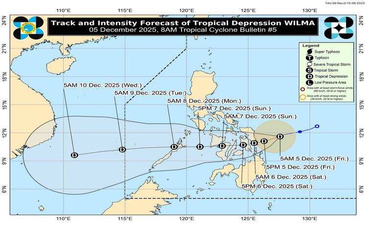
As of early Friday morning, Wilma’s center was estimated at 235 km east of Borongan City, Eastern Samar (11.6°N, 127.6°E). The tropical depression is packing maximum sustained winds of 45 km/h, gusts of up to 55 km/h, and a central pressure of 1004 hPa. It is moving southwestward at 15 km/h, with strong winds extending up to 220 km from its center.
Wind Signals Raised
Tropical Cyclone Wind Signal No. 1 remains hoisted over several areas in Luzon, Visayas, and Mindanao due to the threat of strong winds within the next 36 hours. PAGASA warns that these winds may cause minimal to minor damage, especially in coastal and elevated areas.
Signal No. 1 Areas Include:
Luzon:
• Southern portion of mainland Masbate, including Cataingan, Esperanza, Placer, Palanas, Uson, and nearby towns.
Visayas:
• Northern Samar, Eastern Samar, Samar, Biliran
• Leyte, Southern Leyte, Cebu (including Bantayan and Camotes Islands)
• Bohol, Guimaras
• Portions of Negros Occidental and Negros Oriental
• Eastern parts of Iloilo and Capiz
• Siquijor
Mindanao:
• Surigao del Norte (including Siargao and Bucas Grande)
• Dinagat Islands
• Parts of Surigao del Sur and Agusan del Norte
• Camiguin

Rainfall, Winds, and Other Hazards
PAGASA reiterates that heavy rainfall due to Wilma and the shear line may affect regions in the Visayas and parts of Mindanao. Residents are advised to monitor PAGASA’s Weather Advisory No. 7 for detailed rainfall forecasts.
While Wilma’s winds pose minimal to minor threats under Signal No. 1, the Northeast Monsoon (Amihan) is also enhancing strong to gale-force gusts over most of Luzon and Visayas today and in the following days. By December 7, these strong winds may also affect Zamboanga Peninsula and Misamis Occidental.
Coastal Waters Expected to Be Dangerous
A Gale Warning is in effect over the northern and western seaboards of Northern Luzon and the eastern seaboards of both Luzon and Visayas. Sea conditions will range from rough to very rough, with waves reaching up to 5.5 meters in some areas.
PAGASA strongly advises:
- All vessels are to remain in port or seek safe harbor
- Small boats and motorbancas to avoid sea travel entirely
- Mariners to take extreme caution as winds and waves may worsen in open waters
Track and Intensity Forecast
Wilma is projected to continue moving west-southwestward today before turning generally westward through the weekend. PAGASA forecasts that the system may either make landfall or pass close to Eastern Visayas or Dinagat Islands between Friday evening and early Saturday morning.
From there, Wilma is expected to cross the Visayas region and emerge over the Sulu Sea by Sunday (December 7). By Monday morning (December 8), the cyclone may pass over or near northern Palawan.
Although slight intensification is possible before landfall, Wilma is expected to remain a tropical depression while over land. Strengthening may occur once it moves into the West Philippine Sea.
PAGASA’s Reminder to the Public
PAGASA emphasizes that hazardous conditions—especially heavy rainfall and strong winds—may occur outside the predicted track and cone of uncertainty. With Wilma nearing the country’s eastern seaboard, local governments and disaster response units are urged to prepare for possible flooding, disruptions in sea travel, and gusty conditions enhanced by the Amihan.
The public is encouraged to stay updated with official advisories and follow local safety protocols as the weather system continues its approach.