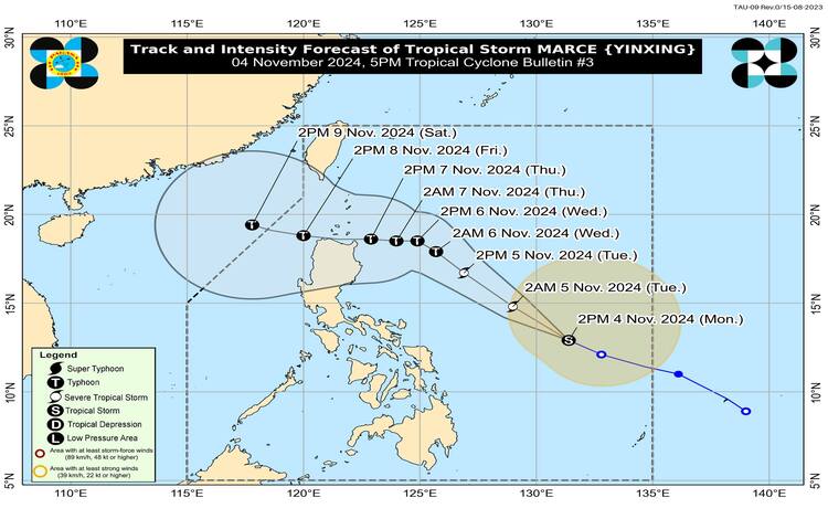
Tropical Storm MARCE has shown significant intensification as it progresses over the Philippine Sea, approximately 740 kilometers east of Virac, Catanduanes, as of the latest update at 4:00 PM today. The storm is currently situated at coordinates 13.1°N latitude and 131.0°E longitude, with maximum sustained winds reaching 85 kilometers per hour near the center. Gusts have been recorded at up to 105 kilometers per hour, and the central pressure of the storm is measured at 994 hPa.

Current Movement and Wind Signals
The storm is moving west-northwestward at a pace of 30 kilometers per hour. As of now, there are no tropical cyclone wind signals in effect. However, this could change as MARCE continues its trajectory. The extent of tropical cyclone winds is considerable, with strong to gale-force winds extending outward up to 580 kilometers from the storm’s center.
Heavy Rainfall and Potential Hazards
As MARCE advances northwestward within the Philippine Area of Responsibility (PAR), it is expected to enhance the northeasterly wind flow in the region. This weather pattern is likely to lead to significant rainfall over Extreme Northern Luzon and the eastern sections of Luzon starting today or by Tuesday. The Philippine Atmospheric, Geophysical, and Astronomical Services Administration (PAGASA) may issue a weather advisory as the storm approaches Northern Luzon.
Severe winds are anticipated, with the possibility of hoisting Tropical Cyclone Wind Signal No. 1 over portions of Cagayan tonight or tomorrow morning. The highest wind signal that may be raised during MARCE’s passage is Wind Signal No. 4. The following areas are expected to experience strong to gale-force gusts due to the northeasterly wind flow:
- Today (November 4): Batanes, Cagayan (including the Babuyan Islands), Isabela, Ilocos Norte, Aurora, and the northern portion of Quezon.
- Tomorrow (November 5): The same areas as above, with the addition of Ilocos Sur, and parts of Quezon and Camarines Norte.
- Wednesday (November 6): Ilocos Region, Quezon, Camarines Norte, Camarines Sur, and Catanduanes.
Coastal Conditions and Gale Warnings
The 24-hour sea condition outlook indicates rough seas along various coastal waters. Mariners should exercise caution, particularly those navigating small seacrafts and motorbancas, which are advised not to venture out to sea under the current conditions. The forecast for sea conditions is as follows:
- Rough seas (up to 3.5 m): The seaboard of Batanes.
- Rough seas (up to 3.0 m): Babuyan Islands, Ilocos Norte, Ilocos Sur, Isabela, northern Aurora, and the eastern seaboard of mainland Cagayan.
- Moderate seas (up to 2.5 m): Remaining seaboards of mainland Cagayan and Aurora, as well as the northern and eastern seaboards of Polillo Islands.
A Gale Warning is expected to be issued over the seaboard of Northern Luzon tomorrow.
Future Track and Intensity Outlook
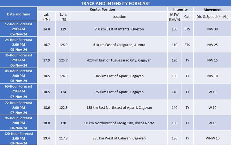
Forecast models suggest that MARCE will continue to move generally west-northwest until tomorrow (November 5) before turning westward at a slower pace over the Philippine Sea, east of Extreme Northern Luzon. Projections indicate that the storm may make landfall near the Babuyan Islands or mainland northern Cagayan on Thursday evening (November 7) or early Friday morning (November 8). There remains uncertainty regarding the strength of the high-pressure area north of MARCE, which could alter the storm’s landfall point.

As it stands, MARCE is expected to gradually intensify and may reach the severe tropical storm category tonight or tomorrow morning. There is a likelihood of it evolving into a typhoon by tomorrow evening or early Wednesday morning, with rapid intensification anticipated. Residents in affected areas are urged to stay informed and prepared as the situation develops.
