The Philippine Atmospheric, Geophysical and Astronomical Services Administration (PAGASA) announced that Tropical Storm Nakri has entered the Philippine Area of Responsibility (PAR) and has been given the local name “Quedan.” The weather system is the 17th tropical cyclone to enter the country this year.
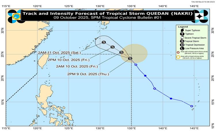
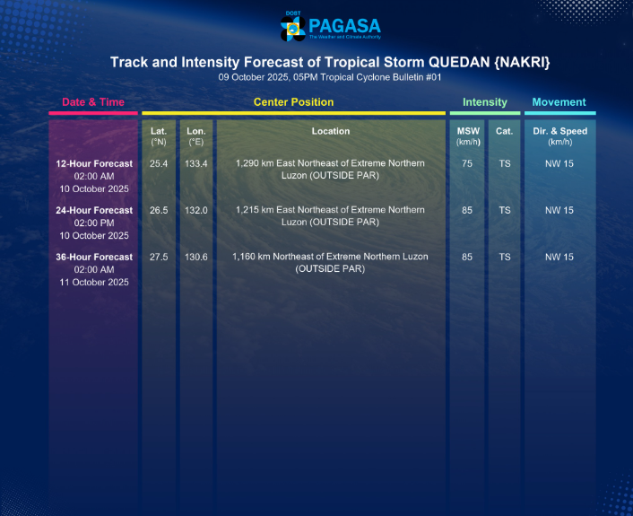
As of 4:00 PM on Thursday, October 9, the center of Quedan was estimated at 1,370 kilometers east-northeast of Extreme Northern Luzon (24.3°N, 134.6°E). The tropical storm is currently packing maximum sustained winds of 75 kilometers per hour (km/h) near its center, with gustiness reaching up to 90 km/h and a central pressure of 998 hPa. It is moving north-northwestward at 30 km/h, with strong to gale-force winds extending up to 360 kilometers from the center.
No Tropical Cyclone Wind Signal in Effect
PAGASA confirmed that no Tropical Cyclone Wind Signals (TCWS) have been raised across the country since Quedan remains too far to directly impact any Philippine landmass. Despite its presence inside PAR, the storm is less likely to affect the country’s weather conditions.
Other Weather Systems Bringing Winds and Rain
Although Quedan is not expected to cause direct rainfall, other prevailing weather systems—including the southwesterlies, a low-pressure area (LPA 10C), and the northeasterly windflow—will bring strong to gale-force gusts over several areas.
Today, affected regions include Batanes, Babuyan Islands, Ilocos Norte, Palawan, Negros Island Region, Central Visayas, Leyte, Southern Leyte, Caraga, Northern Mindanao, Zamboanga Peninsula, BARMM, SOCCSKSARGEN, Davao Occidental, Davao del Sur, and Davao Oriental.
By Friday, October 10, and Saturday, October 11, these winds are forecast to persist across Ilocos Norte, Palawan, Romblon, Masbate, Visayas provinces, and parts of Mindanao. Residents, especially those in coastal and upland areas, are advised to take extra precautions against strong winds and rough seas.
Sea and Flood Conditions
PAGASA said Quedan is unlikely to affect sea conditions within the country’s coastal waters for the next 24 hours. However, general flood advisories have been issued as of 6:00 PM, October 9, for several regions including CALABARZON (GFA#1), MIMAROPA (GFA#6), Bicol Region (GFA#5), Western Visayas (GFA#5), Central Visayas (GFA#5), Eastern Visayas (GFA#5), Northern Mindanao (GFA#6), Davao Region (GFA#8), SOCCSKSARGEN (GFA#8), CARAGA (GFA#5), and BARMM (GFA#8).
Track and Intensity Outlook
Based on PAGASA’s forecast, Quedan is expected to continue moving northwestward and may exit the PAR tonight or by early Friday morning, October 10. The tropical storm is also projected to further intensify as it moves closer to the Ryukyu Islands in Japan.