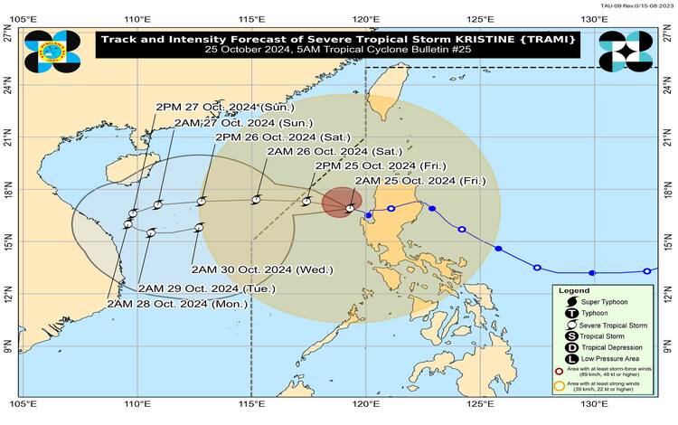
As of October 25, 2024, the Philippine Atmospheric, Geophysical, and Astronomical Services Administration (PAGASA) has provided the latest updates on Severe Tropical Storm “Kristine” (international name: Trami). According to PAGASA, the storm has maintained its strength as it continues accelerating west-northwestward over the sea west of Northern Luzon.
Current Location and Intensity
As of 4:00 AM today, the center of Severe Tropical Storm Kristine was located approximately 125 kilometers west-northwest of Bacnotan, La Union, at coordinates 17.1°N, 119.3°E. The storm packs maximum sustained winds of 95 kilometers per hour near the center, with gusts reaching up to 115 kilometers per hour. Its central pressure is recorded at 985 hPa.
Kristine is currently moving west-northwestward at 25 kilometers per hour, and its strong storm-force winds extend outward up to 730 kilometers from the center.
Tropical Cyclone Wind Signals (TCWS) in Effect
PAGASA has raised Tropical Cyclone Wind Signals (TCWS) over multiple areas in Luzon due to the gale force and strong winds associated with Kristine:
- TCWS No. 2 (Gale-force Winds): Cagayan, including Babuyan Islands, Isabela, Quirino, Nueva Vizcaya, Apayao, Kalinga, Abra, Ifugao, Mountain Province, Benguet, Ilocos Norte, Ilocos Sur, La Union, Pangasinan, Aurora, Nueva Ecija, Tarlac, Zambales, Bataan, Pampanga, Bulacan, Metro Manila, northern portions of Cavite, Rizal, and mainland Quezon. Expected wind speeds in these areas range from 62 to 88 kilometers per hour (Beaufort 8 to 9), posing minor to moderate threats to life and property.
- TCWS No. 1 (Strong Winds): Batanes, parts of Rizal, Cavite, Batangas, Laguna, Quezon, Occidental Mindoro, Oriental Mindoro, Marinduque, Romblon, Palawan, Camarines Norte, Camarines Sur, Catanduanes, Albay, parts of Sorsogon, Masbate, Aklan, Capiz, Antique, Iloilo, and several islands. Wind speeds in these regions range from 39 to 61 kilometers per hour (Beaufort 6 to 7), with minimal to minor threats to life and property.
Heavy Rainfall and Severe Winds
PAGASA has advised the public to refer to Weather Advisory No. 26, issued at 5:00 AM, for details on heavy rainfall. The storm is expected to bring widespread rains, which could lead to localized flooding and landslides, especially in mountainous and low-lying areas.
Winds are expected to strengthen further in areas under Wind Signal No. 2, with coastal and upland areas at risk of experiencing stronger gusts. Meanwhile, minimal to moderate impacts from gale-force winds are expected within these localities. The southwesterly wind flow and Kristine’s circulation are also expected to enhance winds over MIMAROPA, the Bicol Region, Visayas, and parts of Mindanao.
Coastal Inundation and Sea Conditions
A storm surge warning is in effect for coastal areas in Ilocos Sur, La Union, Pangasinan, and Zambales, with peak storm surge heights of 1.0 to 2.0 meters above normal tide levels. Coastal communities are advised to take precautions as waves could cause flooding in low-lying areas.
A gale warning has also been raised for the seaboard of Luzon and the western seaboard of the Visayas. Sea conditions over the affected areas will be rough to very rough, with wave heights reaching up to 7.0 meters in some areas. Mariners are advised to remain in port or seek shelter due to hazardous sea conditions.
Track and Intensity Outlook
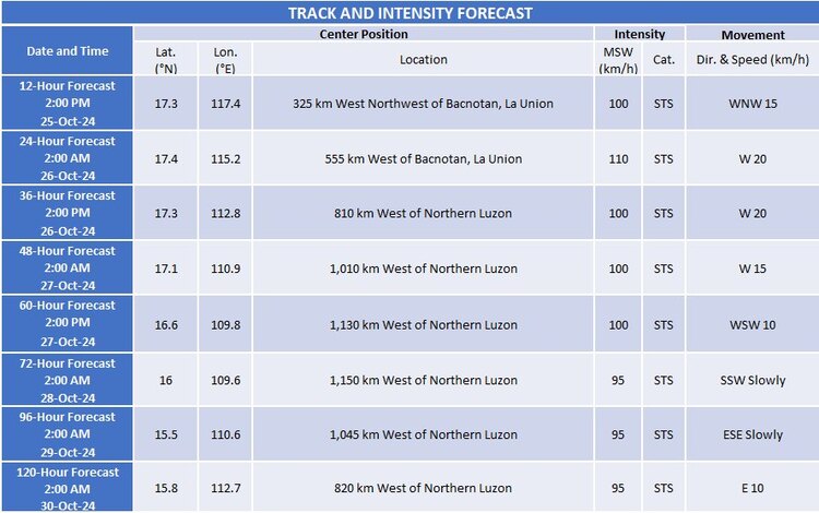
Kristine is forecast to move west-northwestward and is expected to exit the Philippine Area of Responsibility (PAR) by this afternoon. However, PAGASA has indicated a possible development wherein Kristine could loop back over the West Philippine Sea by Sunday or Monday and move eastward, potentially re-entering the PAR region. This scenario is dependent on the behavior of another tropical cyclone east of the Philippines.
Kristine is projected to undergo a brief period of intensification as it travels over the West Philippine Sea. While it is expected to remain a severe tropical storm in the next five days, PAGASA has not ruled out the possibility of Kristine intensifying into a typhoon during this period.
Preparedness Measures
Local authorities and the public are advised to stay informed by monitoring updates from PAGASA and other government agencies. Preparedness measures, especially in areas under TCWS No. 2 and coastal regions, are crucial to mitigate the impact of strong winds, heavy rainfall, and potential storm surges.