The Philippine Atmospheric, Geophysical, and Astronomical Services Administration (PAGASA) has provided the latest details on Typhoon “Leon” (international name: Kong-Rey) as it moves slowly over the Philippine Sea. The storm is expected to intensify, potentially affecting various regions in the Philippines with strong winds, heavy rainfall, and turbulent coastal waters.
Current Location and Strength
As of 4:00 AM, the center of Typhoon Leon was located approximately 840 kilometers east of Central Luzon, specifically at 16.6°N latitude and 130.0°E longitude. It currently has maximum sustained winds of 85 km/h near its center, gusts reaching 105 km/h, and a central pressure of 990 hPa. Leon is moving westward at 10 km/h, with strong to gale-force winds extending outward up to 520 kilometers from its center.
Tropical Cyclone Wind Signal No. 1
Tropical Cyclone Wind Signal No. 1 has been raised over several parts of Luzon, warning of strong winds and minimal to minor threats to life and property within 36 hours. Areas under this signal include:
- The eastern portion of mainland Cagayan: Santa Ana, Lal-Lo, Gattaran, Baggao, Santa Teresita, Gonzaga, and Peñablanca.
- Eastern portion of Isabela: Maconacon, Divilacan, Ilagan City, San Pablo, Cabagan, Tumauini, Palanan, San Mariano, and Dinapigue.
- The northeastern portion of Catanduanes: Pandan, Bagamanoc, Panganiban, and Viga.
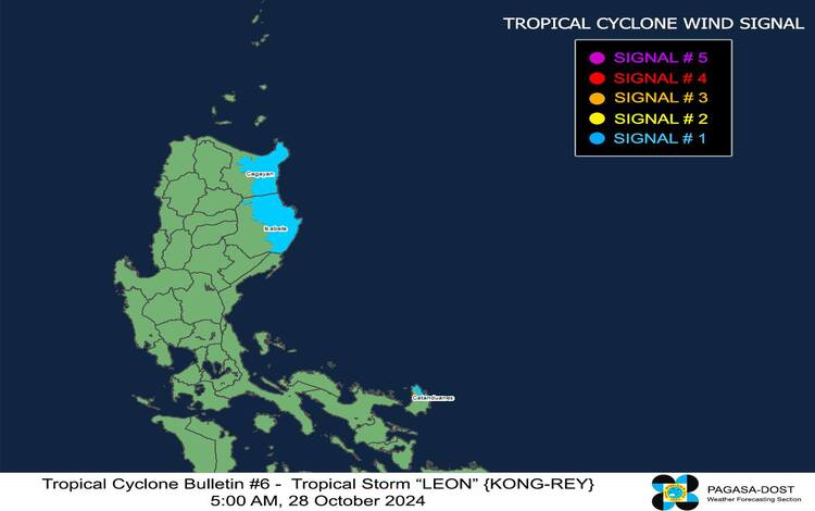
Leon’s highest possible wind signal could be raised to Signal No. 2 or 3, depending on its proximity to the northern regions as it moves north-northwestward.
Rainfall and Wind Impacts
Leon’s outer rainbands may bring heavy rains over extreme Northern Luzon, and its trough could affect parts of the Visayas, Mindanao, and the western sections of Southern Luzon. PAGASA may issue weather advisories as the storm progresses. Within areas under Signal No. 1, residents should expect winds that could cause minimal impacts, especially in coastal and elevated regions. Enhanced winds may also extend to nearby regions, with gusty conditions over the following areas:
- Today (October 28): Batangas, most of MIMAROPA, Bicol Region, Visayas, Northern Mindanao, and Caraga.
- Tomorrow (October 29): Aurora, Metro Manila, CALABARZON, MIMAROPA, Bicol Region, Visayas, Dinagat Islands, Surigao del Norte, and Camiguin.
- Wednesday (October 30): Aurora, Metro Manila, CALABARZON, MIMAROPA, Bicol Region, Western Visayas, Negros Occidental, and Northern Samar.
Coastal Waters and Sea Conditions
Leon is expected to create hazardous sea conditions, particularly around Northern Luzon’s coastal waters. Forecasted sea conditions include:
- Very rough seas (up to 4.5 meters) around the Batanes seaboard, make sea travel risky for all types of vessels. Mariners are urged to remain in port or seek shelter.
- Rough seas (up to 4.0 meters) around Babuyan Islands, Isabela’s seaboard, and eastern mainland Cagayan, and up to 3.0 meters along the northern seaboard of Aurora and the coasts of Camarines Norte and Catanduanes.
- Moderate seas (up to 2.5 meters) near Ilocos Norte and remaining seaboards in Aurora and Northern Samar, advising smaller boats to proceed cautiously.
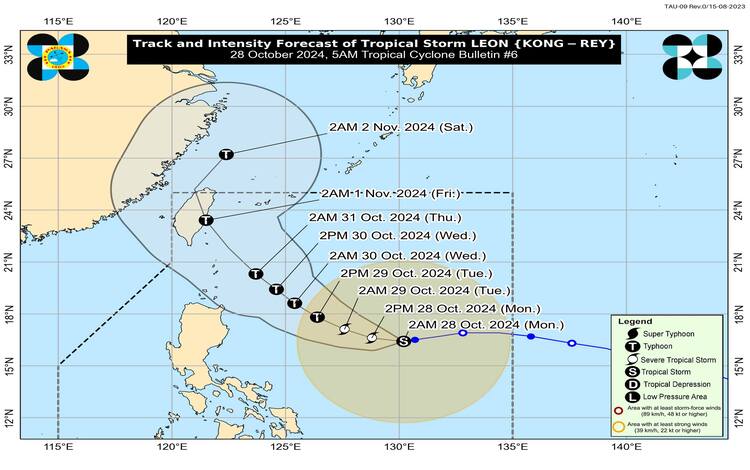
Track and Intensity Outlook
Leon is forecast to continue moving westward over the next 12 hours, then shift west-northwest by tomorrow, October 29. It is expected to pass close to Batanes on Wednesday, October 30, or Thursday, October 31. The typhoon is likely to intensify to a severe tropical storm category later today and could undergo rapid intensification.
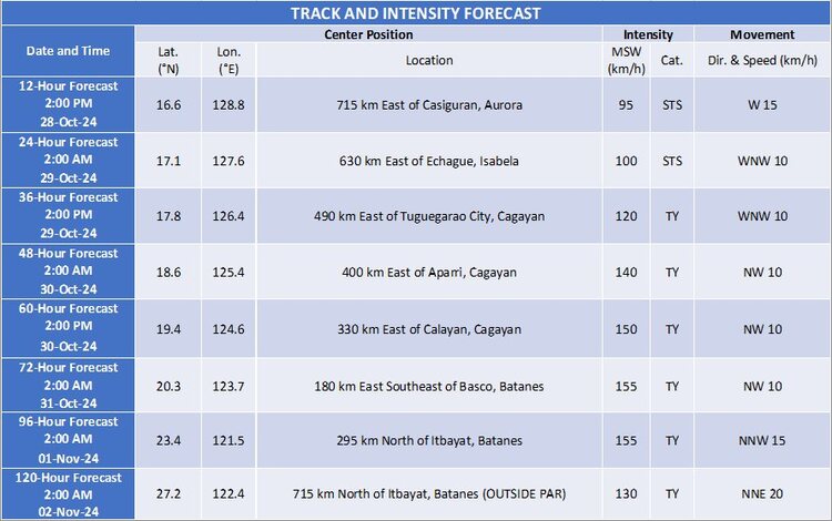
By November 1, Leon is anticipated to make landfall over Taiwan and then veer north-northeast into the East China Sea. Residents and mariners in affected areas are advised to remain vigilant, heed local advisories, and prepare for worsening weather conditions as Typhoon Leon progresses.