MANILA, Philippines – July 23, 2025 — The Philippine Atmospheric, Geophysical and Astronomical Services Administration (PAGASA) has released a comprehensive weather advisory highlighting the significant impacts of Tropical Cyclones “Emong” and “Dante,” as well as the intensified Southwest Monsoon (Habagat), currently affecting wide portions of Luzon and the Visayas.
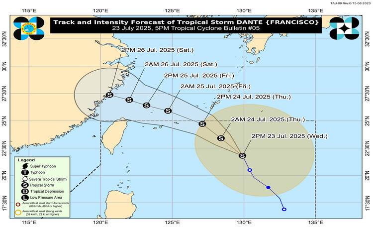
Tropical Cyclone “Dante” Maintains Strength, Nearing Exit from PAR
As of 4:00 PM today, Tropical Storm “Dante” remains strong as it moves north-northwestward at 25 km/h. Located 835 km east northeast of Extreme Northern Luzon (22.2°N, 129.8°E), Dante carries maximum sustained winds of 65 km/h and gusts of up to 80 km/h. Strong to gale-force winds extend up to 350 km from its center. PAGASA forecasts the storm to exit the Philippine Area of Responsibility (PAR) by tomorrow afternoon or evening, heading toward the Ryukyu Islands and the East China Sea.
Despite its distance, Dante continues to enhance the Southwest Monsoon, increasing rainfall and severe weather risks throughout several regions.
Heavy Rainfall Forecast from July 23 to 26
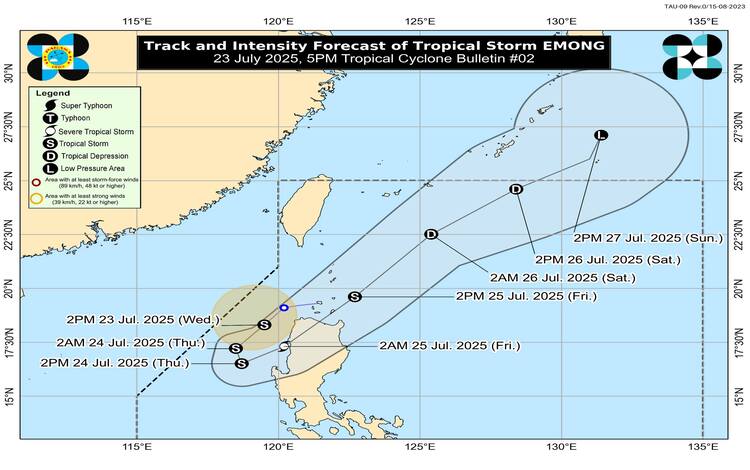
Due to Tropical Cyclones Emong and Dante:
July 23 to 24 (Today to Tomorrow Afternoon):
- 50-100 mm: Cagayan, Abra, Kalinga, Apayao, and Isabela
- 100-200 mm: Ilocos Norte, Ilocos Sur, La Union, Benguet, and Pangasinan
July 24 to 25 (Tomorrow Afternoon to Friday Afternoon):
- 50-100 mm: Apayao, Kalinga, Mountain Province, and Ifugao
- 100-200 mm: Ilocos Norte, Ilocos Sur, Abra, and Benguet
- >200 mm: Pangasinan and La Union
July 25 to 26 (Friday Afternoon to Saturday Afternoon):
- 50-100 mm: Ilocos Norte, Ilocos Sur, Abra, and Benguet
- 100-200 mm: La Union and Pangasinan
Due to Enhanced Southwest Monsoon:
July 23 to 24:
- 50-100 mm: Nueva Vizcaya, Ifugao, Mountain Province, Nueva Ecija, Quezon, Oriental Mindoro, Palawan, Marinduque, Romblon, and Antique
- 100-200 mm: Metro Manila, Tarlac, Pampanga, Bulacan, Cavite, Batangas, Laguna, and Rizal
- >200 mm: Zambales, Bataan, and Occidental Mindoro
July 24 to 25:
- 50-100 mm: Nueva Vizcaya, Nueva Ecija, Bulacan, Metro Manila, Laguna, Rizal, Oriental Mindoro, Palawan, Marinduque, and Romblon
- 100-200 mm: Bataan, Tarlac, Pampanga, Cavite, Batangas, and Occidental Mindoro
- >200 mm: Zambales
July 25 to 26:
- 50-100 mm: Bataan, Occidental Mindoro, and Palawan
- 100-200 mm: Zambales
Severe Winds and Gale Warnings
Strong to gale-force winds are expected across Luzon, Visayas, and portions of Mindanao, especially in coastal and upland areas. Wind conditions are expected to persist until Friday, July 25, affecting areas such as Metro Manila, Central Luzon, CALABARZON, Bicol Region, MIMAROPA, and other regions.
Gale warnings remain in effect, particularly over the western seaboard of Northern Luzon, with sea conditions reaching up to 6.0 meters in Pangasinan and 4.5 meters in Zambales and Bataan. Sea travel is deemed dangerous for all types of vessels in these areas. Mariners are advised to remain in port or seek safe harbor.
Flood Advisories and Risk Warnings
General Flood Advisories have been issued across Regions I to VI, CAR, and NCR. With already saturated soils due to previous rains, PAGASA warns that even moderate rainfall may result in flash floods and landslides, especially in mountainous and low-lying areas.
Residents, local government units, and disaster response teams are urged to take all necessary precautions to safeguard life and property. Local PAGASA offices may issue localized heavy rainfall warnings and thunderstorm advisories as conditions develop.