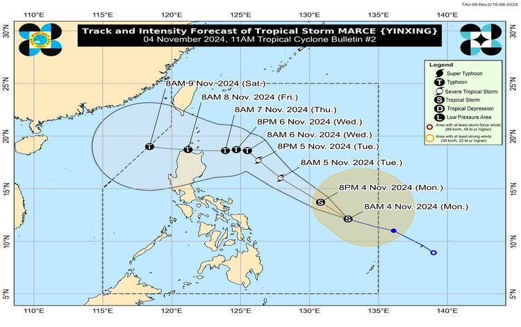
Tropical Storm “Marce” (international name Yinxing) has slightly intensified as it continues to move west-northwestward across the Philippine Sea, according to PAGASA’s latest 11 a.m. bulletin. The storm is currently located approximately 775 kilometers east of Borongan City, Eastern Samar. Marce’s center was pinpointed at coordinates 12.4°N, 132.5°E as of 10 a.m. today.

Storm Intensity and Movement
Tropical Storm Marce has recorded maximum sustained winds of 75 km/h near its center, with gustiness reaching up to 90 km/h. The storm is moving at a steady pace of 35 km/h towards the west-northwest and carries a central pressure of 998 hPa. Its current strength may still increase, with PAGASA indicating that Marce could develop into a severe tropical storm by tomorrow, November 5.
Tropical Cyclone Wind Signals (TCWS)
As of this update, no Tropical Cyclone Wind Signals (TCWS) have been raised in any region. However, PAGASA has cautioned that TCWS No. 1 may be issued over parts of Cagayan province by tomorrow as Marce approaches closer to land. The agency has further warned that the maximum TCWS level could reach Signal No. 4 depending on the storm’s intensity and trajectory.
Weather Effects on Land Areas
Heavy Rainfall Forecast
Marce’s movement within the Philippine Area of Responsibility (PAR) is expected to intensify the northeasterly wind flow, which will likely affect northern and eastern parts of Luzon. This effect, along with Marce’s outer rain bands, may cause rainfall over Extreme Northern Luzon and the eastern sections of Luzon beginning today or Tuesday. PAGASA has advised that a Weather Advisory may be released in the coming days as Marce nears Northern Luzon, bringing moderate to heavy rains in these regions.
Strong to Gale-Force Winds
Alongside the tropical storm’s influence, northeasterly wind flow will create strong to gale-force winds over exposed coastal and upland areas. This will affect regions including Batanes, Cagayan, and Babuyan Islands, as well as the northern provinces of Luzon. Specific wind forecasts for the coming days are as follows:
- Today (November 4): Batanes, Cagayan including Babuyan Islands, Isabela, Ilocos Norte, Aurora, and the northern portion of Quezon.
- Tomorrow (November 5): Additional areas will include Ilocos Sur and Camarines Norte.
- Tuesday (November 6): Further expansion to Camarines Sur, Catanduanes, and the Ilocos Region.
Coastal Hazards and Sea Conditions
PAGASA has advised mariners and small watercraft to take extreme caution due to rough seas in several coastal areas. In particular, waves of up to 3.5 meters are expected along the seaboards of Batanes, while seas around the Babuyan Islands, Ilocos Norte, and Ilocos Sur may experience waves of up to 3.0 meters. Additionally, moderate sea conditions with wave heights up to 2.5 meters are anticipated around mainland Cagayan, Isabela, Aurora, and northern Quezon, among others. Mariners are advised to avoid venturing out to sea in these conditions unless necessary, and a Gale Warning may be issued for Northern Luzon’s coastal waters as early as tomorrow evening or Wednesday.
Track and Intensity Forecast
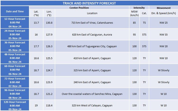
Marce is expected to continue its west-northwest trajectory until November 5, after which it is predicted to slow down and veer westward. Current projections indicate a possible landfall over Babuyan Islands or mainland northern Cagayan on Thursday evening (November 7) or early Friday morning (November 8). The storm’s intensity may increase substantially, potentially reaching typhoon status by Wednesday morning.

Uncertainty remains regarding the influence of a high-pressure area north of Marce, which could alter the storm’s path and affect its landfall location. Residents in Northern Luzon are urged to remain vigilant and monitor updates from PAGASA, as Tropical Storm Marce continues to pose significant weather hazards.
