MANILA, Philippines — July 22, 2025 — The low pressure area (LPA) previously monitored east of Aurora has developed into Tropical Depression “DANTE”, according to the Philippine Atmospheric, Geophysical and Astronomical Services Administration (PAGASA). As of 4:00 PM today, the center of Tropical Depression DANTE was located approximately 1,115 km east northeast of Central Luzon, or 1,130 km east of Northern Luzon, with coordinates at 18.3°N, 132.4°E.
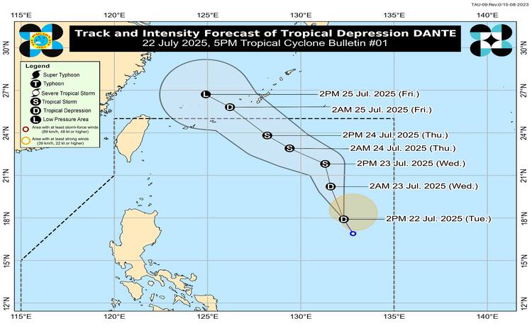
DANTE is currently packing maximum sustained winds of 45 km/h near the center, gusting up to 55 km/h, with a central pressure of 1000 hPa. It is moving north-northwestward at a speed of 20 km/h. While no Tropical Cyclone Wind Signals (TCWS) have been hoisted so far, DANTE is already affecting the country through its enhancement of the Southwest Monsoon (Habagat).
Heavy Rainfall and Flooding Concerns
PAGASA has warned of widespread heavy rainfall due to the interaction of DANTE with the southwest monsoon and other weather systems. Areas expected to experience more than 200 mm of rain from today until July 23 include Zambales, Bataan, Metro Manila, Cavite, Batangas, and Occidental Mindoro. Meanwhile, provinces such as Pangasinan, Benguet, Tarlac, Pampanga, Bulacan, Laguna, and Rizal may see 100 to 200 mm of rainfall.
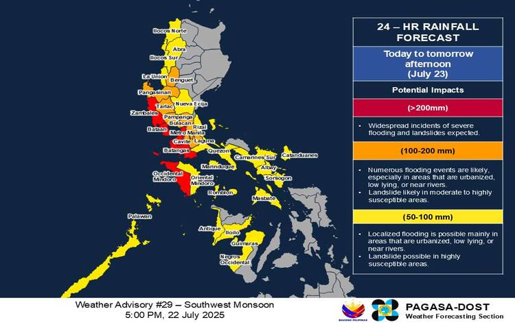
From July 23 to July 24, rainfall over Pangasinan, Zambales, and Bataan may again exceed 200 mm, while Metro Manila, Cavite, Batangas, Laguna, and other neighboring provinces will likely receive 100–200 mm. Additional rainfall from July 24 to July 25 is expected across Ilocos Region, Central Luzon, and parts of Southern Luzon, posing risks of flash floods and landslides, especially in elevated terrain.
Strong Winds and Sea Conditions
Though DANTE remains a weak tropical depression, its interaction with the monsoon has resulted in strong to gale-force winds across Luzon, Visayas, and portions of Mindanao. On July 22, strong winds are impacting areas such as Zambales, Bataan, Metro Manila, CALABARZON, MIMAROPA, Visayas, and Dinagat Islands. These gusty conditions will likely persist through July 24.
Mariners and coastal communities are also cautioned against rough sea conditions. Waves may reach up to 3.0 meters along the western seaboards of Zambales, Bataan, Lubang Island, and Palawan. Moderate to rough seas (up to 2.5 meters) are expected in coastal waters surrounding the Ilocos Region, Babuyan Islands, and parts of Southern Luzon and the Visayas. Small sea vessels and motorbancas are advised not to venture out to sea, especially under these hazardous conditions.
Forecast Track and Development
According to PAGASA, Tropical Depression DANTE will continue tracking north to northwestward over the Philippine Sea until July 23, after which it is forecast to veer toward the Ryukyu Islands and the East China Sea. Based on current projections, DANTE may exit the Philippine Area of Responsibility (PAR) by Thursday, July 24 or Friday, July 25.
There is a high chance that DANTE could intensify into a tropical storm within the next 24 hours. While it is unlikely to escalate into a severe tropical storm, PAGASA has not ruled out this possibility entirely.
Flood Advisories and Public Warnings
PAGASA has issued multiple General Flood Advisories (GFA) for areas across NCR, Central and Northern Luzon, Bicol Region, MIMAROPA, and parts of the Visayas. Rainfall in mountain regions may be intensified by topography, potentially exacerbating existing conditions from earlier rains.
The public is strongly advised to stay alert for localized heavy rainfall warnings and thunderstorm advisories, and to monitor updates from PAGASA’s Regional Services Divisions. Disaster risk reduction and management offices are urged to implement precautionary measures to safeguard lives and property.