The Philippine Atmospheric, Geophysical and Astronomical Services Administration (PAGASA) released its 5 p.m. forecast today, May 24, 2025, highlighting widespread weather disturbances caused by the Intertropical Convergence Zone (ITCZ) and prevailing easterlies.
According to PAGASA, the ITCZ is currently affecting Visayas, Mindanao, Palawan, and parts of Southern Luzon, including Sorsogon, Albay, and Masbate. These areas are expected to experience cloudy skies with scattered rain showers and thunderstorms throughout the afternoon and evening. Residents are warned of possible flash floods and landslides, especially in areas with sustained or heavy rainfall.
In contrast, Metro Manila and the rest of Luzon are under the influence of easterlies. These areas can expect partly cloudy to cloudy skies with isolated rain showers or thunderstorms. Although generally fair, PAGASA warned that severe thunderstorms could still lead to localized flooding or landslides, particularly in low-lying and mountainous areas.
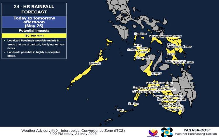
Rainfall Outlook and Advisories
PAGASA forecasts 50–100 mm of rainfall from today until tomorrow afternoon (May 25) across Palawan, Negros Oriental, Siquijor, Zamboanga Peninsula, Misamis Occidental, Lanao provinces, Maguindanao, Basilan, Sulu, South Cotabato, Sultan Kudarat, and Sarangani. From tomorrow afternoon to Monday afternoon (May 26), heavy rains are likely to persist in Palawan. Rainfall totals may be higher in elevated areas due to orographic effects and pre-existing soil saturation.
Flood Advisories and Preparedness
As of 6:00 PM today, PAGASA has issued General Flood Advisories (GFA) for 11 regions, including MIMAROPA (GFA#4), Western Visayas (GFA#1), Central Visayas (GFA#1), and BARMM (GFA#23). Local disaster risk reduction and management councils are advised to take precautionary measures and stay alert for possible evacuation advisories.
Sea Conditions and Temperature Extremes
Moderate winds and coastal waters are expected in Extreme Northern Luzon, while light to moderate sea conditions prevail in other parts of the country. Temperatures peaked at 34.6°C this afternoon with a minimum of 25.0°C early morning. Humidity ranged from 51% to 86%.
PAGASA reminds the public to monitor updates through regional services and stay alert for Heavy Rainfall Warnings and Thunderstorm Advisories, especially in high-risk areas.