The Philippine Atmospheric, Geophysical and Astronomical Services Administration (PAGASA) released a weather bulletin on July 28, 2025, highlighting the continued influence of the Southwest Monsoon, locally known as habagat, across much of the country. Despite the exit of Tropical Depression “Emong” from the Philippine Area of Responsibility (PAR), the weather remains unsettled due to lingering monsoon rains and two tropical cyclones currently outside the PAR.
Tropical Cyclones Outside PAR
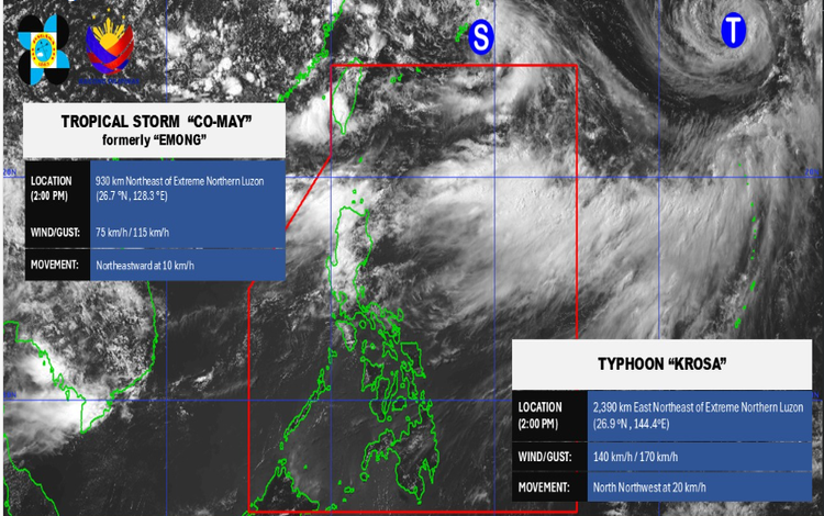
As of 3:00 PM today, two tropical cyclones are being monitored by PAGASA:
- Tropical Storm Co-may (formerly “Emong”) was located 920 kilometers northeast of extreme northern Luzon, with maximum sustained winds of 75 km/h and gusts reaching 115 km/h. It is moving northeastward at 10 kilometers per hour.
- Typhoon Krosa, the stronger of the two, was spotted 2,385 kilometers east-northeast of extreme northern Luzon. It packs maximum sustained winds of 140 km/h with gustiness up to 170 km/h and is moving north-northwestward at 20 km/h.
Although these cyclones are not expected to affect the country directly, they continue to enhance the Southwest Monsoon, resulting in significant rainfall over various regions.
Forecast Weather Conditions
- Ilocos Region, Batanes, Babuyan Islands, Abra, Benguet, Zambales, and Bataan are expected to experience occasional rains due to the monsoon. Residents in these areas should be on alert for possible floods and landslides.
- Metro Manila, CALABARZON, Occidental and Oriental Mindoro, Marinduque, the rest of the Cordillera Administrative Region, Cagayan Valley, and Central Luzon will have cloudy skies with scattered rains and thunderstorms, also due to the Southwest Monsoon. These areas face moderate to, at times, heavy rains, increasing the risk of flash floods and landslides.
- The rest of the country will see partly cloudy to cloudy skies with isolated rain showers or thunderstorms. While less intense, severe thunderstorms may still cause localized flooding or landslides.
Wind and Coastal Water Conditions
- In extreme northern Luzon, strong southwesterly winds will result in rough seas with waves reaching 2.8 to 4.0 meters. Fishing boats and small seacraft are advised not to venture out.
- In the western section of Luzon, moderate to strong southwest winds will create moderate to rough seas with waves between 2.1 to 3.4 meters.
Rainfall Outlook
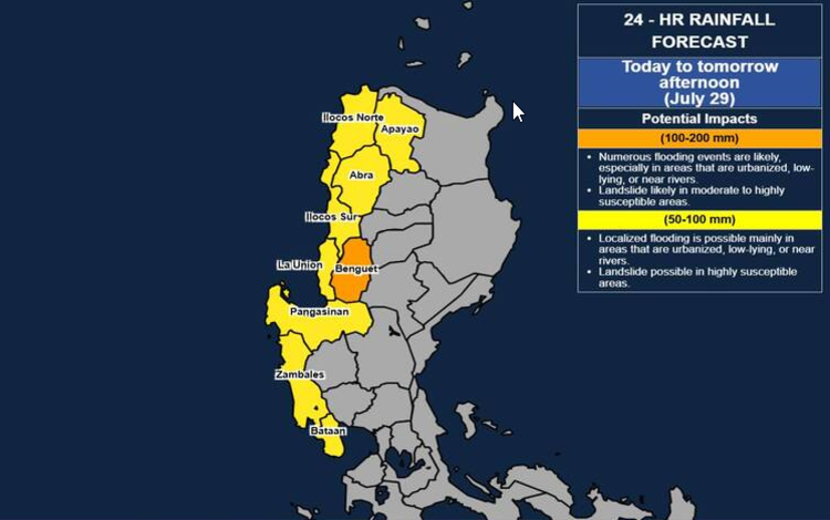
- Today until tomorrow afternoon (July 29):
- Benguet may receive 100-200 mm of rainfall.
- Ilocos Region, Abra, Apayao, Zambales, and Bataan may see 50-100 mm.
- Tomorrow afternoon to July 30 afternoon:
- Ilocos Norte, Ilocos Sur, La Union, Abra, and Benguet will likely get 50-100 mm.
Higher rainfall totals are expected in mountainous regions, and areas previously soaked by recent rains are more susceptible to hazards.
Advisories
General Flood Advisories have been issued for:
- Cordillera Administrative Region (GFA #4)
- Ilocos Region (GFA #25)
- Central Luzon (GFA #27)
PAGASA advises local government units and disaster management offices to prepare accordingly and monitor further updates.