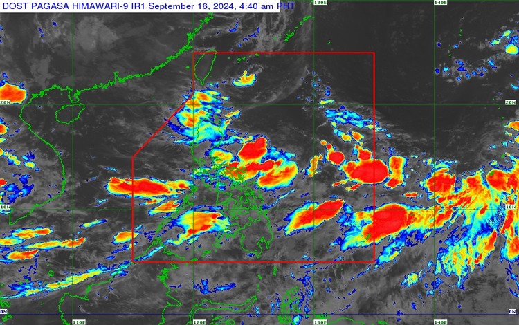
As of 3:00 AM today, September 16, 2024, the Low-Pressure Area (LPA) was located approximately 375 kilometers east-northeast of Casiguran, Aurora, or 400 kilometers east of Tuguegarao City, Cagayan. The LPA continues to influence weather conditions across Luzon, while the Southwest Monsoon is affecting Southern Luzon, the Visayas, and Mindanao.
Tropical Storm “PULASAN”
As of 3:00 AM, Tropical Storm “Pulasan” was situated 2,205 kilometers east of Southeastern Luzon, outside the Philippine Area of Responsibility (PAR). The storm’s maximum sustained winds are 65 km/h, with gusts reaching up to 80 km/h. It is currently moving north-northeastward at 20 km/h. “Pulasan” is expected to enter PAR by tomorrow evening and may exit by Wednesday morning, though changes in its trajectory remain possible. Despite its presence, the storm is not anticipated to directly affect the Philippines during the forecast period.
Weather Conditions Forecast
- The Northern Portion of Palawan, Occidental Mindoro, Aklan, Antique, and Negros Occidental
- Weather: Monsoon rains
- Caused by: Southwest Monsoon
- Impacts: Possible flash floods or landslides due to heavy to intense rainfall.
- Rest of MIMAROPA, Western Visayas, and Negros Island Region
- Weather: Occasional rains
- Caused by: Southwest Monsoon
- Impacts: Flash floods or landslides may occur due to moderate to heavy rains.
- Ilocos Region, Cordillera Administrative Region, Cagayan Valley, and Aurora
- Weather: Cloudy skies with scattered rains and thunderstorms
- Caused by: LPA
- Impacts: Potential flash floods or landslides from moderate to heavy rainfall.
- Metro Manila, Zamboanga Peninsula, BARMM, SOCCSKSARGEN, Caraga, Northern Mindanao, and the rest of Luzon and Visayas
- Weather: Cloudy skies with scattered rains and thunderstorms
- Caused by: Southwest Monsoon
- Impacts: Flash floods or landslides due to moderate to heavy rainfall.
- Rest of Mindanao
- Weather: Partly cloudy to cloudy skies with isolated rain showers or thunderstorms
- Caused by: Southwest Monsoon
- Impacts: Possible flash floods or landslides during severe thunderstorms.
Wind and Coastal Water Conditions
- Visayas, Western-Southern Luzon, and the western, northern, and eastern sections of Mindanao
- Wind: Strong, from the southwest
- Coastal Waters: Rough, 2.8 to 4.0 meters.
- Rest of Southern Luzon and Mindanao
- Wind: Moderate to strong
- Coastal Waters: Moderate to rough, 2.1 to 3.7 meters.
- Rest of Luzon
- Wind: Light to moderate, northeast to northwest
- Coastal Waters: Slight to moderate, 0.6 to 2.5 meters.
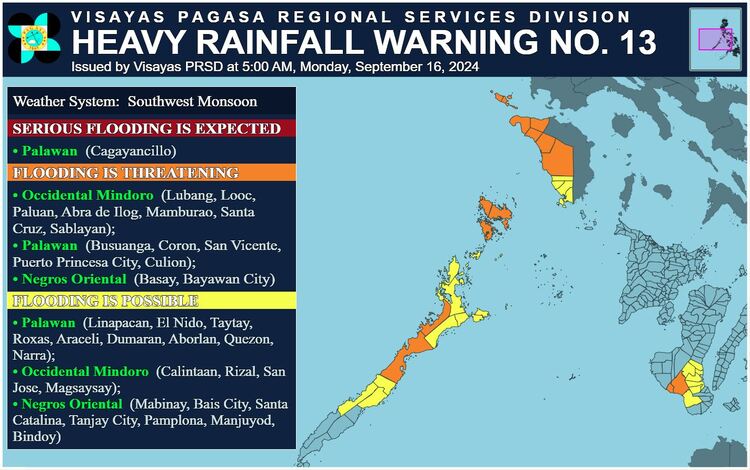
Heavy Rainfall Warnings
- RED Warning: Palawan (Cagayancillo) — Serious flooding and landslides are expected in low-lying and mountainous areas.
- ORANGE Warning: Occidental Mindoro, parts of Palawan, Negros Oriental — Flooding is threatening, and landslides are possible.
- YELLOW Warning: Palawan, Occidental Mindoro, Negros Oriental — Flooding is possible in low-lying areas, with landslides in mountainous areas.
Flood advisories have been issued across various regions, warning of potential flooding due to heavy monsoon rains.