The Philippine Atmospheric, Geophysical, and Astronomical Services Administration (PAGASA) has issued its weather forecast for Friday, February 14, 2025, highlighting the influence of multiple weather systems across the country.
Weather Systems Affecting the Philippines:
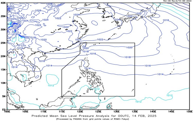
- Shear Line: Currently impacting Extreme Northern Luzon, bringing cloudy skies with scattered rains and isolated thunderstorms to areas such as Batanes and the Babuyan Islands. Residents in these regions should be vigilant for possible flash floods or landslides due to moderate to occasionally heavy rainfall.
- Easterlies: These warm and humid winds from the Pacific Ocean are affecting the eastern sections of Luzon and Visayas. Regions including the Bicol Region, Eastern Visayas, Mainland Cagayan, Isabela, Aurora, and Quezon can expect cloudy skies accompanied by scattered rains and thunderstorms. The public is advised to remain alert for potential flash floods or landslides resulting from moderate to heavy rains.
- Intertropical Convergence Zone (ITCZ): Influencing Mindanao, the ITCZ is causing cloudy skies with scattered rains and thunderstorms in Northern Mindanao, Caraga, and the Davao Region. Similar to other affected areas, there is a risk of flash floods or landslides during periods of moderate to heavy rainfall.
Regional Weather Conditions:
- Batanes and Babuyan Islands: Anticipate cloudy skies with scattered rains and isolated thunderstorms due to the Shear Line.
- Bicol Region, Eastern Visayas, Mainland Cagayan, Isabela, Aurora, and Quezon: These areas will experience cloudy skies with scattered rains and thunderstorms, influenced by the Easterlies.
- Northern Mindanao, Caraga, and Davao Region: Expect cloudy skies with scattered rains and thunderstorms as a result of the ITCZ.
- Rest of Mindanao: Partly cloudy to cloudy skies with isolated rain showers or thunderstorms are expected. Residents should be cautious of possible flash floods or landslides during severe thunderstorms.
- Metro Manila and the Rest of the Country: Generally, partly cloudy to cloudy skies with isolated rain showers or thunderstorms will prevail, primarily due to the influence of the Easterlies. The public is advised to remain alert for potential flash floods or landslides during severe thunderstorms.
Wind and Coastal Water Conditions:
- Extreme Northern Luzon: Strong winds blowing from the northeast will result in rough coastal waters, with wave heights ranging from 2.8 to 4.0 meters.
- Rest of Northern Luzon: Moderate to strong winds from the southeast to northeast are expected, leading to moderate to rough seas with wave heights between 2.1 to 3.5 meters.
- Rest of the Country: Light to moderate winds prevailing from the east to northeast will cause slight to moderate coastal waters, with wave heights ranging from 0.6 to 2.5 meters.
General Flood Advisories:
As of 6:00 AM on February 14, 2025, PAGASA has issued General Flood Advisories for several regions due to prevailing weather conditions:
- Cordillera Administrative Region (CAR): GFA#2
- Region 2 (Cagayan Valley): GFA#4
- Region 3 (Central Luzon): GFA#14
- Region 4A (CALABARZON): GFA#15
- Region 4B (MIMAROPA): GFA#16 Final
- Region 5 (Bicol Region): GFA#17
- Region 8 (Eastern Visayas): GFA#18
- Region 10 (Northern Mindanao): GFA#3
- Region 11 (Davao Region): GFA#4
- Region 13 (Caraga): GFA#25
- Bangsamoro Autonomous Region in Muslim Mindanao (BARMM): GFA#4
Residents in these areas, especially those near mountain slopes and low-lying regions, are advised to take necessary precautions against possible flash floods and landslides.
Low-Pressure Area (LPA) Update:
As of 8:00 AM today, a Low-Pressure Area (LPA 02a) located outside the Philippine Area of Responsibility (PAR) has a low chance of developing into a tropical depression within the next 24 hours.
PAGASA continues to monitor the situation and advises the public to stay updated through official channels for any changes in weather conditions.