The Philippine Atmospheric, Geophysical, and Astronomical Services Administration (PAGASA) has issued a weather forecast for February 19, 2025, highlighting the influence of multiple weather systems across the country. The Shear Line is affecting the eastern sections of Northern and Central Luzon, the Northeast Monsoon is impacting the rest of Northern Luzon, and the Intertropical Convergence Zone (ITCZ) is influencing Southern Mindanao.
Weather Conditions and Affected Areas
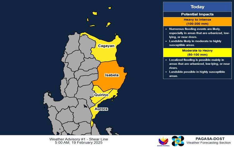
- Mainland Cagayan, Isabela, Quirino, and Aurora: These areas are expected to experience cloudy skies with scattered rains and isolated thunderstorms due to the Shear Line. Residents should remain vigilant for possible flash floods or landslides resulting from moderate to heavy rains.
- Cordillera Administrative Region and the rest of Cagayan Valley: The Northeast Monsoon is bringing cloudy skies with rains to these regions. The public is advised to watch for potential flash floods or landslides caused by moderate to occasionally heavy rainfall.
- Zamboanga Peninsula, Palawan, Basilan, Sulu, and Tawi-Tawi: Influenced by the ITCZ, these areas will have cloudy skies with scattered rains and thunderstorms. There is a risk of flash floods or landslides due to moderate to at times heavy rains.
- Eastern Visayas, Caraga, Sorsogon, and Davao Oriental: Easterlies are causing cloudy skies with scattered rains and thunderstorms in these regions. Residents should be cautious of possible flash floods or landslides during periods of moderate to occasionally heavy rains.
- Ilocos Region: This region will experience partly cloudy to cloudy skies with isolated light rains due to the Northeast Monsoon. No significant impacts are expected.
- Metro Manila and the rest of the country: Partly cloudy to cloudy skies with isolated rain showers or thunderstorms are anticipated, influenced by Easterlies. While severe thunderstorms are possible, they may lead to flash floods or landslides in certain areas.
Wind and Coastal Water Conditions
- Northern Luzon and the eastern sections of Central and Southern Luzon: Moderate to strong winds from the northeast are expected, with coastal waters ranging from moderate to rough (2.1 to 4.0 meters). Mariners should exercise caution due to these conditions.
- The rest of the country: Light to moderate winds blowing from the northeast will prevail, with slight to moderate coastal waters (0.6 to 2.5 meters).
General Flood Advisories
As of 6:00 AM on February 19, 2025, PAGASA has issued General Flood Advisories for the following regions:
- Region 2 (Cagayan Valley): GFA#14
- Region 4B (MIMAROPA): GFA#2
- Region 9 (Zamboanga Peninsula): GFA#3
- Region 12 (SOCCSKSARGEN): GFA#7
- BARMM (Bangsamoro Autonomous Region in Muslim Mindanao): GFA#4
Residents in these areas are advised to take necessary precautions against potential flooding.
Heavy Rainfall Outlook Due to Shear Line
- Today:
- Heavy to Intense (100-200 mm): Isabela
- Moderate to Heavy (50-100 mm): Cagayan, Quirino, and Aurora
- Tomorrow:
- Moderate to Heavy (50-100 mm): Isabela, Aurora, Catanduanes, Albay, Sorsogon, Northern Samar, Eastern Samar, Southern Leyte, Dinagat Islands, and Surigao del Norte
- Friday (February 21):
- Moderate to Heavy (50-100 mm): Sorsogon, Masbate, Northern Samar, Eastern Samar, Samar, Biliran, Leyte, Southern Leyte, Dinagat Islands, and Surigao del Norte
It’s important to note that actual rainfall may be higher in mountainous and elevated areas. Additionally, previous significant rainfall may exacerbate impacts in some regions.
Public Advisory
PAGASA advises the public and local disaster risk reduction and management offices to implement necessary measures to safeguard life and property. Regional Services Divisions of PAGASA may issue Heavy Rainfall Warnings, Rainfall/Thunderstorm Advisories, and other severe weather information specific to their areas as needed.
The next Weather Advisory is scheduled for release at 11:00 AM today unless significant changes occur.
Understanding Weather Alerts
A key distinction exists between a Heavy Rainfall Warning and a Weather Advisory:
- Heavy Rainfall Warning: Provides forecasts for the next three hours and applies up to the municipal level. It is more precise, utilizing Doppler radar technology to track real-time rainfall intensity, making it highly effective for immediate decision-making in flood-prone areas.