The Philippine Atmospheric, Geophysical, and Astronomical Services Administration (Pagasa) issued its latest weather bulletin as of 5:00 AM today, December 19, 2024. The Low-Pressure Area (LPA), previously identified as “Querubin,” was last located at 245 km east of Surigao City, Surigao del Norte (9.8°N, 127.7°E). Its presence, alongside the Shear Line and the Northeast Monsoon, continues influencing the country’s weather conditions.
Weather Conditions and Affected Areas
Eastern Visayas and Caraga
- Weather: Cloudy skies with scattered rain showers and thunderstorms.
- Cause: Low-Pressure Area (LPA).
- Impacts: Potential flash floods or landslides due to moderate to heavy, and at times intense, rainfall.
Rest of Visayas and Mindanao
- Weather: Cloudy skies with scattered rain showers and thunderstorms.
- Cause: Trough of the LPA.
- Impacts: Risk of flash floods or landslides due to moderate to heavy, and at times intense, rainfall.
Bicol Region and Quezon
- Weather: Cloudy skies with scattered rain showers and thunderstorms.
- Cause: Shear Line.
- Impacts: Potential flash floods or landslides due to moderate to heavy rains.
Cagayan Valley, Cordillera Administrative Region, Aurora, Oriental Mindoro, Marinduque, and Romblon
- Weather: Cloudy skies with light rains.
- Cause: Northeast Monsoon.
- Impacts: No significant effect is expected.
Metro Manila and the Rest of Luzon
- Weather: Partly cloudy to cloudy skies with isolated light rains.
- Cause: Northeast Monsoon.
- Impacts: No significant effect is anticipated.
Forecast Wind and Coastal Water Conditions
- Northern and Western Sections of Northern Luzon
- Wind Speed: Strong to Gale
- Wind Direction: Northeast
- Coastal Waters: Rough to rough, with wave heights between 2.8 and 4.5 meters.
- Eastern Section of the Country
- Wind Speed: Moderate to Strong
- Wind Direction: Northeast
- Coastal Waters: Moderate to rough, with wave heights between 2.5 to 4.0 meters.
- Rest of the Country
- Wind Speed: Light to Moderate
- Wind Direction: Northeast to Northwest
- Coastal Waters: Slight to moderate, with wave heights ranging from 0.6 to 2.5 meters.
Heavy Rainfall Outlook
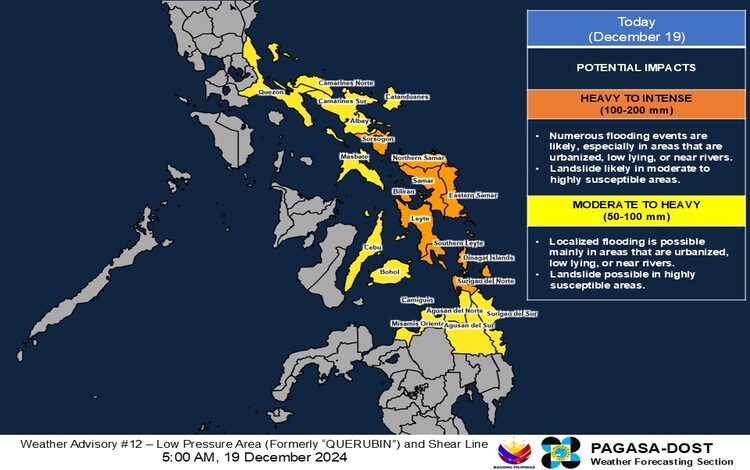
Today (December 19, 2024)
- Heavy to Intense Rainfall (100-200 mm):
- Sorsogon, Northern Samar, Eastern Samar, Samar, Biliran, Leyte, Southern Leyte, Dinagat Islands, and Surigao del Norte.
- Moderate to Heavy Rainfall (50-100 mm):
- Quezon, Camarines Norte, Camarines Sur, Catanduanes, Albay, Masbate, Cebu, Bohol, Camiguin, Misamis Oriental, Agusan del Norte, Agusan del Sur, and Surigao del Sur.
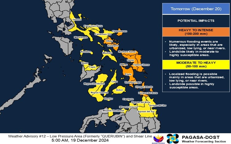
Tomorrow (December 20, 2024)
- Heavy to Intense Rainfall (100-200 mm):
- Catanduanes, Albay, Sorsogon, Northern Samar, Eastern Samar, Samar, Biliran, Leyte, Southern Leyte, Dinagat Islands, and Surigao del Norte.
- Moderate to Heavy Rainfall (50-100 mm):
- Quezon, Marinduque, Romblon, Camarines Norte, Camarines Sur, Masbate, Aklan, Capiz, Negros Occidental, Negros Oriental, Siquijor, Cebu, Bohol, Misamis Occidental, Misamis Oriental, Camiguin, Agusan del Norte, Agusan del Sur, and Surigao del Sur.
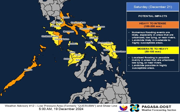
Saturday (December 21, 2024)
- Heavy to Intense Rainfall (100-200 mm):
- Quezon, Camarines Norte, Camarines Sur, Oriental Mindoro, Marinduque, and Palawan.
- Moderate to Heavy Rainfall (50-100 mm):
- Laguna, Batangas, Occidental Mindoro, Romblon, Catanduanes, Albay, Sorsogon, Masbate, Antique, Aklan, Capiz, Iloilo, Northern Samar, Eastern Samar, and Samar.