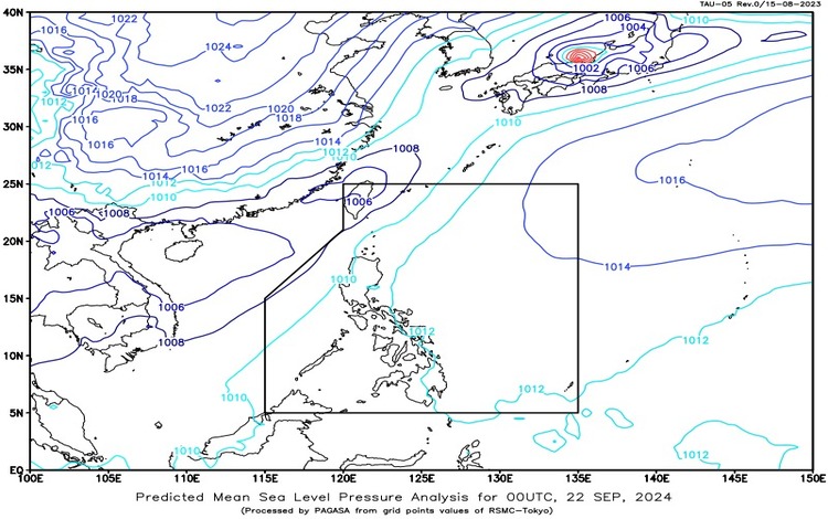
The Philippine Atmospheric, Geophysical, and Astronomical Services Administration (PAGASA) reported that the southwest monsoon is affecting Northern Luzon. Additionally, a tropical depression (formerly named “Igme”) is located outside the Philippine Area of Responsibility (PAR). This tropical depression is positioned approximately 535 kilometers north-northwest of Itbayat, Batanes, at coordinates 25.5°N, 120.8°E. The system is packing maximum sustained winds of 55 kilometers per hour (km/h) near its center, with gustiness reaching up to 70 km/h. The tropical depression is moving westward at a speed of 15 km/h.
Forecast Weather Conditions
Ilocos Region, Batanes, and Babuyan Islands:
Residents in the Ilocos Region, Batanes, and Babuyan Islands can expect cloudy skies with scattered rains and thunderstorms. This weather pattern is being caused by the southwest monsoon. Due to the moderate to at times heavy rains, there is a possibility of flash floods or landslides in the affected areas.
Cordillera Administrative Region and the rest of Cagayan Valley:
The Cordillera Administrative Region (CAR) and other parts of Cagayan Valley will experience partly cloudy to cloudy skies with isolated rain showers or thunderstorms, also attributed to the southwest monsoon. Though rainfall is generally lighter in these areas, severe thunderstorms may still lead to flash floods or landslides.
Metro Manila and the rest of the country:
In Metro Manila and the rest of the Philippines, weather conditions will mostly be partly cloudy to cloudy with isolated rain showers or thunderstorms caused by localized thunderstorms. Although these thunderstorms are generally isolated, they can still result in flash floods or landslides in low-lying or flood-prone areas.
Wind and Coastal Water Conditions
Northern and western sections of Northern Luzon:
Strong winds coming from the south are expected to affect the northern and western sections of Northern Luzon. Coastal waters in these regions will be rough, with wave heights ranging from 2.8 to 4.0 meters. Sea travel may be risky, especially for small sea vessels.
Rest of Luzon:
The rest of Luzon will experience moderate to strong winds from the southeast to the south, with coastal waters remaining moderate to rough. Wave heights are expected to range from 1.2 to 2.8 meters.
Tropical Depression Update
The tropical depression formerly known as “Igme” remains outside of PAR. It is currently located 535 kilometers north-northwest of Itbayat, Batanes. With maximum sustained winds of 55 km/h near the center and gustiness reaching 70 km/h, the system is slowly moving westward at 15 km/h. While it remains outside PAR, it may still influence weather patterns in Northern Luzon due to its proximity to the area.
General Flood Advisories
As of 6:00 AM today, the following regions are under general flood advisories due to the impacts of the southwest monsoon and localized thunderstorms:
- Region 1 (Ilocos Region): General Flood Advisory #6
- Region 2 (Cagayan Valley): General Flood Advisory #6 (Final)
- Region 3 (Central Luzon): General Flood Advisory #19
- Region 4A (CALABARZON): General Flood Advisory #19 (Final)
- Region 4B (MIMAROPA): General Flood Advisory #21 (Final)
- Cordillera Administrative Region (CAR): General Flood Advisory #5
Residents in these regions are advised to stay updated on the latest weather bulletins and exercise caution, especially in areas prone to flooding and landslides. PAGASA will continue to monitor the weather systems and issue necessary updates.
Safety Precautions
Due to the potential risks of flash floods, landslides, and rough sea conditions, the public is urged to take precautionary measures, particularly those living in low-lying or mountainous areas. Fisherfolk and small sea vessels are advised to avoid venturing to sea in regions experiencing rough seas.