The Philippine Atmospheric, Geophysical and Astronomical Services Administration (PAGASA) released its weather forecast for Monday, January 26, 2026, highlighting the combined effects of the Shear Line and the Northeast Monsoon (Amihan) across large parts of the country. Several areas, particularly in the eastern sections of the Visayas and Mindanao, are advised to remain alert due to the risk of heavy rainfall and possible flooding.
According to PAGASA, the Shear Line continues to affect Caraga, Eastern Visayas, Central Visayas, Sorsogon, Masbate, Camiguin, and Misamis Oriental. Residents in these areas can expect generally cloudy skies accompanied by scattered rains and isolated thunderstorms. Moderate to heavy rainfall may trigger flash floods or landslides, especially in low-lying, coastal, and mountainous locations. Authorities are urging local disaster risk reduction and management offices to take precautionary measures to protect lives and property.
Meanwhile, the Northeast Monsoon is influencing Cagayan Valley, the rest of the Visayas, the remaining parts of the Bicol Region, and several provinces in Luzon, including Apayao, Kalinga, Mountain Province, Ifugao, Aurora, Quezon, Oriental Mindoro, Marinduque, and Romblon. These areas are expected to experience cloudy skies with light rain. PAGASA noted that no significant weather-related impacts are anticipated in these locations, although residents are still advised to stay informed of updates.
Metro Manila and the rest of Luzon will have partly cloudy to cloudy skies with isolated light rains, also due to the Northeast Monsoon. Weather conditions in these areas are generally manageable, with no major hazards expected. In contrast, the rest of Mindanao may experience partly cloudy to cloudy skies with isolated rain showers or thunderstorms caused by localized weather systems. During severe thunderstorms, flash floods or landslides remain possible.
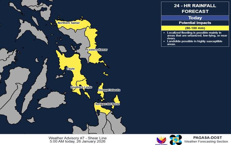
PAGASA also issued a heavy rainfall outlook associated with the Shear Line. Rainfall amounts of 50 to 100 millimeters are expected today in Northern Samar, Eastern Samar, Southern Leyte, Leyte, Dinagat Islands, and Surigao del Norte. Rainfall totals may be higher in mountainous and elevated areas, and impacts could worsen due to significant antecedent rainfall in recent days.
Wind and coastal water conditions remain unfavorable in several regions. Strong winds from the northeast to north will affect the eastern sections of the Visayas and Mindanao, resulting in rough seas with wave heights reaching 2.8 to 4.0 meters. Northern and eastern sections of Luzon will experience moderate to strong winds and moderate to rough coastal waters, while the rest of the country will see moderate to strong winds with moderate to rough seas.
PAGASA emphasized the importance of understanding weather alerts. Heavy Rainfall Warnings provide short-term, highly accurate forecasts at the municipal level, while Weather Advisories offer a broader 24-hour outlook at the provincial level. A General Flood Advisory is currently in effect in multiple regions, including Bicol, Central and Eastern Visayas, Northern Mindanao, Caraga, BARMM, and parts of Mindanao.