The Philippine Atmospheric, Geophysical and Astronomical Services Administration (PAGASA) has issued its latest forecast, warning of widespread rains over several parts of the country due to the combined effects of a Low Pressure Area (LPA) and the Southwest Monsoon. The advisory covers rainfall outlook, weather conditions, flood warnings, and coastal water updates for the next three days.
Heavy Rainfall Outlook Due to LPA
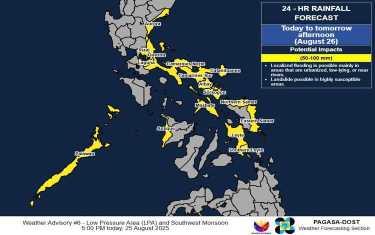
As of 6:00 PM on August 25, the LPA was located 290 km northeast of Maasin City, Southern Leyte, or 130 km east-northeast of Borongan City, Eastern Samar (12.2°N, 126.5°E). The system continues to enhance rain activity across many provinces.
From today until tomorrow afternoon (August 26), heavy rains ranging from 50 to 100 mm are expected over Aurora, Quezon, Laguna, Rizal, Camarines Norte, Camarines Sur, Albay, Sorsogon, Catanduanes, Masbate, Northern Samar, Eastern Samar, Leyte, and Southern Leyte.
By tomorrow afternoon until Wednesday afternoon (August 27), rainfall of similar intensity is forecast in Aurora, Bulacan, Quezon, Nueva Ecija, Rizal, Camarines Norte, Camarines Sur, Catanduanes, Albay, and Sorsogon. PAGASA noted that precipitation may be stronger in mountainous and elevated areas, with potential flooding and landslides in highly saturated zones.
Southwest Monsoon-Enhanced Rains
In addition to the LPA, the Southwest Monsoon (Habagat) is expected to bring sustained rains over the western parts of the country. From today to tomorrow afternoon, Palawan and Antique will receive moderate to heavy rains (50–100 mm).
Between tomorrow afternoon and Wednesday afternoon, Occidental Mindoro, Palawan, Antique, and Negros Occidental will experience similar rainfall amounts. By Wednesday afternoon through Thursday afternoon (August 28), rains will persist over Palawan, Antique, and Occidental Mindoro.
Forecast Weather Conditions
- Zamboanga Peninsula, BARMM, SOCCSKSARGEN, MIMAROPA, and Antique: Cloudy skies with scattered rainshowers and thunderstorms due to the Southwest Monsoon. Possible flash floods and landslides.
- Metro Manila, Cagayan Valley, Cordillera Administrative Region, Central Luzon, CALABARZON, Bicol Region, Northern Mindanao, Caraga, and the rest of Visayas: Cloudy skies with scattered rains caused by the LPA, with risks of flooding and landslides.
- The rest of the country: Partly cloudy to cloudy skies with isolated thunderstorms caused by localized weather systems.
Wind and Coastal Waters
- Northern and Central Luzon: Moderate winds from the east to northeast; seas moderate at 1.2–1.8 meters.
- Eastern section of Southern Luzon: Moderate winds from southeast to northeast; seas moderate at 1.2–1.8 meters.
- Rest of Southern Luzon: Light to moderate winds from southwest to northwest; seas slight to moderate at 0.6–1.8 meters.
General Flood Advisories
Flood advisories remain active in multiple regions, including CAR (#4), CALABARZON (#10), MIMAROPA (#12), Eastern Visayas (#15), Western Visayas (#11), and BARMM (#13). Local government units and Disaster Risk Reduction and Management Offices are urged to take precautionary measures.
Public Advisory
PAGASA reminds residents in affected areas to remain vigilant for sudden flooding and landslides, particularly in low-lying and mountainous areas. Heavy Rainfall Warnings and Thunderstorm Advisories will be issued as conditions develop.