The Philippine Atmospheric, Geophysical, and Astronomical Services Administration (Pagasa) continues to monitor the weather patterns affecting the country. The Southwest Monsoon, locally known as Habagat, is bringing heavy rains over large parts of Southern Luzon, Visayas, and Mindanao. Meanwhile, Tropical Storm Bebinca (formerly Ferdie), located outside the Philippine Area of Responsibility (PAR), is influencing weather conditions in other regions as its trough affects Luzon.
Tropical Storm Bebinca Update
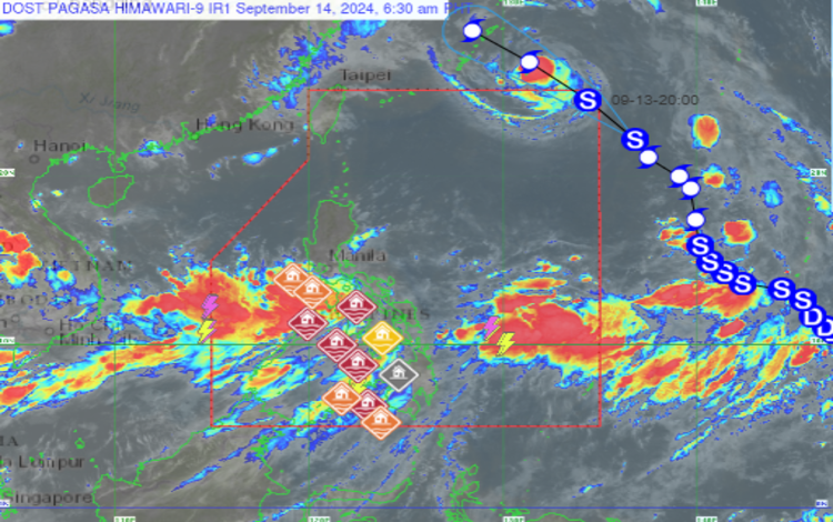
Tropical Storm Bebinca, which was previously known as “Ferdie,” has been upgraded and is now situated 1,215 kilometers east-northeast of Extreme Northern Luzon, at coordinates 25.4°N, 132.6°E. The storm has maximum sustained winds of 85 kilometers per hour (km/h) and gustiness up to 105 km/h. It is currently moving west-northwestward at a speed of 20 km/h. Despite being outside PAR, Bebinca’s trough is affecting the weather conditions in various parts of the country, especially in Luzon.
In addition, Pagasa is also monitoring two more weather disturbances that can potentially develop into low-pressure areas (LPAs). These systems may further influence weather conditions in the days ahead.
Forecast Weather Conditions
- MIMAROPA, Western Visayas, and Negros Occidental
- Weather: Monsoon rains
- Cause: Southwest Monsoon
- Impact: Expect heavy, intense rains that could lead to flash floods or landslides in flood-prone or mountainous areas.
- Bicol Region and the Rest of Negros Island Region
- Weather: Occasional rains
- Cause: Southwest Monsoon
- Impact: Moderate to heavy rains may cause flash floods or landslides.
- Metro Manila, the Rest of Visayas, Zamboanga Peninsula, BARMM, SOCCSKSARGEN, Caraga, Northern Mindanao, CALABARZON, Zambales, and Bataan
- Weather: Cloudy skies with scattered rains and thunderstorms
- Cause: Southwest Monsoon
- Impact: Moderate to at times heavy rains, with the risk of flash floods or landslides.
- The Rest of Mindanao
- Weather: Partly cloudy to cloudy skies with isolated rain showers or thunderstorms
- Cause: Southwest Monsoon
- Impact: Localized thunderstorms may bring flash floods or landslides, especially during intense downpours.
- The Rest of Luzon
- Weather: Partly cloudy to cloudy skies with isolated rain showers or thunderstorms
- Cause: Trough of Tropical Storm Bebinca
- Impact: Severe thunderstorms could trigger flash floods or landslides in vulnerable areas.
Wind and Coastal Water Conditions
- Western sections of Southern Luzon and Visayas:
Strong winds from the southwest will create rough seas, with waves reaching between 2.8 and 4.0 meters. - Mindanao and the rest of Southern Luzon and Visayas:
Winds will range from moderate to strong, with coastal waters becoming moderate to rough, and wave heights between 2.1 to 3.4 meters. - The Rest of Luzon:
Light to moderate winds from the north to northwest will prevail, with coastal waters ranging from slight to moderate at 0.6 to 2.5 meters.
General Flood Advisories
As of 6:00 AM today, Pagasa has issued flood advisories across multiple regions:
- Region 3 (Central Luzon): GFA#3
- Region 4A (CALABARZON): GFA#3
- Region 4B (MIMAROPA): GFA#5
- Region 5 (Bicol Region): GFA#7
- Region 6 (Western Visayas): GFA#3
- Region 7 (Central Visayas): GFA#3
- Region 8 (Eastern Visayas): GFA#7
- Region 9 (Zamboanga Peninsula): GFA#4
- Region 12 (SOCCSKSARGEN): GFA#4
- Region 13 (Caraga): GFA#8 (Final)
- BARMM (Bangsamoro Autonomous Region in Muslim Mindanao): GFA#4
Residents in these regions are advised to remain vigilant for possible flooding, especially in low-lying areas and along rivers. Pagasa will continue to monitor weather conditions and issue updates as needed. For safety, heed local authorities’ warnings and stay tuned to official announcements.