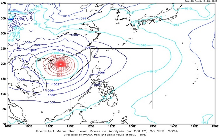
SYNOPSIS: As of September 6, 2024, the trough of Super Typhoon Yagi (formerly known as “Enteng”) is affecting Extreme Northern Luzon, while the Southwest Monsoon continues to impact the rest of Luzon. Super Typhoon Yagi remains outside the Philippine Area of Responsibility (PAR), located 825 kilometers west of Northern Luzon at coordinates 19.2°N, and 112.8°E. It packs maximum sustained winds of 195 km/h with gusts reaching up to 240 km/h and is moving westward at 20 km/h.
Tropical Cyclone Outside PAR:
- Name: Super Typhoon Yagi (formerly “Enteng”)
- Location (as of 3:00 AM): 825 km west of Northern Luzon (19.2°N, 112.8°E)
- Maximum Sustained Winds: 195 km/h
- Gustiness: Up to 240 km/h
- Movement: Westward at 20 km/h
Forecast Weather Conditions:
- Pangasinan, Zambales, and Bataan:
- Weather: Occasional rains
- Cause: Southwest Monsoon
- Impacts: Possible flash floods or landslides due to moderate to heavy rains.
- Batanes and Babuyan Islands:
- Weather: Cloudy skies with scattered rains and thunderstorms
- Cause: Trough of Super Typhoon Yagi
- Impacts: Possible flooding or landslides due to moderate to heavy rains.
- Metro Manila, Cordillera Administrative Region (CAR), CALABARZON, MIMAROPA, and the rest of Ilocos Region and Central Luzon:
- Weather: Cloudy skies with scattered rains and thunderstorms
- Cause: Southwest Monsoon
- Impacts: Possible flash floods or landslides due to moderate to heavy rains.
- The Rest of the Country:
- Weather: Localized thunderstorms
- Cause: Localized thunderstorms
- Impacts: Possible flash floods or landslides during severe thunderstorms.
Forecast Wind and Coastal Water Conditions:
- Western Section of Luzon:
- Wind Speed: Strong
- Wind Direction: Southwest to South
- Coastal Waters: Rough (2.8 to 4.5 meters)
- Rest of Luzon:
- Wind Speed: Moderate to Strong
- Wind Direction: Southwest to Southeast
- Coastal Waters: Moderate to Rough (1.5 to 2.8 meters)
- Visayas and Mindanao:
- Wind Speed: Light to Moderate
- Wind Direction: South to Southwest
- Coastal Waters: Slight to Moderate (0.6 to 2.5 meters)
Regional Weather Forecasts:
- Palawan (including Kalayaan Islands) and Occidental Mindoro:
- Weather: Cloudy skies with scattered rains and thunderstorms
- Cause: Southwest Monsoon
- Wind Speed: Moderate to Strong
- Wind Direction: Southwest to Southeast
- Seas: Moderate to Rough
- Visayas:
- Weather: Partly cloudy to cloudy skies with isolated rain showers or thunderstorms
- Cause: Localized thunderstorms
- Wind Speed: Light to Moderate
- Wind Direction: South to Southwest
- Seas: Slight to Moderate
Heavy Rainfall Warnings:
- Orange Warning Level:
- Areas: Zambales, Bataan
- Hazard: Flooding is still threatening.
- Yellow Warning Level:
- Areas: Tarlac, Pampanga, Nueva Ecija
- Hazard: Flooding in flood-prone areas.
- Light to moderate rains are expected over Rizal and Laguna within the next 3 hours.
- Bulacan, Cavite, Batangas, and Metro Manila are experiencing light to moderate rains that may persist within 3 hours.
General Flood Advisories:
- Cordillera Administrative Region (CAR): GFA#9
- Ilocos Region (Region 1): GFA#11
- Cagayan Valley (Region 2): GFA#10 Final
- Central Luzon (Region 3): GFA#12
- CALABARZON (Region 4A): GFA#12
- MIMAROPA (Region 4B): GFA#29
Residents in these areas are advised to stay vigilant and monitor updates, as the weather systems may bring significant rainfall and cause flooding or landslides. Coastal waters in the affected areas may also be rough, particularly along the western section of Luzon.