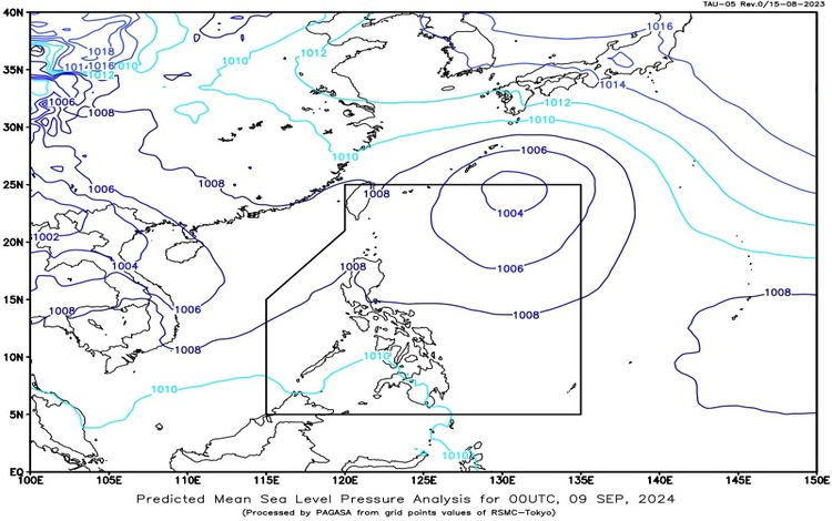
SYNOPSIS: The Southwest Monsoon, locally known as “Habagat,” continues to influence Luzon today. At 3:00 AM, a Low-Pressure Area (LPA) was located approximately 1,155 kilometers East-Northeast of Extreme Northern Luzon, at coordinates 24.0°N, 132.5°E. While this LPA does not currently pose a direct threat, it contributes to the overall weather pattern across the Philippines.
Forecast Weather Conditions:
- Ilocos Region, Apayao, and Abra: The region will experience occasional rains due to the Southwest Monsoon. Residents should be cautious of flooding or landslides from moderate to heavy rains. Authorities are advising people in flood-prone and landslide-prone areas to stay vigilant.
- Cagayan Valley, Central Luzon, and the rest of the Cordillera Administrative Region: Cloudy skies with scattered rains and thunderstorms are expected. The Southwest Monsoon is responsible for these conditions, which may lead to possible flooding or landslides due to moderate to sometimes heavy rains. The public should be prepared for sudden weather changes and potential hazards.
- Metro Manila, CALABARZON, MIMAROPA, and Bicol Region: These areas will see partly cloudy to cloudy skies with isolated rain showers or thunderstorms. While the chances of severe weather are lower, there remains a risk of flash floods or landslides, particularly during intense thunderstorms. Residents are advised to monitor weather updates and be prepared for quick changes.
- The rest of the country: Expect partly cloudy to cloudy skies with isolated rain showers or thunderstorms. Localized thunderstorms may cause flash floods or landslides, especially during severe weather conditions. It’s important to stay informed about local weather updates and advisories.
Forecast Wind and Coastal Water Conditions:
- Luzon: Light to moderate winds from the southwest to west will prevail. Coastal waters around Luzon will be slightly moderate, ranging from 0.6 to 2.5 meters. Mariners should be cautious of possible changes in sea conditions.
- Visayas and Mindanao: Similar to Luzon, light to moderate winds from the south to southwest will be experienced. Coastal waters will remain slight to moderate, between 0.6 and 1.5 meters. Sea conditions are generally safe for maritime activities, but local changes should be monitored.
Heavy Rainfall Warning No. 4 – #NLPRSD:
Issued at 5:00 AM, September 9, 2024, the warning highlights the ongoing effects of the Southwest Monsoon. Specifically:
- Yellow Warning: For Ilocos Norte. There is a risk of possible flooding and landslides in vulnerable areas.
- Moderate to Heavy Rains: Affecting Ilocos Sur, while light to moderate rains are impacting Pangasinan, Apayao, Kalinga, Abra, Benguet, and various other regions. These conditions may persist for the next 2 to 3 hours, leading to potential hazards.
General Flood Advisories:
- CAR (Cordillera Administrative Region) GFA#1
- Region 1 (Ilocos Region) GFA#17
- Region 2 (Cagayan Valley) GFA#1
Residents in these areas are advised to remain alert and follow safety protocols to mitigate the impact of adverse weather conditions. The Pagasa Weather Bureau will continue to monitor the situation and provide updates as necessary.