The Philippine Atmospheric, Geophysical, and Astronomical Services Administration (Pagasa) has issued its weather forecast for October 18, 2024, indicating that the Intertropical Convergence Zone (ITCZ) is currently affecting Mindanao. This will result in varying weather conditions across different parts of the country, with scattered rains and thunderstorms expected in southern regions and isolated thunderstorms in other areas.
Forecast Weather Conditions
Mindanao and Nearby Regions
The areas of Zamboanga Peninsula, SOCCSKSARGEN, the Bangsamoro Autonomous Region in Muslim Mindanao (BARMM), Davao Oriental, Davao Occidental, and Davao del Sur will experience cloudy skies with scattered rain showers and thunderstorms. These weather conditions are directly attributed to the ITCZ, which is causing instability in the atmosphere, particularly in these regions.
Pagasa warns of possible flash floods or landslides due to moderate to heavy rainfall, especially during thunderstorms.
Meanwhile, the rest of Mindanao, as well as the Visayas and Palawan, will experience partly cloudy to cloudy skies with isolated rain showers or thunderstorms. These conditions are also caused by the ITCZ. During severe thunderstorms, localized flash floods or landslides may occur, although these events are expected to be less intense than in the southern parts of Mindanao.
Luzon and Eastern Regions
In Cagayan Valley, Aurora, Quezon, and the Bicol Region, the dominant weather pattern is the easterlies, bringing partly cloudy to cloudy skies with isolated rain showers or thunderstorms. Although the rains are expected to be scattered, Pagasa cautions that severe thunderstorms may lead to localized flash floods or landslides in some areas.
Metro Manila and the rest of Luzon will experience generally partly cloudy to cloudy skies, with isolated rain showers or thunderstorms due to localized thunderstorms. As in the other regions, these thunderstorms may occasionally bring heavy rains, which could lead to flash floods or landslides in low-lying or mountainous areas.
Coastal Waters and Wind Conditions
Pagasa has also provided forecasts for wind conditions and coastal water status across the country. For Northern Luzon, light to moderate winds will blow from the northeast to east, causing slight to moderate coastal waters with waves ranging from 0.6 to 2.1 meters.
In the Visayas and the rest of Luzon, wind speeds will also be light to moderate, but the direction will vary from northeast to northwest. Coastal waters in these areas will similarly be slight to moderate, with wave heights between 0.6 to 2.1 meters.
For Mindanao, winds will blow from the northwest to west at light to moderate speeds, creating slightly moderate coastal waters with waves ranging from 0.6 to 1.5 meters.
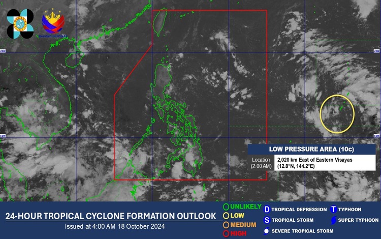
Low-Pressure Area Outside PAR
As of 2:00 AM today, Pagasa reports that a cloud cluster outside the Philippine Area of Responsibility (PAR) has developed into a Low Pressure Area (LPA). This LPA, designated as 10c, currently has a low chance of developing into a tropical depression within the next 24 hours. However, Pagasa continues to monitor its movement closely.