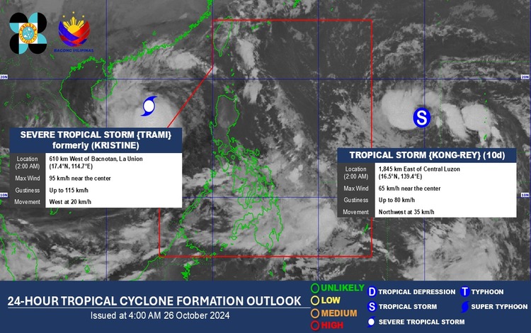
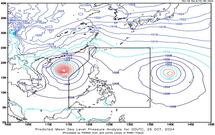
the Philippine Atmospheric, Geophysical, and Astronomical Services Administration (Pagasa) reported the latest updates on two tropical cyclones, both currently outside the Philippine Area of Responsibility (PAR): Severe Tropical Storm Trami, formerly known as Typhoon Kristine, and Tropical Storm Kong-rey, locally named Leon.

Severe Tropical Storm Trami (Kristine) Update
Severe Tropical Storm Trami, previously Typhoon Kristine, is currently located approximately 630 kilometers west of Bacnotan, La Union (coordinates: 17.3°N, 114.5°E). It has maximum sustained winds of 95 kilometers per hour (km/h) near its center, with gusts reaching up to 115 km/h. The storm continues to move westward at 20 km/h and is expected to maintain this trajectory.
While Trami remains outside PAR, its trough is affecting the western sections of Southern Luzon, bringing significant rain and weather disturbances to certain areas. Pagasa advises caution in these regions, particularly given the potential for moderate to heavy rainfall that may trigger flash floods and landslides.
Tropical Storm Kong-rey (Leon) Update
Tropical Storm Kong-rey, locally known as Leon, was recorded at a position 1,825 kilometers east of Central Luzon (coordinates: 16.5°N, 139.2°E) as of the same 3:00 AM report. Kong-rey has maximum sustained winds of 65 km/h near its center and gustiness of up to 80 km/h. The storm is moving northwestward at a faster pace of 35 km/h. As it progresses, Pagasa is monitoring Kong-rey’s possible path and any potential impacts on Philippine weather conditions should it approach the PAR boundary.
Forecasted Weather Conditions in Affected Areas
Due to the influence of Trami’s trough and the southwest monsoon, various parts of the Philippines will experience distinct weather conditions. The following areas are advised to take precautionary measures due to expected rainfall and the possible associated risks:
- Occidental Mindoro and Palawan: Cloudy skies with scattered rain showers and thunderstorms are forecasted in these areas, influenced by the trough of Severe Tropical Storm Trami. Residents should be alert for potential flash floods and landslides, especially in low-lying areas, as rainfall may be moderate to heavy at times.
- Visayas, Zamboanga Peninsula, and Northern Mindanao: The southwest wind flow is expected to bring cloudy skies with scattered rain showers and thunderstorms to these regions. Pagasa has warned of possible flash floods and landslides due to the anticipated intensity of the rains in affected areas.
- Metro Manila and the Rest of the Philippines: The rest of the country, including Metro Manila, can expect partly cloudy to cloudy skies with isolated rain showers or thunderstorms, primarily due to localized thunderstorms. While these are generally isolated, intense thunderstorms may still lead to severe rainfall, possibly causing flash floods or landslides in prone areas.

Forecasted Wind and Coastal Water Conditions
Pagasa has also issued advisories on wind and coastal water conditions for various regions, as follows:
- Luzon: Moderate to strong winds are expected, blowing from the southwest to the southeast, which will likely result in rough coastal waters with waves ranging between 2.8 to 4.0 meters in height. These conditions may pose challenges for small seacraft and fishing boats, and caution is advised for all marine activities.
- Visayas and Mindanao: These areas will experience slight to moderate winds coming from the southwest to the west, causing moderate to rough seas with wave heights between 1.5 to 2.5 meters. While conditions are less intense than in Luzon, boat operators and fishers should still exercise caution.
Advisory and Safety Recommendations
Pagasa urges residents, particularly in areas expected to experience significant rainfall, to remain vigilant and monitor updates on the weather. Authorities also recommend preparing for potential evacuations in flood-prone and landslide-susceptible zones, particularly in Occidental Mindoro, Palawan, Visayas, Zamboanga Peninsula, and Northern Mindanao.
Communities in affected areas are advised to stay informed through local government announcements, weather updates from Pagasa, and emergency instructions if conditions worsen.
